
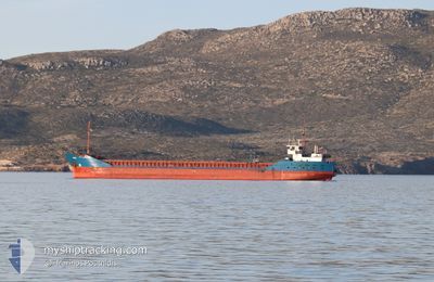
JULIETA
General Cargo
Current Trip
| Time Travelled | 1 day |
|---|---|
| Remaining Time | --- |
| Distance Travelled | 21.92 nm |
| Remaining Distance | --- |
| AVG Speed | 7.4 Knots |
| MAX Speed | 8.6 Knots |
| AVG Wind | 9.6 knots |
| MAX Wind | 10.5 knots |
| MIN Temp | 12.5°C / 54.5°F |
| MAX Temp | 14.5°C / 58.1°F |
| Draught | 4.4 m |
| Position Received | 1 d ago |
Current Position
| Longitude | 4.80954° |
|---|---|
| Latitude | 43.38043° |
| Status | Under way using engine |
| Speed | 3.4 Knots |
| Course | 269° |
| Area | Mediterranean Sea - Western Basin |
| Station | T-AIS |
| Position Received | 1 d ago |
Info
Information
The current position of JULIETA is in Mediterranean Sea - Western Basin with coordinates 43.38043° / 4.80954° as reported on 2025-03-07 06:20 by AIS to our vessel tracker app. The vessel's current speed is 3.4 Knots
The vessel JULIETA (IMO: 9115913, MMSI: 305992000) is a General Cargo that was built in 1995 ( 30 years old ). It's sailing under the flag of [AG] Antigua Barbuda.
In this page you can find informations about the vessels current position, last detected port calls, and current voyage information. If the vessels is not in coverage by AIS you will find the latest position.
The current position of JULIETA is detected by our AIS receivers and we are not responsible for the reliability of the data. The last position was recorded while the vessel was in Coverage by the Ais receivers of our vessel tracking app.
The current draught of JULIETA as reported by AIS is 4.4 meters
Weather
| Temperature | 15.4°C / 59.72°F |
|---|---|
| Wind Speed | 12 knots |
| Direction | 158° SSE |
| Pressure | 1016.8 hPa |
| Humidity | 55.1 % |
| Cloud Coverage | 100 % |
Featured Company
Last Port Calls
| Port | Arrival | Departure | Time In Port |
|---|---|---|---|
| 2025-03-07 05:25 | 2025-03-07 06:30 | 1 h | |
| 2025-02-26 00:41 | 2025-02-27 17:25 | 1 d | |
| 2025-02-18 17:06 | 2025-02-18 20:07 | 3 h | |
| 2025-02-14 17:29 | 2025-02-14 18:49 | 1 h | |
| 2025-01-29 00:44 | 2025-01-31 01:53 | 2 d | |
| 2025-01-10 10:51 | 2025-01-13 20:27 | 3 d | |
| 2025-01-06 14:06 | 2025-01-07 18:42 | 1 d | |
| 2025-01-05 19:45 | 2025-01-05 20:37 | 52 m | |
| 2025-01-05 10:20 | 2025-01-05 19:33 | 9 h |
Most Visited Ports (Last year)
| Port | Arrivals | |
|---|---|---|
| 17 | ||
| 11 | ||
| 3 | ||
| 2 | ||
| 2 | ||
| 2 |
Last Trips
| Origin | Departure | Destination | Arrival | Distance | |
|---|---|---|---|---|---|
| 2025-02-27 20:25 | 2025-03-07 06:25 | 1636.46 nm | |||
| 2025-02-18 21:07 | 2025-02-26 03:41 | 1640.26 nm | |||
| 2025-02-14 19:49 | 2025-02-18 18:06 | 32.07 nm | |||
| 2025-01-31 04:53 | 2025-02-14 18:29 | 1955.20 nm | |||
| 2025-01-13 21:27 | 2025-01-29 03:44 | 1926.12 nm | |||
| 2025-01-07 19:42 | 2025-01-10 11:51 | 441.35 nm | |||
| 2025-01-05 21:37 | 2025-01-06 15:06 | 70.80 nm | |||
| 2025-01-05 20:33 | 2025-01-05 20:45 | 0.35 nm | |||
| 2024-12-30 07:32 | 2025-01-05 11:20 | 44.24 nm |
Events
| Time | Event | Details | Position / Dest | Info |
|---|---|---|---|---|
| 2025-03-07 10:08 | STOP Moving | 17.69 nm, North of SALIN DE GIRAUD |
43.70055 / 4.62347
FRARL
|
Speed: 0.1 kn Course: 325° |
| 2025-03-07 06:30 | PORT DEPARTURE |
|
43.39080 / 4.78644
FRARL
|
Speed: 5.8 kn Course: 308° |
| 2025-03-07 06:22 | Status Changed | Default Under way using engine |
43.38133 / 4.80617
[FR] SAINT LOUIS DU RHONE
|
Speed: 3.4 kn Course: 269° |
| 2025-03-07 06:20 | START Moving |
43.38043 / 4.80954
[FR] SAINT LOUIS DU RHONE
|
Speed: 3.4 kn Course: 269° |
|
| 2025-03-07 06:20 | OUT of Coverage |
43.38043 / 4.80954
Mediterranean Sea - Western Basin
FRARL
|
Speed: 3.4 kn Course: 228.4° |
|
| 2025-03-07 06:19 | Status Changed | Under way using engine Default |
43.38166 / 4.80996
[FR] SAINT LOUIS DU RHONE
|
Speed: 2.7 kn Course: 153° |
| 2025-03-07 06:18 | Status Changed | Default Under way using engine |
43.38233 / 4.80944
[FR] SAINT LOUIS DU RHONE
|
Speed: Course: 146° |
| 2025-03-07 06:08 | Status Changed | Under way using engine Default |
43.38349 / 4.80845
[FR] SAINT LOUIS DU RHONE
|
Speed: 0.1 kn Course: 145° |
| 2025-03-07 05:54 | Status Changed | Default Under way using engine |
43.38351 / 4.80845
[FR] SAINT LOUIS DU RHONE
|
Speed: 0.1 kn Course: 146° |
| 2025-03-07 05:48 | STOP Moving |
43.38350 / 4.80844
[FR] SAINT LOUIS DU RHONE
|
Speed: 0.1 kn Course: 146° |