

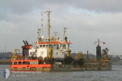
KENFORD
Trailing Suction Hopper Dredger

Current Trip
NG LOS
| Time Travelled | 4 h, 31 mins |
|---|---|
| Remaining Time | --- |
| Distance Travelled | 4.61 nm |
| Remaining Distance | --- |
| AVG Speed | 6.7 Knots |
| MAX Speed | 6.9 Knots |
| AVG Wind | 12.5 knots |
| MAX Wind | 13.9 knots |
| MIN Temp | 27.3°C / 81.14°F |
| MAX Temp | 27.6°C / 81.68°F |
| Draught | 3.5 m |
| Position Received | 10 h, 52 m ago |
Current Position
| Longitude | 3.39457° |
|---|---|
| Latitude | 6.43229° |
| Status | Restricted manoeuverability |
| Speed | 6.1 Knots |
| Course | 285° |
| Area | Gulf of Guinea |
| Station | T-AIS |
| Position Received | 10 h, 52 m ago |
Information
The current position of KENFORD is in Gulf of Guinea with coordinates 6.43229° / 3.39457° as reported on 2025-05-24 16:57 by AIS to our vessel tracker app. The vessel's current speed is 6.1 Knots
The vessel KENFORD (IMO: 8821826, MMSI: 312678000) is a Trailing Suction Hopper Dredger that was built in 1990 ( 35 years old ). It's sailing under the flag of [BZ] Belize.
In this page you can find informations about the vessels current position, last detected port calls, and current voyage information. If the vessels is not in coverage by AIS you will find the latest position.
The current position of KENFORD is detected by our AIS receivers and we are not responsible for the reliability of the data. The last position was recorded while the vessel was in Coverage by the Ais receivers of our vessel tracking app.
The current draught of KENFORD as reported by AIS is 3.5 meters
Weather
| Temperature | 27.4°C / 81.32°F |
|---|---|
| Wind Speed | 12 knots |
| Direction | 208° SSW |
| Pressure | 1012.6 hPa |
| Humidity | 80.3 % |
| Cloud Coverage | 99 % |


Featured Company
Last Port Calls
| Port | Arrival | Departure | Time In Port |
|---|---|---|---|
| 2025-05-24 22:46 | 2025-05-25 00:18 | 1 h | |
| 2025-05-24 17:46 | 2025-05-24 20:18 | 2 h | |
| 2025-05-24 15:01 | 2025-05-24 16:39 | 1 h | |
| 2025-05-24 12:50 | 2025-05-24 14:02 | 1 h | |
| 2025-05-24 09:45 | 2025-05-24 11:02 | 1 h | |
| 2025-05-24 05:38 | 2025-05-24 07:10 | 1 h | |
| 2025-05-24 02:22 | 2025-05-24 03:38 | 1 h | |
| 2025-05-23 23:34 | 2025-05-24 00:46 | 1 h | |
| 2025-05-23 19:57 | 2025-05-23 21:58 | 2 h | |
| 2025-05-23 16:34 | 2025-05-23 17:50 | 1 h |
Most Visited Ports (Last year)
| Port | Arrivals | |
|---|---|---|
| 729 | ||
| 239 | ||
| 49 | ||
| 1 | ||
| 1 |
Last Trips
| Origin | Departure | Destination | Arrival | Distance | |
|---|---|---|---|---|---|
| 2025-05-24 20:18 | 2025-05-24 22:46 | 12.91 nm | |||
| 2025-05-24 16:39 | 2025-05-24 17:46 | 7.05 nm | |||
| 2025-05-24 14:02 | 2025-05-24 15:01 | 6.08 nm | |||
| 2025-05-24 11:02 | 2025-05-24 12:50 | 9.44 nm | |||
| 2025-05-24 07:10 | 2025-05-24 09:45 | 12.40 nm | |||
| 2025-05-24 03:38 | 2025-05-24 05:38 | 10.76 nm | |||
| 2025-05-24 00:46 | 2025-05-24 02:22 | 8.87 nm | |||
| 2025-05-23 21:58 | 2025-05-23 23:34 | 9.01 nm | |||
| 2025-05-23 17:50 | 2025-05-23 19:57 | 10.82 nm | |||
| 2025-05-23 15:06 | 2025-05-23 16:34 | 8.45 nm |
Events
| Time | Event | Details | Position / Dest | Info |
|---|---|---|---|---|
| 2025-05-25 01:17 | STOP Moving | 5.65 nm, South East of LAGOS |
6.36667 / 3.43333
NG LOS
|
Speed: Course: -1° |
| 2025-05-24 23:18 | PORT DEPARTURE |
|
6.38723 / 3.40471
NG LOS
|
Speed: 7.4 kn Course: 163° |
| 2025-05-24 22:22 | START Moving |
6.43061 / 3.33347
[NG] LAGOS
|
Speed: 7.3 kn Course: 124° |
|
| 2025-05-24 21:46 | STOP Moving |
6.43644 / 3.32966
[NG] LAGOS
|
Speed: 0.3 kn Course: 253° |
|
| 2025-05-24 21:46 | PORT ARRIVAL |
|
6.43644 / 3.32966
[NG] LAGOS
|
Speed: 0.6 kn Course: 254° |
| 2025-05-24 19:18 | PORT DEPARTURE |
|
6.38928 / 3.40274
NG LOS
|
Speed: 9.7 kn Course: 178° |
| 2025-05-24 18:30 | START Moving |
6.43291 / 3.33113
[NG] LAGOS
|
Speed: 4.9 kn Course: 144° |
|
| 2025-05-24 18:15 | STOP Moving |
6.43643 / 3.32961
[NG] LAGOS
|
Speed: 0.1 kn Course: 254° |
|
| 2025-05-24 17:02 | Status Changed | Default Restricted manoeuverability |
6.43505 / 3.38605
[NG] LAGOS
|
Speed: 6.1 kn Course: 285° |
| 2025-05-24 16:57 | OUT of Coverage |
6.43229 / 3.39457
Gulf of Guinea
[NG] LAGOS
|
Speed: 6.1 kn Course: 281.4° |