

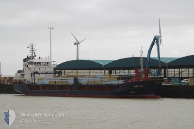
KERTU
General Cargo

Current Trip
| Trip Time | 22 days |
|---|---|
| Trip Distance | 2497.77 nm |
| AVG Speed | 9.5 Knots |
| MAX Speed | 12.4 Knots |
| Draught | 5.8 m |
| AVG Wind | 12 knots |
| MAX Wind | 26 knots |
| MIN Temp | 1.5°C / 34.7°F |
| MAX Temp | 17.3°C / 63.14°F |
| Position Received | 1 m ago |
Current Position
| Longitude | 0.35182° |
|---|---|
| Latitude | 51.45436° |
| Status | Moored |
| Speed | |
| Course | 63° |
| Area | North Sea |
| Station | T-AIS |
| Position Received | 1 m ago |
Information
The current position of KERTU is in North Sea with coordinates 51.45436° / 0.35182° as reported on 2025-05-28 05:41 by AIS to our vessel tracker app. The vessel's current speed is 0 Knots and is currently inside the port of TILBURY.
The vessel KERTU (IMO: 9344368, MMSI: 256956000) is a General Cargo that was built in 2005 ( 20 years old ). It's sailing under the flag of [MT] Malta.
In this page you can find informations about the vessels current position, last detected port calls, and current voyage information. If the vessels is not in coverage by AIS you will find the latest position.
The current position of KERTU is detected by our AIS receivers and we are not responsible for the reliability of the data. The last position was recorded while the vessel was in Coverage by the Ais receivers of our vessel tracking app.
The current draught of KERTU as reported by AIS is 5.8 meters
Weather
| Temperature | 13.6°C / 56.48°F |
|---|---|
| Wind Speed | 10 knots |
| Direction | 261° W |
| Pressure | 1011.9 hPa |
| Humidity | 86 % |
| Cloud Coverage | 82 % |


Featured Company
Last Port Calls
| Port | Arrival | Departure | Time In Port |
|---|---|---|---|
| 2025-05-25 19:51 | |||
| 2025-04-30 12:23 | 2025-05-03 17:52 | 3 d | |
| 2025-04-12 11:49 | 2025-04-17 12:45 | 5 d | |
| 2025-03-31 15:56 | 2025-04-02 17:38 | 2 d | |
| 2025-03-26 05:32 | 2025-03-29 13:45 | 3 d | |
| 2025-03-20 02:55 | 2025-03-21 01:53 | 22 h | |
| 2025-03-14 04:11 | 2025-03-18 17:15 | 4 d | |
| 2025-03-05 20:43 |
Last Trips
| Origin | Departure | Destination | Arrival | Distance | |
|---|---|---|---|---|---|
| 2025-05-03 17:52 | 2025-05-25 19:51 | 2497.77 nm | |||
| 2025-04-17 12:45 | 2025-04-30 12:23 | 2301.46 nm | |||
| 2025-04-02 17:38 | 2025-04-12 11:49 | 1392.54 nm | |||
| 2025-03-29 13:45 | 2025-03-31 15:56 | 576.14 nm | |||
| 2025-03-21 01:53 | 2025-03-26 05:32 | 1176.80 nm | |||
| 2025-03-18 17:15 | 2025-03-20 02:55 | 327.35 nm | |||
| 2025-03-05 20:43 | 2025-03-14 04:11 | 1887.39 nm |
Events
| Time | Event | Details | Position / Dest | Info |
|---|---|---|---|---|
| 2025-05-25 19:49 | Status Changed | Moored Under way using engine |
51.45441 / .35162
[GB] TILBURY
|
Speed: 0.3 kn Course: 57° |
| 2025-05-25 19:12 | STOP Moving |
51.45483 / .34200
[GB] TILBURY
|
Speed: 0.3 kn Course: 97° |
|
| 2025-05-25 18:51 | PORT ARRIVAL |
|
51.45360 / .33497
[GB] TILBURY
|
Speed: 3.8 kn Course: 323° |
| 2025-05-25 13:25 | START Moving | 5.06 nm, North of RAMSGATE |
51.41000 / 1.42183
GBTIL
|
Speed: 3.2 kn Course: 30° |
| 2025-05-25 13:23 | Status Changed | Under way using engine At anchor |
51.40937 / 1.42218
GBTIL
|
Speed: 0.3 kn Course: 290° |
| 2025-05-25 07:57 | STOP Moving | 4.96 nm, North of RAMSGATE |
51.40832 / 1.41796
GBTIL
|
Speed: 0.3 kn Course: 122° |
| 2025-05-25 07:43 | Status Changed | At anchor Under way using engine |
51.41023 / 1.42189
GBTIL
|
Speed: 1.7 kn Course: 194° |
| 2025-05-25 07:32 | Status Changed | Under way using engine At anchor |
51.41101 / 1.41305
GBTIL
|
Speed: 4.2 kn Course: 61° |
| 2025-05-25 07:27 | START Moving | 5.21 nm, North of RAMSGATE |
51.41226 / 1.41292
GBTIL
|
Speed: 3.9 kn Course: 173° |
| 2025-05-25 06:45 | STOP Moving | 5.28 nm, North of RAMSGATE |
51.41343 / 1.41516
GBTIL
|
Speed: 0.3 kn Course: 252° |