
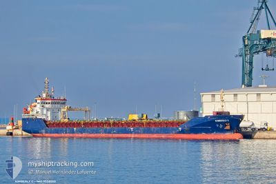
KIMBERLY C
General Cargo
Current Trip
| Time Travelled | 10 days |
|---|---|
| Remaining Time | --- |
| Distance Travelled | 1884.40 nm |
| Remaining Distance | --- |
| AVG Speed | 9.4 Knots |
| MAX Speed | 12.9 Knots |
| AVG Wind | 13.2 knots |
| MAX Wind | 36 knots |
| MIN Temp | 5.8°C / 42.44°F |
| MAX Temp | 16.6°C / 61.88°F |
| Draught | 6.2 m |
| Position Received | 3 m ago |
Current Position
| Longitude | 29.07501° |
|---|---|
| Latitude | 40.46493° |
| Status | At anchor |
| Speed | |
| Course | 251° |
| Area | Sea of Marmara |
| Station | T-AIS |
| Position Received | 3 m ago |
Info
Information
The current position of KIMBERLY C is in Sea of Marmara with coordinates 40.46493° / 29.07501° as reported on 2026-01-04 18:57 by AIS to our vessel tracker app. The vessel's current speed is 0 Knots
The vessel KIMBERLY C (IMO: 9558050, MMSI: 255806518) is a General Cargo that was built in 2011 ( 15 years old ). It's sailing under the flag of [PT] Portugal.
In this page you can find informations about the vessels current position, last detected port calls, and current voyage information. If the vessels is not in coverage by AIS you will find the latest position.
The current position of KIMBERLY C is detected by our AIS receivers and we are not responsible for the reliability of the data. The last position was recorded while the vessel was in Coverage by the Ais receivers of our vessel tracking app.
The current draught of KIMBERLY C as reported by AIS is 6.2 meters
Weather
| Temperature | 11.6°C / 52.88°F |
|---|---|
| Wind Speed | 8 knots |
| Direction | 204° SSW |
| Pressure | 1018.7 hPa |
| Humidity | 72.7 % |
| Cloud Coverage | 100 % |
Featured Company
Last Port Calls
| Port | Arrival | Departure | Time In Port |
|---|---|---|---|
| 2025-12-25 13:25 | 2025-12-25 19:18 | 5 h | |
| 2025-12-15 21:51 | 2025-12-16 18:27 | 20 h | |
| 2025-12-12 17:26 | 2025-12-14 00:22 | 1 d | |
| 2025-12-07 12:13 | 2025-12-10 19:16 | 3 d | |
| 2025-12-02 15:10 | 2025-12-06 16:59 | 4 d | |
| 2025-11-16 16:00 | 2025-12-02 00:43 | 15 d | |
| 2025-11-09 16:19 | 2025-11-16 15:45 | 6 d | |
| 2025-11-02 06:20 |
Last Trips
| Origin | Departure | Destination | Arrival | Distance | |
|---|---|---|---|---|---|
| 2025-12-16 18:27 | 2025-12-25 13:25 | 1420.37 nm | |||
| 2025-12-14 00:22 | 2025-12-15 21:51 | 123.58 nm | |||
| 2025-12-10 19:16 | 2025-12-12 17:26 | 446.74 nm | |||
| 2025-12-06 16:59 | 2025-12-07 12:13 | 160.60 nm | |||
| 2025-12-02 00:43 | 2025-12-02 15:10 | 138.82 nm | |||
| 2025-11-16 15:45 | 2025-11-16 16:00 | 0.66 nm | |||
| 2025-11-02 06:20 | 2025-11-09 16:19 | 1418.98 nm |
Events
| Time | Event | Details | Position / Dest | Info |
|---|---|---|---|---|
| 2026-01-04 13:27 | Status Changed | At anchor Default |
40.46555 / 29.07463
GEMLIK
|
Speed: Course: 220° |
| 2026-01-04 13:21 | Status Changed | Default At anchor |
40.46537 / 29.07450
GEMLIK
|
Speed: Course: 226° |
| 2026-01-04 10:27 | Status Changed | At anchor Default |
40.46539 / 29.07410
GEMLIK
|
Speed: 0.1 kn Course: 201° |
| 2026-01-04 10:21 | Status Changed | Default At anchor |
40.46543 / 29.07414
GEMLIK
|
Speed: Course: 201° |
| 2026-01-04 06:45 | Status Changed | At anchor Default |
40.46526 / 29.07319
GEMLIK
|
Speed: Course: 200° |
| 2026-01-04 06:39 | Status Changed | Default At anchor |
40.46529 / 29.07339
GEMLIK
|
Speed: Course: 195° |
| 2026-01-04 03:15 | Status Changed | At anchor Default |
40.46529 / 29.07392
GEMLIK
|
Speed: Course: 196° |
| 2026-01-04 03:06 | Status Changed | Default At anchor |
40.46531 / 29.07389
GEMLIK
|
Speed: Course: 200° |
| 2026-01-04 00:51 | Status Changed | At anchor Default |
40.46496 / 29.07435
GEMLIK
|
Speed: 0.1 kn Course: 249° |
| 2026-01-04 00:51 | IN Coverage |
40.46496 / 29.07435
Sea of Marmara
|
Speed: 0.1 kn Course: 297° |