
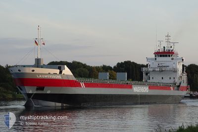
LAUWERSBORG
General Cargo
Current Trip
| Time Travelled | 16 h, 55 mins |
|---|---|
| Remaining Time | --- |
| Distance Travelled | 153.89 nm |
| Remaining Distance | --- |
| AVG Speed | 9.1 Knots |
| MAX Speed | 11.4 Knots |
| AVG Wind | 19.5 knots |
| MAX Wind | 32 knots |
| MIN Temp | 10.6°C / 51.08°F |
| MAX Temp | 14.8°C / 58.64°F |
| Draught | 4.4 m |
| Position Received | 8 h, 12 m ago |
Current Position
| Longitude | 13.47612° |
|---|---|
| Latitude | 44.06109° |
| Status | Under way using engine |
| Speed | 9.5 Knots |
| Course | 124.5° |
| Area | Adriatic Sea |
| Station | T-AIS |
| Position Received | 8 h, 12 m ago |
Info
Information
The current position of LAUWERSBORG is in Adriatic Sea with coordinates 44.06109° / 13.47612° as reported on 2025-12-23 20:15 by AIS to our vessel tracker app. The vessel's current speed is 9.5 Knots and is heading at the port of ASTAKOS. The estimated time of arrival as calculated by MyShipTracking vessel tracking app is 2025-12-26 09:00 LT
The vessel LAUWERSBORG (IMO: 9399387, MMSI: 244828000) is a General Cargo that was built in 2007 ( 18 years old ). It's sailing under the flag of [NL] Netherlands.
In this page you can find informations about the vessels current position, last detected port calls, and current voyage information. If the vessels is not in coverage by AIS you will find the latest position.
The current position of LAUWERSBORG is detected by our AIS receivers and we are not responsible for the reliability of the data. The last position was recorded while the vessel was in Coverage by the Ais receivers of our vessel tracking app.
The current draught of LAUWERSBORG as reported by AIS is 4.4 meters
Weather
| Temperature | 14.8°C / 58.64°F |
|---|---|
| Wind Speed | 17 knots |
| Direction | 115° ESE |
| Pressure | 1002.9 hPa |
| Humidity | 74.8 % |
| Cloud Coverage | 100 % |
Featured Company
Last Port Calls
| Port | Arrival | Departure | Time In Port |
|---|---|---|---|
| 2025-12-16 07:24 | 2025-12-23 12:33 | 7 d | |
| 2025-12-05 20:46 | 2025-12-09 12:57 | 3 d | |
| 2025-12-01 01:10 | 2025-12-04 23:28 | 3 d | |
| 2025-11-22 11:54 | 2025-11-22 21:18 | 9 h | |
| 2025-11-12 00:10 | 2025-11-16 13:22 | 4 d | |
| 2025-11-08 11:18 | |||
| 2025-11-01 03:27 | 2025-11-02 11:27 | 1 d | |
| 2025-10-28 14:55 | 2025-10-30 20:30 | 2 d | |
| 2025-10-26 16:23 | 2025-10-26 18:45 | 2 h | |
| 2025-10-18 13:40 | 2025-10-21 00:32 | 2 d |
Last Trips
| Origin | Departure | Destination | Arrival | Distance | |
|---|---|---|---|---|---|
| 2025-12-09 12:57 | 2025-12-16 07:24 | 1122.20 nm | |||
| 2025-12-04 23:28 | 2025-12-05 20:46 | 131.24 nm | |||
| 2025-11-22 21:18 | 2025-12-01 01:10 | 1793.05 nm | |||
| 2025-11-16 13:22 | 2025-11-22 11:54 | 1603.01 nm | |||
| 2025-11-08 11:18 | 2025-11-12 00:10 | 873.75 nm | |||
| 2025-10-30 20:30 | 2025-11-01 03:27 | 327.40 nm | |||
| 2025-10-26 18:45 | 2025-10-28 14:55 | 330.85 nm | |||
| 2025-10-21 00:32 | 2025-10-26 16:23 | 997.08 nm | |||
| 2025-10-18 12:12 | 2025-10-18 13:40 | 16.17 nm | |||
| 2025-10-10 09:31 | 2025-10-14 01:40 | 865.56 nm |
Events
| Time | Event | Details | Position / Dest | Info |
|---|---|---|---|---|
| 2025-12-23 20:22 | Status Changed | Default Under way using engine |
44.05107 / 13.49646
GRAST
|
Speed: 9.5 kn Course: 124.5° |
| 2025-12-23 20:15 | OUT of Coverage |
44.06109 / 13.47612
Adriatic Sea
GRAST
|
Speed: 9.5 kn Course: 124.5° |
|
| 2025-12-23 20:15 | Status Changed | Under way using engine Default |
44.06160 / 13.47510
GRAST
|
Speed: 9.7 kn Course: 126° |
| 2025-12-23 20:14 | Status Changed | Default Under way using engine |
44.06316 / 13.47207
GRAST
|
Speed: 10.1 kn Course: 125.2° |
| 2025-12-23 19:43 | Status Changed | Under way using engine Default |
44.11430 / 13.37231
GRAST
|
Speed: 10.7 kn Course: 126° |
| 2025-12-23 19:34 | IN Coverage |
44.10912 / 13.38218
Adriatic Sea
GRAST
|
Speed: 10.4 kn Course: 127.4° |
|
| 2025-12-23 15:46 | Status Changed | Default Under way using engine |
44.74916 / 12.94637
GRAST
|
Speed: 11.2 kn Course: 153.9° |
| 2025-12-23 15:39 | Status Changed | Under way using engine Default |
44.76829 / 12.93349
GRAST
|
Speed: 11.2 kn Course: 154° |
| 2025-12-23 15:39 | OUT of Coverage |
44.76829 / 12.93349
Adriatic Sea
GRAST
|
Speed: 11.2 kn Course: 153.9° |
|
| 2025-12-23 14:51 | Status Changed | Default Under way using engine |
44.89889 / 12.84457
GRAST
|
Speed: 11.2 kn Course: 154° |