
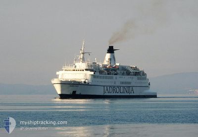
MARKO POLO
Ro-Ro/Passenger Ship
Current Trip
| Time Travelled | 4 h, 36 mins |
|---|---|
| Remaining Time | --- |
| Distance Travelled | 33.27 nm |
| Remaining Distance | --- |
| AVG Speed | 12.4 Knots |
| MAX Speed | 14.1 Knots |
| AVG Wind | 3.7 knots |
| MAX Wind | 4.4 knots |
| MIN Temp | 11.2°C / 52.16°F |
| MAX Temp | 11.7°C / 53.06°F |
| Draught | 5.5 m |
| Position Received | 4 h, 40 m ago |
Current Position
| Longitude | 13.48840° |
|---|---|
| Latitude | 43.63152° |
| Status | Under way using engine |
| Speed | 7.4 Knots |
| Course | 313° |
| Area | Adriatic Sea |
| Station | T-AIS |
| Position Received | 4 h, 40 m ago |
Info
Information
The current position of MARKO POLO is in Adriatic Sea with coordinates 43.63152° / 13.48840° as reported on 2025-02-07 19:00 by AIS to our vessel tracker app. The vessel's current speed is 7.4 Knots
The vessel MARKO POLO (IMO: 7230599, MMSI: 238144000) is a Ro-Ro/Passenger Ship that was built in 1973 ( 52 years old ). It's sailing under the flag of [HR] Croatia.
In this page you can find informations about the vessels current position, last detected port calls, and current voyage information. If the vessels is not in coverage by AIS you will find the latest position.
The current position of MARKO POLO is detected by our AIS receivers and we are not responsible for the reliability of the data. The last position was recorded while the vessel was in Coverage by the Ais receivers of our vessel tracking app.
The current draught of MARKO POLO as reported by AIS is 5.5 meters
Weather
| Temperature | 11.8°C / 53.24°F |
|---|---|
| Wind Speed | 3 knots |
| Direction | 237° WSW |
| Pressure | 1028.6 hPa |
| Humidity | 63.8 % |
| Cloud Coverage | 23 % |
Featured Company
Last Port Calls
| Port | Arrival | Departure | Time In Port |
|---|---|---|---|
| 2025-02-06 06:50 | 2025-02-07 20:05 | 1 d | |
| 2025-02-05 06:43 | 2025-02-05 20:03 | 13 h | |
| 2025-02-03 06:57 | 2025-02-04 20:09 | 1 d | |
| 2025-02-01 06:37 | 2025-02-02 20:07 | 1 d | |
| 2025-01-30 06:49 | 2025-01-31 20:09 | 1 d | |
| 2025-01-29 06:47 | 2025-01-29 19:59 | 13 h | |
| 2025-01-27 06:57 | 2025-01-28 20:13 | 1 d | |
| 2025-01-25 06:32 | 2025-01-26 20:04 | 1 d | |
| 2025-01-23 06:49 | 2025-01-24 20:01 | 1 d | |
| 2025-01-18 06:44 | 2025-01-22 20:00 | 4 d |
Most Visited Ports (Last year)
| Port | Arrivals | |
|---|---|---|
| 222 | ||
| 135 | ||
| 85 | ||
| 16 | ||
| 3 | ||
| 1 |
Last Trips
| Origin | Departure | Destination | Arrival | Distance | |
|---|---|---|---|---|---|
| 2025-02-05 20:03 | 2025-02-06 06:50 | 132.88 nm | |||
| 2025-02-04 20:09 | 2025-02-05 06:43 | 130.85 nm | |||
| 2025-02-02 20:07 | 2025-02-03 06:57 | 131.64 nm | |||
| 2025-01-31 20:09 | 2025-02-01 06:37 | 131.14 nm | |||
| 2025-01-29 19:59 | 2025-01-30 06:49 | 132.63 nm | |||
| 2025-01-28 20:13 | 2025-01-29 06:47 | 131.33 nm | |||
| 2025-01-26 20:04 | 2025-01-27 06:57 | 126.41 nm | |||
| 2025-01-24 20:01 | 2025-01-25 06:32 | 131.80 nm | |||
| 2025-01-22 20:00 | 2025-01-23 06:49 | 133.39 nm | |||
| 2025-01-17 20:06 | 2025-01-18 06:44 | 131.64 nm |
Events
| Time | Event | Details | Position / Dest | Info |
|---|---|---|---|---|
| 2025-02-07 19:05 | Status Changed | Default Under way using engine |
43.63795 / 13.49528
HRSPU
|
Speed: 7.4 kn Course: 313° |
| 2025-02-07 19:05 | PORT DEPARTURE |
|
43.63795 / 13.49528
HRSPU
|
Speed: 7.4 kn Course: 313° |
| 2025-02-07 19:00 | OUT of Coverage |
43.63152 / 13.48840
Adriatic Sea
|
Speed: 7.4 kn Course: 311.3° |
|
| 2025-02-07 18:58 | Status Changed | Under way using engine Default |
43.62952 / 13.49180
[IT] ANCONA
|
Speed: 7.3 kn Course: 359° |
| 2025-02-07 18:53 | START Moving |
43.62292 / 13.50017
[IT] ANCONA
|
Speed: 8.2 kn Course: 285° |
|
| 2025-02-07 18:53 | IN Coverage |
43.62952 / 13.49180
Adriatic Sea
[IT] ANCONA
|
Speed: 7 kn Course: 324° |
|
| 2025-02-06 06:05 | STOP Moving |
43.62193 / 13.50782
[IT] ANCONA
|
Speed: Course: 266° |
|
| 2025-02-06 05:57 | Status Changed | Default Under way using engine |
43.62120 / 13.50382
[IT] ANCONA
|
Speed: 10 kn Course: 155° |
| 2025-02-06 05:50 | OUT of Coverage |
43.62974 / 13.49192
Adriatic Sea
[IT] ANCONA
|
Speed: 10 kn Course: 148.3° |
|
| 2025-02-06 05:50 | PORT ARRIVAL |
|
43.63001 / 13.49168
[IT] ANCONA
|
Speed: 10.6 kn Course: 144.9° |