
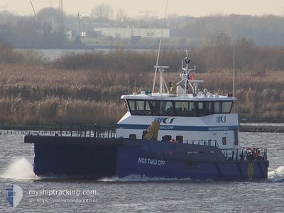
MCS TAKU CPP
High speed craft
Current Trip
| Trip Time | 4 h, 11 mins |
|---|---|
| Trip Distance | 61.14 nm |
| AVG Speed | 15.4 Knots |
| MAX Speed | 15.4 Knots |
| Draught | 2.2 m |
| AVG Wind | 11.7 knots |
| MAX Wind | 13 knots |
| MIN Temp | 9.4°C / 48.92°F |
| MAX Temp | 10.9°C / 51.62°F |
| Position Received | 2 m ago |
Current Position
| Longitude | 1.42001° |
|---|---|
| Latitude | 51.32939° |
| Status | Moored |
| Speed | |
| Course | 140° |
| Area | North Sea |
| Station | T-AIS |
| Position Received | 2 m ago |
Info
Information
The current position of MCS TAKU CPP is in North Sea with coordinates 51.32939° / 1.42001° as reported on 2025-12-23 22:21 by AIS to our vessel tracker app. The vessel's current speed is 0 Knots and is currently inside the port of RAMSGATE.
The vessel MCS TAKU CPP (IMO: 9749776, MMSI: 235107648) is a High speed craft It's sailing under the flag of [GB] United Kingdom.
In this page you can find informations about the vessels current position, last detected port calls, and current voyage information. If the vessels is not in coverage by AIS you will find the latest position.
The current position of MCS TAKU CPP is detected by our AIS receivers and we are not responsible for the reliability of the data. The last position was recorded while the vessel was in Coverage by the Ais receivers of our vessel tracking app.
The current draught of MCS TAKU CPP as reported by AIS is 2.2 meters
Weather
| Temperature | 6.9°C / 44.42°F |
|---|---|
| Wind Speed | 23 knots |
| Direction | 71° ENE |
| Pressure | 1023.8 hPa |
| Humidity | 75.7 % |
| Cloud Coverage | 100 % |
Featured Company
Last Port Calls
| Port | Arrival | Departure | Time In Port |
|---|---|---|---|
| 2025-12-22 22:23 | |||
| 2025-12-20 21:46 | 2025-12-22 18:12 | 1 d | |
| 2025-12-20 06:36 | 2025-12-20 17:09 | 10 h | |
| 2025-12-20 03:00 | 2025-12-20 03:23 | 23 m | |
| 2025-12-16 17:06 | 2025-12-19 17:19 | 3 d | |
| 2025-12-14 07:23 | 2025-12-16 12:54 | 2 d | |
| 2025-12-14 00:36 | 2025-12-14 06:29 | 5 h | |
| 2025-11-23 23:45 | 2025-12-13 17:42 | 19 d | |
| 2025-11-22 06:48 | 2025-11-23 21:20 | 1 d | |
| 2025-11-21 17:47 | 2025-11-22 05:52 | 12 h |
Last Trips
| Origin | Departure | Destination | Arrival | Distance | |
|---|---|---|---|---|---|
| 2025-12-22 18:12 | 2025-12-22 22:23 | 61.14 nm | |||
| 2025-12-20 17:09 | 2025-12-20 21:46 | 58.32 nm | |||
| 2025-12-20 03:23 | 2025-12-20 06:36 | 40.02 nm | |||
| 2025-12-19 17:19 | 2025-12-20 03:00 | 16.14 nm | |||
| 2025-12-16 12:54 | 2025-12-16 17:06 | 41.72 nm | |||
| 2025-12-14 06:29 | 2025-12-14 07:23 | 16.55 nm | |||
| 2025-12-13 17:42 | 2025-12-14 00:36 | 45.92 nm | |||
| 2025-11-23 21:20 | 2025-11-23 23:45 | 40.44 nm | |||
| 2025-11-22 05:52 | 2025-11-22 06:48 | 15.88 nm | |||
| 2025-11-21 16:59 | 2025-11-21 17:47 | 15.81 nm |
Events
| Time | Event | Details | Position / Dest | Info |
|---|---|---|---|---|
| 2025-12-22 22:29 | STOP Moving |
51.32940 / 1.42002
[GB] RAMSGATE
|
Speed: Course: 139° |
|
| 2025-12-22 22:23 | PORT ARRIVAL |
|
51.32522 / 1.42420
[GB] RAMSGATE
|
Speed: 18.9 kn Course: 274.3° |
| 2025-12-22 21:37 | Change Sea Area | United Kingdom part of the North Sea United Kingdom part of the English Channel |
51.13092 / 1.38081
North Sea
|
Speed: 17.3 kn Course: 33.5° |
| 2025-12-22 20:34 | Change Sea Area | United Kingdom part of the English Channel French part of the English Channel |
50.87991 / 1.26976
English Channel
|
Speed: 6 kn Course: 329.1° |
| 2025-12-22 19:46 | Change Sea Area | French part of the English Channel United Kingdom part of the English Channel |
50.90801 / 1.30471
English Channel
|
Speed: 22.6 kn Course: 202.3° |
| 2025-12-22 19:34 | Change Sea Area | United Kingdom part of the English Channel French part of the English Channel |
50.96425 / 1.38201
English Channel
|
Speed: 20.2 kn Course: 234.2° |
| 2025-12-22 19:26 | Change Sea Area | French part of the English Channel United Kingdom part of the English Channel |
50.96348 / 1.39789
English Channel
|
Speed: 17.6 kn Course: 140.3° |
| 2025-12-22 18:58 | Change Sea Area | United Kingdom part of the English Channel United Kingdom part of the North Sea |
51.08794 / 1.44873
English Channel
|
Speed: 22.4 kn Course: 170.2° |
| 2025-12-22 18:12 | PORT DEPARTURE |
|
51.32521 / 1.42711
SAR OPERATIONS
|
Speed: 15.3 kn Course: 86° |
| 2025-12-22 18:10 | START Moving |
51.32800 / 1.42177
[GB] RAMSGATE
|
Speed: 5.3 kn Course: 161° |