

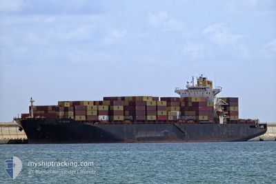
MSC HONG KONG V
Container Ship

Current Trip
| Time Travelled | 6 days |
|---|---|
| Remaining Time | 2 days |
| Distance Travelled | 2793.19 nm |
| Remaining Distance | 985.90 nm |
| AVG Speed | 17.2 Knots |
| MAX Speed | 19.5 Knots |
| AVG Wind | 15.3 knots |
| MAX Wind | 30 knots |
| MIN Temp | 12°C / 53.6°F |
| MAX Temp | 21.3°C / 70.34°F |
| Draught | 11.7 m |
| Position Received | 1 d ago |
Current Position
| Longitude | -41.28957° |
|---|---|
| Latitude | 42.06087° |
| Status | Under way using engine |
| Speed | 18 Knots |
| Course | 260.3° |
| Area | North Atlantic Ocean |
| Station | T-AIS |
| Position Received | 1 d ago |
Information
The current position of MSC HONG KONG V is in North Atlantic Ocean with coordinates 42.06087° / -41.28957° as reported on 2025-06-07 20:38 by AIS to our vessel tracker app. The vessel's current speed is 18 Knots and is heading at the port of NEW YORK. The estimated time of arrival as calculated by MyShipTracking vessel tracking app is 2025-06-11 06:37 LT
The vessel MSC HONG KONG V (IMO: 9231810, MMSI: 636021161) is a Container Ship that was built in 2002 ( 23 years old ). It's sailing under the flag of [LR] Liberia.
In this page you can find informations about the vessels current position, last detected port calls, and current voyage information. If the vessels is not in coverage by AIS you will find the latest position.
The current position of MSC HONG KONG V is detected by our AIS receivers and we are not responsible for the reliability of the data. The last position was recorded while the vessel was in Coverage by the Ais receivers of our vessel tracking app.
The current draught of MSC HONG KONG V as reported by AIS is 11.7 meters
Weather
| Temperature | 21.3°C / 70.34°F |
|---|---|
| Wind Speed | 29 knots |
| Direction | 210° SSW |
| Pressure | 1016.8 hPa |
| Humidity | 89 % |
| Cloud Coverage | 100 % |


Featured Company
Last Port Calls
| Port | Arrival | Departure | Time In Port |
|---|---|---|---|
| 2025-06-01 07:07 | 2025-06-02 12:09 | 1 d | |
| 2025-05-29 22:47 | 2025-05-31 00:32 | 1 d | |
| 2025-05-28 00:41 | 2025-05-29 09:27 | 1 d | |
| 2025-05-25 14:44 | 2025-05-26 01:20 | 10 h | |
| 2025-05-15 22:54 | 2025-05-16 16:29 | 17 h | |
| 2025-05-13 14:58 | 2025-05-14 07:23 | 16 h | |
| 2025-05-08 21:03 | 2025-05-10 01:59 | 1 d | |
| 2025-05-06 20:33 | 2025-05-07 19:33 | 23 h | |
| 2025-05-04 05:04 | 2025-05-05 01:17 | 20 h | |
| 2025-04-23 20:04 | 2025-04-24 18:29 | 22 h |
Most Visited Ports (Last year)
| Port | Arrivals | |
|---|---|---|
| 9 | ||
| 8 | ||
| 6 | ||
| 6 | ||
| 6 | ||
| 5 |
Last Trips
| Origin | Departure | Destination | Arrival | Distance | |
|---|---|---|---|---|---|
| 2025-05-31 00:32 | 2025-06-01 07:07 | 291.28 nm | |||
| 2025-05-29 09:27 | 2025-05-29 22:47 | 146.60 nm | |||
| 2025-05-26 01:20 | 2025-05-28 00:41 | 328.19 nm | |||
| 2025-05-16 16:29 | 2025-05-25 14:44 | 3451.49 nm | |||
| 2025-05-14 07:23 | 2025-05-15 22:54 | 598.74 nm | |||
| 2025-05-10 01:59 | 2025-05-13 14:58 | 586.23 nm | |||
| 2025-05-07 19:33 | 2025-05-08 21:03 | 129.03 nm | |||
| 2025-05-05 01:17 | 2025-05-06 20:33 | 641.97 nm | |||
| 2025-04-24 18:29 | 2025-05-04 05:04 | 3745.23 nm | |||
| 2025-04-22 20:34 | 2025-04-23 20:04 | 288.99 nm |
Events
| Time | Event | Details | Position / Dest | Info |
|---|---|---|---|---|
| 2025-06-07 20:42 | Status Changed | Default Under way using engine |
42.05764 / -41.31478
USNYC
|
Speed: 18 kn Course: 260.3° |
| 2025-06-07 20:38 | OUT of Coverage |
42.06087 / -41.28957
North Atlantic Ocean
USNYC
|
Speed: 18 kn Course: 260.3° |
|
| 2025-06-07 20:14 | Change Sea Area | High seas of the North Atlantic Ocean Spanish part of the North Atlantic Ocean |
42.08338 / -41.13107
North Atlantic Ocean
USNYC
|
Speed: 18.2 kn Course: 258° |
| 2025-06-07 20:14 | Status Changed | Under way using engine Default |
42.08338 / -41.13107
USNYC
|
Speed: 18.2 kn Course: 259° |
| 2025-06-07 20:04 | IN Coverage |
42.08338 / -41.13107
North Atlantic Ocean
USNYC
|
Speed: 18.2 kn Course: 258° |
|
| 2025-06-04 17:27 | Status Changed | Default Under way using engine |
46.11971 / -10.77628
USNYC
|
Speed: 18 kn Course: 231.4° |
| 2025-06-04 17:13 | Change Sea Area | Spanish part of the North Atlantic Ocean High seas of the North Atlantic Ocean |
46.16517 / -10.69962
North Atlantic Ocean
USNYC
|
Speed: 18 kn Course: 231.4° |
| 2025-06-04 17:13 | OUT of Coverage |
46.16517 / -10.69962
North Atlantic Ocean
USNYC
|
Speed: 18 kn Course: 231.4° |
|
| 2025-06-04 17:02 | Status Changed | Under way using engine Default |
46.20014 / -10.63997
USNYC
|
Speed: 17.6 kn Course: 223° |
| 2025-06-04 16:44 | Status Changed | Default Under way using engine |
46.25921 / -10.54827
USNYC
|
Speed: 17.5 kn Course: 224.9° |