

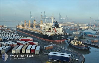
MYKONOS SEAS
Bulk Carrier

Current Trip
| Time Travelled | 27 days |
|---|---|
| Remaining Time | --- |
| Distance Travelled | 6802.82 nm |
| Remaining Distance | --- |
| AVG Speed | 10.2 Knots |
| MAX Speed | 13.8 Knots |
| AVG Wind | 11.5 knots |
| MAX Wind | 30 knots |
| MIN Temp | 12°C / 53.6°F |
| MAX Temp | 27.7°C / 81.86°F |
| Draught | 10 m |
| Position Received | 8 d ago |
Current Position
| Longitude | 32.33024° |
|---|---|
| Latitude | -29.86990° |
| Status | Under way using engine |
| Speed | 9.9 Knots |
| Course | 37.4° |
| Area | Indian Ocean |
| Station | T-AIS |
| Position Received | 8 d ago |
Information
The current position of MYKONOS SEAS is in Indian Ocean with coordinates -29.86990° / 32.33024° as reported on 2025-05-29 15:03 by AIS to our vessel tracker app. The vessel's current speed is 9.9 Knots and is heading at the port of NACALA PORTO. The estimated time of arrival as calculated by MyShipTracking vessel tracking app is 2025-06-02 14:00 LT
The vessel MYKONOS SEAS (IMO: 9491240, MMSI: 636015849) is a Bulk Carrier that was built in 2011 ( 14 years old ). It's sailing under the flag of [LR] Liberia.
In this page you can find informations about the vessels current position, last detected port calls, and current voyage information. If the vessels is not in coverage by AIS you will find the latest position.
The current position of MYKONOS SEAS is detected by our AIS receivers and we are not responsible for the reliability of the data. The last position was recorded while the vessel was in Coverage by the Ais receivers of our vessel tracking app.
The current draught of MYKONOS SEAS as reported by AIS is 10 meters
Weather
| Temperature | 27°C / 80.6°F |
|---|---|
| Wind Speed | 15 knots |
| Direction | 124° SE |
| Pressure | 1014.7 hPa |
| Humidity | 76.5 % |
| Cloud Coverage | 100 % |


Featured Company
Last Port Calls
| Port | Arrival | Departure | Time In Port |
|---|---|---|---|
| 2025-05-04 04:39 | 2025-05-09 19:47 | 5 d | |
| 2025-04-24 22:31 | 2025-04-26 20:39 | 1 d | |
| 2025-04-10 11:57 | 2025-04-22 16:26 | 12 d |
Most Visited Ports (Last year)
| Port | Arrivals | |
|---|---|---|
| 2 | ||
| 2 | ||
| 1 | ||
| 1 | ||
| 1 | ||
| 1 |
Last Trips
| Origin | Departure | Destination | Arrival | Distance | |
|---|---|---|---|---|---|
| 2025-04-26 20:39 | 2025-05-04 04:39 | 825.12 nm | |||
| 2025-04-22 16:26 | 2025-04-24 22:31 | 629.93 nm | |||
| 2025-03-27 10:40 | 2025-04-10 11:57 | 3801.33 nm |
Events
| Time | Event | Details | Position / Dest | Info |
|---|---|---|---|---|
| 2025-06-03 03:47 | STOP Moving | 9.5 nm, North of NACALA PORTO |
-14.38521 / 40.69362
MZ MNC
|
Speed: 0.2 kn Course: 291° |
| 2025-05-29 15:09 | Status Changed | Default Under way using engine |
-29.85735 / 32.34120
MZ MNC
|
Speed: 9.9 kn Course: 37.4° |
| 2025-05-29 15:03 | Status Changed | Under way using engine Default |
-29.86990 / 32.33024
MZ MNC
|
Speed: 10.1 kn Course: 38° |
| 2025-05-29 15:03 | OUT of Coverage |
-29.86990 / 32.33024
Indian Ocean
MZ MNC
|
Speed: 9.9 kn Course: 37.4° |
|
| 2025-05-29 14:51 | IN Coverage |
-29.86990 / 32.33024
Indian Ocean
MZ MNC
|
Speed: 9.9 kn Course: 37.4° |
|
| 2025-05-29 13:29 | Status Changed | Default Under way using engine |
-30.06877 / 32.14010
MZ MNC
|
Speed: 9.7 kn Course: 41.7° |
| 2025-05-29 13:27 | OUT of Coverage |
-30.07352 / 32.13522
Indian Ocean
MZ MNC
|
Speed: 9.7 kn Course: 41.7° |
|
| 2025-05-29 12:36 | Draught Changed | 10 9.5 |
-30.18219 / 32.03564
MZ MNC
|
Speed: 9.9 kn Course: 36.2° |
| 2025-05-29 12:36 | Destination Changed | MZ MNC BR RIG |
-30.18219 / 32.03564
MZ MNC
|
Speed: 9.9 kn Course: 36.2° |
| 2025-05-29 12:36 | ETA Changed | 2025/06/02 12:00 2025/04/24 23:00 |
-30.18219 / 32.03564
MZ MNC
|
Speed: 9.9 kn Course: 36.2° |