
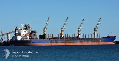
NIMBLE NICKY
Bulk Carrier
Current Trip
| Time Travelled | 1 day |
|---|---|
| Remaining Time | --- |
| Distance Travelled | 410.29 nm |
| Remaining Distance | --- |
| AVG Speed | 9.9 Knots |
| MAX Speed | 12.5 Knots |
| AVG Wind | 13.8 knots |
| MAX Wind | 26.1 knots |
| MIN Temp | 8.7°C / 47.66°F |
| MAX Temp | 14.2°C / 57.56°F |
| Draught | 9 m |
| Position Received | 1 d ago |
Current Position
| Longitude | -2.55136° |
|---|---|
| Latitude | 45.88954° |
| Status | Under way using engine |
| Speed | 12.5 Knots |
| Course | 248.1° |
| Area | Bay of Biscay |
| Station | T-AIS |
| Position Received | 1 d ago |
Info
Information
The current position of NIMBLE NICKY is in Bay of Biscay with coordinates 45.88954° / -2.55136° as reported on 2025-02-12 06:14 by AIS to our vessel tracker app. The vessel's current speed is 12.5 Knots and is heading at the port of REUNION. The estimated time of arrival as calculated by MyShipTracking vessel tracking app is 2025-03-13 01:00 LT
The vessel NIMBLE NICKY (IMO: 9424091, MMSI: 538008601) is a Bulk Carrier that was built in 2010 ( 15 years old ). It's sailing under the flag of [MH] Marshall Is.
In this page you can find informations about the vessels current position, last detected port calls, and current voyage information. If the vessels is not in coverage by AIS you will find the latest position.
The current position of NIMBLE NICKY is detected by our AIS receivers and we are not responsible for the reliability of the data. The last position was recorded while the vessel was in Coverage by the Ais receivers of our vessel tracking app.
The current draught of NIMBLE NICKY as reported by AIS is 9 meters
Weather
| Temperature | 14.1°C / 57.38°F |
|---|---|
| Wind Speed | 26 knots |
| Direction | 199° SSW |
| Pressure | 1015 hPa |
| Humidity | 89 % |
| Cloud Coverage | 100 % |
Featured Company
Last Port Calls
| Port | Arrival | Departure | Time In Port |
|---|---|---|---|
| 2025-02-04 15:25 | 2025-02-12 00:56 | 7 d | |
| 2025-01-24 19:16 | 2025-01-29 13:22 | 4 d | |
| 2025-01-17 16:10 | 2025-01-21 20:50 | 4 d | |
| 2024-12-05 00:27 | 2024-12-05 00:44 | 16 m | |
| 2024-12-01 08:43 | 2024-12-01 09:34 | 50 m |
Most Visited Ports (Last year)
| Port | Arrivals | |
|---|---|---|
| 4 | ||
| 2 | ||
| 1 | ||
| 1 | ||
| 1 | ||
| 1 |
Last Trips
| Origin | Departure | Destination | Arrival | Distance | |
|---|---|---|---|---|---|
| 2025-01-29 14:22 | 2025-02-04 16:25 | 1525.52 nm | |||
| 2025-01-21 21:50 | 2025-01-24 20:16 | 857.55 nm | |||
| 2024-12-05 07:44 | 2025-01-17 17:10 | 11527.32 nm | |||
| 2024-12-01 16:34 | 2024-12-05 07:27 | 0.71 nm | |||
| 2024-11-15 06:28 | 2024-12-01 15:43 | 2747.28 nm |
Events
| Time | Event | Details | Position / Dest | Info |
|---|---|---|---|---|
| 2025-02-12 06:14 | OUT of Coverage |
45.88954 / -2.55136
Bay of Biscay
REREU
|
Speed: 12.5 kn Course: 248.1° |
|
| 2025-02-12 05:11 | IN Coverage |
45.96825 / -2.26421
Bay of Biscay
REREU
|
Speed: 12.2 kn Course: 246.4° |
|
| 2025-02-12 04:03 | OUT of Coverage |
46.06433 / -1.96705
Bay of Biscay
REREU
|
Speed: 11.9 kn Course: 245.5° |
|
| 2025-02-12 00:56 | PORT DEPARTURE |
|
46.15297 / -1.23959
REREU
|
Speed: 5.3 kn Course: 212° |
| 2025-02-12 00:53 | START Moving |
46.15581 / -1.23462
[FR] LA PALLICE
|
Speed: 3.1 kn Course: 238° |
|
| 2025-02-12 00:40 | Status Changed | Under way using engine Moored |
46.15237 / -1.23011
[FR] LA PALLICE
|
Speed: 0.2 kn Course: 55° |
| 2025-02-12 00:37 | Status Changed | Moored Default |
46.15229 / -1.23005
[FR] LA PALLICE
|
Speed: Course: 56° |
| 2025-02-12 00:34 | Status Changed | Default Moored |
46.15230 / -1.23005
[FR] LA PALLICE
|
Speed: Course: 56° |
| 2025-02-12 00:25 | Status Changed | Moored Default |
46.15233 / -1.23002
[FR] LA PALLICE
|
Speed: Course: 56° |
| 2025-02-12 00:22 | Status Changed | Default Moored |
46.15231 / -1.23005
[FR] LA PALLICE
|
Speed: Course: 56° |