
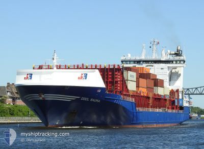
OOCL RAUMA
Container Ship
Current Trip
| Time Travelled | 22 h, 10 mins |
|---|---|
| Remaining Time | 8 h, 52 mins |
| Distance Travelled | 285.10 nm |
| Remaining Distance | 117.97 nm |
| AVG Speed | 12.9 Knots |
| MAX Speed | 14.3 Knots |
| AVG Wind | 9.9 knots |
| MAX Wind | 18 knots |
| MIN Temp | -0.8°C / 30.56°F |
| MAX Temp | 1.4°C / 34.52°F |
| Draught | 8 m |
| Position Received | Now |
Current Position
| Longitude | 23.69152° |
|---|---|
| Latitude | 59.60619° |
| Status | Under way using engine |
| Speed | 12.9 Knots |
| Course | 70.2° |
| Area | Gulf of Finland |
| Station | T-AIS |
| Position Received | Now |
Info
Information
The current position of OOCL RAUMA is in Gulf of Finland with coordinates 59.60619° / 23.69152° as reported on 2025-02-10 00:49 by AIS to our vessel tracker app. The vessel's current speed is 12.9 Knots and is heading at the port of KOTKA. The estimated time of arrival as calculated by MyShipTracking vessel tracking app is 2025-02-10 09:42 LT
The vessel OOCL RAUMA (IMO: 9462794, MMSI: 246650000) is a Container Ship that was built in 2009 ( 16 years old ). It's sailing under the flag of [NL] Netherlands.
In this page you can find informations about the vessels current position, last detected port calls, and current voyage information. If the vessels is not in coverage by AIS you will find the latest position.
The current position of OOCL RAUMA is detected by our AIS receivers and we are not responsible for the reliability of the data. The last position was recorded while the vessel was in Coverage by the Ais receivers of our vessel tracking app.
The current draught of OOCL RAUMA as reported by AIS is 8 meters
Weather
| Temperature | -0.7°C / 30.74°F |
|---|---|
| Wind Speed | 8 knots |
| Direction | 28° NNE |
| Pressure | 1042.3 hPa |
| Humidity | 75.9 % |
| Cloud Coverage | 97 % |
Featured Company
Last Port Calls
| Port | Arrival | Departure | Time In Port |
|---|---|---|---|
| 2025-02-08 16:46 | 2025-02-09 02:40 | 9 h | |
| 2025-02-07 07:15 | 2025-02-07 07:19 | 3 m | |
| 2025-02-05 05:17 | 2025-02-06 16:18 | 1 d | |
| 2025-02-04 03:55 | 2025-02-04 21:07 | 17 h | |
| 2025-01-31 09:29 | 2025-02-01 01:39 | 16 h | |
| 2025-01-29 17:13 | 2025-01-30 00:57 | 7 h | |
| 2025-01-24 18:54 | 2025-01-25 07:09 | 12 h | |
| 2025-01-21 13:09 | 2025-01-22 22:31 | 1 d | |
| 2025-01-20 20:29 | 2025-01-21 02:56 | 6 h | |
| 2025-01-19 07:44 | 2025-01-19 09:28 | 1 h |
Last Trips
| Origin | Departure | Destination | Arrival | Distance | |
|---|---|---|---|---|---|
| 2025-02-07 08:19 | 2025-02-08 18:46 | 410.29 nm | |||
| 2025-02-06 17:18 | 2025-02-07 08:15 | 88.58 nm | |||
| 2025-02-04 22:07 | 2025-02-05 06:17 | 124.03 nm | |||
| 2025-02-01 02:39 | 2025-02-04 04:55 | 506.06 nm | |||
| 2025-01-30 02:57 | 2025-01-31 10:29 | 443.47 nm | |||
| 2025-01-25 09:09 | 2025-01-29 19:13 | 496.01 nm | |||
| 2025-01-22 23:31 | 2025-01-24 20:54 | 500.27 nm | |||
| 2025-01-21 03:56 | 2025-01-21 14:09 | 125.44 nm | |||
| 2025-01-19 10:28 | 2025-01-20 21:29 | 156.07 nm | |||
| 2025-01-17 22:38 | 2025-01-19 08:44 | 366.53 nm |
Events
| Time | Event | Details | Position / Dest | Info |
|---|---|---|---|---|
| 2025-02-09 23:38 | Detected in Sea | Finnish part of the Gulf of Finland |
59.52946 / 23.22377
Gulf of Finland
FIKTK
|
Speed: 12.5 kn Course: 71.3° |
| 2025-02-09 23:32 | Change Sea Area | Estonian part of the Gulf of Finland Estonian part of the Baltic Sea |
59.52306 / 23.18533
Gulf of Finland
FIKTK
|
Speed: 12.6 kn Course: 71.8° |
| 2025-02-09 23:17 | Change Sea Area | Estonian part of the Baltic Sea Finnish part of the Baltic Sea |
59.50614 / 23.08563
Baltic Sea
FIKTK
|
Speed: 12.6 kn Course: 71.3° |
| 2025-02-09 22:42 | ETA Changed | 2025/02/10 08:00 2025/02/11 12:00 |
59.46746 / 22.85341
FIKTK
|
Speed: 13.2 kn Course: 71.6° |
| 2025-02-09 21:58 | Change Sea Area | Finnish part of the Baltic Sea Estonian part of the Baltic Sea |
59.40393 / 22.56636
Baltic Sea
FIKTK
|
Speed: 13.2 kn Course: 49.3° |
| 2025-02-09 21:38 | Status Changed | Under way using engine Default |
59.35495 / 22.45293
FIKTK
|
Speed: 13.4 kn Course: 52° |
| 2025-02-09 21:23 | IN Coverage |
59.35495 / 22.45293
Baltic Sea
FIKTK
|
Speed: 13.4 kn Course: 51.6° |
|
| 2025-02-09 20:25 | Status Changed | Default Under way using engine |
59.18540 / 22.04555
FIKTK
|
Speed: 13 kn Course: 50.9° |
| 2025-02-09 20:13 | Detected in Sea | Estonian part of the Baltic Sea |
59.15797 / 21.97833
Baltic Sea
FIKTK
|
Speed: 13 kn Course: 50.9° |
| 2025-02-09 20:13 | OUT of Coverage |
59.15797 / 21.97833
Baltic Sea
FIKTK
|
Speed: 13 kn Course: 50.9° |