
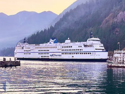
QUEEN OF OAK BAY
Ro-Ro/Passenger Ship
Current Trip
| Trip Time | 4 h, 52 mins |
|---|---|
| Trip Distance | 33.74 nm |
| AVG Speed | 6.8 Knots |
| MAX Speed | 7.8 Knots |
| Draught | 5.4 m |
| AVG Wind | 9.3 knots |
| MAX Wind | 13.7 knots |
| MIN Temp | 6.9°C / 44.42°F |
| MAX Temp | 7.7°C / 45.86°F |
| Position Received | 4 m ago |
Current Position
| Longitude | -123.12904° |
|---|---|
| Latitude | 49.00605° |
| Status | Moored |
| Speed | |
| Course | 7° |
| Area | The Coastal Waters of Southeast Alaska and British Columbia |
| Station | T-AIS |
| Position Received | 4 m ago |
Info
Information
The current position of QUEEN OF OAK BAY is in The Coastal Waters of Southeast Alaska and British Columbia with coordinates 49.00605° / -123.12904° as reported on 2025-03-21 21:58 by AIS to our vessel tracker app. The vessel's current speed is 0 Knots and is currently inside the port of TSAWWASSEN.
The vessel QUEEN OF OAK BAY (IMO: 7902283, MMSI: 316001257) is a Ro-Ro/Passenger Ship that was built in 1981 ( 44 years old ). It's sailing under the flag of [CA] Canada.
In this page you can find informations about the vessels current position, last detected port calls, and current voyage information. If the vessels is not in coverage by AIS you will find the latest position.
The current position of QUEEN OF OAK BAY is detected by our AIS receivers and we are not responsible for the reliability of the data. The last position was recorded while the vessel was in Coverage by the Ais receivers of our vessel tracking app.
The current draught of QUEEN OF OAK BAY as reported by AIS is 5.4 meters
Weather
| Temperature | 7.4°C / 45.32°F |
|---|---|
| Wind Speed | 14 knots |
| Direction | 204° SSW |
| Pressure | 1009.9 hPa |
| Humidity | 80.7 % |
| Cloud Coverage | 100 % |
Featured Company
Last Port Calls
| Port | Arrival | Departure | Time In Port |
|---|---|---|---|
| 2025-03-21 13:52 | |||
| 2025-02-07 07:21 | 2025-03-21 09:00 |
Most Visited Ports (Last year)
| Port | Arrivals | |
|---|---|---|
| 1 | ||
| 1 |
Last Trips
| Origin | Departure | Destination | Arrival | Distance | |
|---|---|---|---|---|---|
| 2025-03-21 09:00 | 2025-03-21 13:52 | 33.74 nm |
Events
| Time | Event | Details | Position / Dest | Info |
|---|---|---|---|---|
| 2025-03-21 21:55 | Status Changed | Moored Default |
49.00605 / -123.12904
[CA] TSAWWASSEN
|
Speed: Course: 7° |
| 2025-03-21 21:52 | Status Changed | Default Moored |
49.00605 / -123.12904
[CA] TSAWWASSEN
|
Speed: Course: 7° |
| 2025-03-21 21:41 | Status Changed | Moored Towing Astern |
49.00604 / -123.12906
[CA] TSAWWASSEN
|
Speed: 0.1 kn Course: 6° |
| 2025-03-21 21:12 | STOP Moving |
49.00092 / -123.13264
[CA] TSAWWASSEN
|
Speed: 0.2 kn Course: 341° |
|
| 2025-03-21 21:10 | START Moving |
49.00135 / -123.13344
[CA] TSAWWASSEN
|
Speed: 3.1 kn Course: 333° |
|
| 2025-03-21 21:07 | Change Sea Area | Canadian part of the The Coastal Waters of Southeast Alaska and British Columbia United States part of the The Coastal Waters of Southeast Alaska and British Columbia |
49.00111 / -123.13662
The Coastal Waters of Southeast Alaska and British Columbia
|
Speed: 2.8 kn Course: 67.7° |
| 2025-03-21 20:52 | STOP Moving |
48.99881 / -123.13967
[CA] TSAWWASSEN
|
Speed: 0.3 kn Course: 237° |
|
| 2025-03-21 20:52 | PORT ARRIVAL |
|
48.99880 / -123.13969
[CA] TSAWWASSEN
|
Speed: 0.6 kn Course: 234° |
| 2025-03-21 19:52 | Change Sea Area | United States part of the The Coastal Waters of Southeast Alaska and British Columbia Canadian part of the The Coastal Waters of Southeast Alaska and British Columbia |
48.99794 / -123.29944
The Coastal Waters of Southeast Alaska and British Columbia
|
Speed: 7.6 kn Course: 129.2° |
| 2025-03-21 16:00 | PORT DEPARTURE |
|
49.31710 / -123.14882
REFIT
|
Speed: 5.4 kn Course: 93° |