
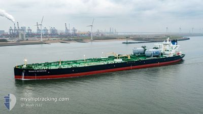
SEAWAYS ENTERPRISE
Tanker
Current Trip
| Time Travelled | 8 h, 1 mins |
|---|---|
| Remaining Time | --- |
| Distance Travelled | 64.41 nm |
| Remaining Distance | --- |
| AVG Speed | 11.1 Knots |
| MAX Speed | 13.4 Knots |
| AVG Wind | 10.8 knots |
| MAX Wind | 14 knots |
| MIN Temp | 18.2°C / 64.76°F |
| MAX Temp | 20.7°C / 69.26°F |
| Draught | 12.8 m |
| Position Received | 6 h, 6 m ago |
Current Position
| Longitude | -96.84882° |
|---|---|
| Latitude | 27.74476° |
| Status | Under way using engine |
| Speed | 11.6 Knots |
| Course | 58° |
| Area | Gulf of Mexico |
| Station | T-AIS |
| Position Received | 6 h, 6 m ago |
Info
Information
The current position of SEAWAYS ENTERPRISE is in Gulf of Mexico with coordinates 27.74476° / -96.84882° as reported on 2025-01-31 23:08 by AIS to our vessel tracker app. The vessel's current speed is 11.6 Knots and is heading at the port of CORPUS CHRISTI. The estimated time of arrival as calculated by MyShipTracking vessel tracking app is 2025-01-31 20:30 LT
The vessel SEAWAYS ENTERPRISE (IMO: 9933585, MMSI: 538010089) is a Tanker It's sailing under the flag of [MH] Marshall Is.
In this page you can find informations about the vessels current position, last detected port calls, and current voyage information. If the vessels is not in coverage by AIS you will find the latest position.
The current position of SEAWAYS ENTERPRISE is detected by our AIS receivers and we are not responsible for the reliability of the data. The last position was recorded while the vessel was in Coverage by the Ais receivers of our vessel tracking app.
The current draught of SEAWAYS ENTERPRISE as reported by AIS is 12.8 meters
Weather
| Temperature | 21°C / 69.8°F |
|---|---|
| Wind Speed | 8 knots |
| Direction | 26° NNE |
| Pressure | 1022.1 hPa |
| Humidity | 40.4 % |
| Cloud Coverage | 100 % |
Featured Company
Most Visited Ports (Last year)
| Port | Arrivals | |
|---|---|---|
| 2 | ||
| 1 | ||
| 1 | ||
| 1 | ||
| 1 |
Last Trips
| Origin | Departure | Destination | Arrival | Distance | |
|---|---|---|---|---|---|
| 2025-01-09 00:48 | 2025-01-29 17:55 | 5300.93 nm | |||
| 2024-11-01 22:22 | 2025-01-06 09:10 | 5817.75 nm |
Events
| Time | Event | Details | Position / Dest | Info |
|---|---|---|---|---|
| 2025-01-31 23:15 | Status Changed | Default Under way using engine |
27.75576 / -96.82509
US CRP
|
Speed: 11.6 kn Course: 58° |
| 2025-01-31 23:08 | OUT of Coverage |
27.74476 / -96.84882
Gulf of Mexico
US CRP
|
Speed: 11.6 kn Course: 58° |
|
| 2025-01-31 23:01 | Status Changed | Under way using engine Default |
27.74460 / -96.87360
US CRP
|
Speed: 13 kn Course: 118° |
| 2025-01-31 22:59 | Status Changed | Default Under way using engine |
27.74865 / -96.88212
US CRP
|
Speed: 12.9 kn Course: 126.2° |
| 2025-01-31 22:27 | Status Changed | Under way using engine Default |
27.80479 / -96.98521
US CRP
|
Speed: 9.7 kn Course: 121° |
| 2025-01-31 22:23 | Status Changed | Default Under way using engine |
27.80989 / -96.99481
US CRP
|
Speed: 11.2 kn Course: 122.8° |
| 2025-01-31 21:13 | PORT DEPARTURE |
|
27.82072 / -97.18451
US CRP
|
Speed: 6.5 kn Course: 79° |
| 2025-01-31 21:07 | START Moving |
27.81921 / -97.19307
[US] INGLESIDE
|
Speed: 3.1 kn Course: 77° |
|
| 2025-01-31 20:42 | Status Changed | Under way using engine Moored |
27.82229 / -97.19391
[US] INGLESIDE
|
Speed: Course: 16° |
| 2025-01-31 20:31 | ETA Changed | 2025/01/31 20:30 2025/01/31 20:00 |
27.82229 / -97.19393
[US] INGLESIDE
|
Speed: Course: 17° |