
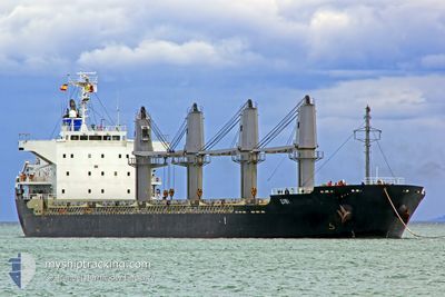
SIBI
Bulk Carrier
Current Trip
JABALALI
| Time Travelled | 11 days |
|---|---|
| Remaining Time | --- |
| Distance Travelled | 2730.51 nm |
| Remaining Distance | --- |
| AVG Speed | 10 Knots |
| MAX Speed | 12.6 Knots |
| AVG Wind | 9.1 knots |
| MAX Wind | 22.2 knots |
| MIN Temp | 23.5°C / 74.3°F |
| MAX Temp | 28.3°C / 82.94°F |
| Draught | 9.7 m |
| Position Received | 7 d ago |
Current Position
| Longitude | 102.09571° |
|---|---|
| Latitude | 2.09886° |
| Status | Under way using engine |
| Speed | 11.7 Knots |
| Course | 310.2° |
| Area | Malacca Strait |
| Station | T-AIS |
| Position Received | 7 d ago |
Info
Information
The current position of SIBI is in Malacca Strait with coordinates 2.09886° / 102.09571° as reported on 2025-12-28 12:24 by AIS to our vessel tracker app. The vessel's current speed is 11.7 Knots
The vessel SIBI (IMO: 9519224, MMSI: 463043101) is a Bulk Carrier that was built in 2009 ( 17 years old ). It's sailing under the flag of [PK] Pakistan.
In this page you can find informations about the vessels current position, last detected port calls, and current voyage information. If the vessels is not in coverage by AIS you will find the latest position.
The current position of SIBI is detected by our AIS receivers and we are not responsible for the reliability of the data. The last position was recorded while the vessel was in Coverage by the Ais receivers of our vessel tracking app.
The current draught of SIBI as reported by AIS is 9.7 meters
Weather
| Temperature | 27.6°C / 81.68°F |
|---|---|
| Wind Speed | 12 knots |
| Direction | 59° ENE |
| Pressure | 1010.8 hPa |
| Humidity | 69.1 % |
| Cloud Coverage | 100 % |
Featured Company
Events
| Time | Event | Details | Position / Dest | Info |
|---|---|---|---|---|
| 2025-12-28 12:28 | Status Changed | Default Under way using engine |
2.10884 / 102.08405
JABALALI
|
Speed: 11.7 kn Course: 310.2° |
| 2025-12-28 12:24 | OUT of Coverage |
2.09886 / 102.09571
Malacca Strait
|
Speed: 11.7 kn Course: 310.2° |
|
| 2025-12-28 11:57 | Draught Changed | 9.7 9.8 |
2.03989 / 102.16267
JABALALI
|
Speed: 11.7 kn Course: 313.2° |
| 2025-12-28 11:46 | Status Changed | Under way using engine Default |
2.01536 / 102.18941
JABALALI
|
Speed: 11.9 kn Course: 313° |
| 2025-12-28 11:44 | Status Changed | Default Under way using engine |
2.01270 / 102.19225
JABALALI
|
Speed: 11.9 kn Course: 312.4° |
| 2025-12-28 11:05 | Change Sea Area | Malaysian part of the Malacca Strait Indonesian part of the Singapore Strait |
1.93291 / 102.29245
Malacca Strait
|
Speed: 11.8 kn Course: 290.4° |
| 2025-12-28 11:05 | Status Changed | Under way using engine Default |
1.93272 / 102.29297
JABALALI
|
Speed: 11.7 kn Course: 291° |
| 2025-12-28 11:05 | IN Coverage |
1.93291 / 102.29245
Malacca Strait
|
Speed: 11.8 kn Course: 290.4° |
|
| 2025-12-28 03:04 | Status Changed | Default Under way using engine |
1.19825 / 103.59995
JABALALI
|
Speed: 11.7 kn Course: 279.3° |
| 2025-12-28 02:57 | OUT of Coverage |
1.19386 / 103.62395
Singapore Strait
|
Speed: 11.7 kn Course: 279.3° |