

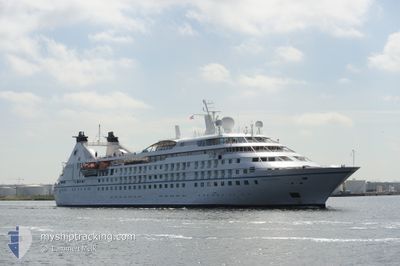
STAR LEGEND
Passengers Ship

Current Trip
| Time Travelled | 12 mins |
|---|---|
| Remaining Time | 7 h, 19 mins |
| Distance Travelled | 1.24 nm |
| Remaining Distance | 78.82 nm |
| AVG Speed | --- |
| MAX Speed | --- |
| AVG Wind | 19.5 knots |
| MAX Wind | 22.2 knots |
| MIN Temp | 12.2°C / 53.96°F |
| MAX Temp | 13.2°C / 55.76°F |
| Draught | 5.5 m |
| Position Received | 1 m ago |
Current Position
| Longitude | -6.09268° |
|---|---|
| Latitude | 53.32148° |
| Status | Under way using engine |
| Speed | 7.6 Knots |
| Course | 58.2° |
| Area | Irish Sea and St. George's Channel |
| Station | T-AIS |
| Position Received | 1 m ago |
Information
The current position of STAR LEGEND is in Irish Sea and St. George's Channel with coordinates 53.32148° / -6.09268° as reported on 2025-06-02 18:22 by AIS to our vessel tracker app. The vessel's current speed is 7.6 Knots and is heading at the port of DOUGLAS. The estimated time of arrival as calculated by MyShipTracking vessel tracking app is 2025-06-03 02:43 LT
The vessel STAR LEGEND (IMO: 9008598, MMSI: 311085000) is a Passengers Ship that was built in 1992 ( 33 years old ). It's sailing under the flag of [BS] Bahamas.
In this page you can find informations about the vessels current position, last detected port calls, and current voyage information. If the vessels is not in coverage by AIS you will find the latest position.
The current position of STAR LEGEND is detected by our AIS receivers and we are not responsible for the reliability of the data. The last position was recorded while the vessel was in Coverage by the Ais receivers of our vessel tracking app.
The current draught of STAR LEGEND as reported by AIS is 5.5 meters
Weather
| Temperature | 13.2°C / 55.76°F |
|---|---|
| Wind Speed | 22 knots |
| Direction | 190° S |
| Pressure | 1007.1 hPa |
| Humidity | 71.8 % |
| Cloud Coverage | 100 % |


Featured Company
Last Port Calls
| Port | Arrival | Departure | Time In Port |
|---|---|---|---|
| 2025-06-02 05:52 | 2025-06-02 19:12 | 13 h | |
| 2025-05-27 07:24 | 2025-05-28 20:52 | 1 d | |
| 2025-05-25 09:04 | 2025-05-25 18:08 | 9 h | |
| 2025-05-24 09:07 | 2025-05-24 16:10 | 7 h | |
| 2025-05-23 06:19 | 2025-05-23 16:58 | 10 h | |
| 2025-05-21 06:07 | 2025-05-21 21:23 | 15 h | |
| 2025-05-19 07:12 | 2025-05-20 14:58 | 1 d | |
| 2025-05-18 07:10 | 2025-05-18 21:54 | 14 h | |
| 2025-05-16 07:48 | 2025-05-17 22:45 | 1 d | |
| 2025-05-15 06:07 | 2025-05-15 16:52 | 10 h |
Last Trips
| Origin | Departure | Destination | Arrival | Distance | |
|---|---|---|---|---|---|
| 2025-05-28 20:52 | 2025-06-02 05:52 | 877.35 nm | |||
| 2025-05-25 18:08 | 2025-05-27 07:24 | 403.87 nm | |||
| 2025-05-24 16:10 | 2025-05-25 09:04 | 210.57 nm | |||
| 2025-05-23 16:58 | 2025-05-24 09:07 | 191.74 nm | |||
| 2025-05-21 21:23 | 2025-05-23 06:19 | 336.88 nm | |||
| 2025-05-20 14:58 | 2025-05-21 06:07 | 195.34 nm | |||
| 2025-05-18 21:54 | 2025-05-19 07:12 | 94.42 nm | |||
| 2025-05-17 22:45 | 2025-05-18 07:10 | 63.52 nm | |||
| 2025-05-15 16:52 | 2025-05-16 07:48 | 201.34 nm | |||
| 2025-05-13 17:22 | 2025-05-15 06:07 | 287.07 nm |
Events
| Time | Event | Details | Position / Dest | Info |
|---|---|---|---|---|
| 2025-06-02 18:12 | PORT DEPARTURE |
|
53.30432 / -6.12752
IMDGS
|
Speed: 8.7 kn Course: 27° |
| 2025-06-02 18:09 | START Moving |
53.29795 / -6.12883
[IE] DUN LAOGHAIRE
|
Speed: 5.4 kn Course: 355° |
|
| 2025-06-02 17:57 | Status Changed | Under way using engine Moored |
53.29552 / -6.12940
[IE] DUN LAOGHAIRE
|
Speed: Course: 30° |
| 2025-06-02 16:23 | Destination Changed | IMDGS IEDUB |
53.29552 / -6.12942
[IE] DUN LAOGHAIRE
|
Speed: Course: 30° |
| 2025-06-02 16:23 | ETA Changed | 2025/06/03 06:00 2025/06/02 04:00 |
53.29552 / -6.12942
[IE] DUN LAOGHAIRE
|
Speed: Course: 30° |
| 2025-06-02 05:16 | Status Changed | Moored At anchor |
53.29550 / -6.12938
[IE] DUN LAOGHAIRE
|
Speed: 0.1 kn Course: 31° |
| 2025-06-02 05:16 | Status Changed | At anchor Under way using engine |
53.29550 / -6.12937
[IE] DUN LAOGHAIRE
|
Speed: Course: 31° |
| 2025-06-02 05:09 | STOP Moving |
53.29543 / -6.12907
[IE] DUN LAOGHAIRE
|
Speed: 0.3 kn Course: 28° |
|
| 2025-06-02 04:52 | PORT ARRIVAL |
|
53.30293 / -6.12912
[IE] DUN LAOGHAIRE
|
Speed: 7 kn Course: 214.8° |
| 2025-06-02 01:17 | Status Changed | Under way using engine Default |
52.71520 / -5.89690
IEDUB
|
Speed: 10.9 kn Course: 4° |