
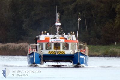
SWAROG
Cargo
Current Trip
| Time Travelled | 1 h, 59 mins |
|---|---|
| Remaining Time | --- |
| Distance Travelled | 5.41 nm |
| Remaining Distance | --- |
| AVG Speed | 5.5 Knots |
| MAX Speed | 7.4 Knots |
| AVG Wind | 9.1 knots |
| MAX Wind | 10.6 knots |
| MIN Temp | -1.1°C / 30.02°F |
| MAX Temp | 0.6°C / 33.08°F |
| Draught | 1.6 m |
| Position Received | 4 m ago |
Current Position
| Longitude | 9.08195° |
|---|---|
| Latitude | 53.87277° |
| Status | Restricted manoeuverability |
| Speed | 6.7 Knots |
| Course | 246.5° |
| Area | North Sea |
| Station | T-AIS |
| Position Received | 4 m ago |
Info
Information
The current position of SWAROG is in North Sea with coordinates 53.87277° / 9.08195° as reported on 2025-02-16 10:50 by AIS to our vessel tracker app. The vessel's current speed is 6.7 Knots
The vessel SWAROG (MMSI: 261000664) is a Cargo It's sailing under the flag of [PL] Poland.
In this page you can find informations about the vessels current position, last detected port calls, and current voyage information. If the vessels is not in coverage by AIS you will find the latest position.
The current position of SWAROG is detected by our AIS receivers and we are not responsible for the reliability of the data. The last position was recorded while the vessel was in Coverage by the Ais receivers of our vessel tracking app.
The current draught of SWAROG as reported by AIS is 1.6 meters
Weather
| Temperature | 0.2°C / 32.36°F |
|---|---|
| Wind Speed | 10 knots |
| Direction | 78° ENE |
| Pressure | 1026.4 hPa |
| Humidity | 65.1 % |
| Cloud Coverage | 75 % |
Featured Company
Last Port Calls
| Port | Arrival | Departure | Time In Port |
|---|---|---|---|
| 2025-02-15 16:53 | 2025-02-16 08:55 | 16 h | |
| 2025-02-14 16:10 | 2025-02-15 09:04 | 16 h | |
| 2025-02-13 11:47 | 2025-02-14 07:47 | 20 h | |
| 2025-02-12 16:27 | 2025-02-13 07:14 | 14 h | |
| 2025-02-10 13:45 | 2025-02-12 06:37 | 1 d | |
| 2024-12-20 12:48 | 2025-01-07 11:50 | 17 d | |
| 2024-12-10 10:37 | 2024-12-10 11:10 | 33 m |
Most Visited Ports (Last year)
| Port | Arrivals | |
|---|---|---|
| 47 | ||
| 23 | ||
| 7 | ||
| 6 | ||
| 3 | ||
| 2 |
Last Trips
| Origin | Departure | Destination | Arrival | Distance | |
|---|---|---|---|---|---|
| 2025-02-15 10:04 | 2025-02-15 17:53 | 24.63 nm | |||
| 2025-02-14 08:47 | 2025-02-14 17:10 | 30.25 nm | |||
| 2025-02-13 08:14 | 2025-02-13 12:47 | 18.06 nm | |||
| 2025-02-12 07:37 | 2025-02-12 17:27 | 35.90 nm | |||
| 2025-01-07 12:50 | 2025-02-10 14:45 | 413.85 nm | |||
| 2024-12-10 12:10 | 2024-12-20 13:48 | 143.35 nm | |||
| 2024-10-14 07:34 | 2024-12-10 11:37 | 442.75 nm |
Events
| Time | Event | Details | Position / Dest | Info |
|---|---|---|---|---|
| 2025-02-16 10:28 | Status Changed | Restricted manoeuverability Under way using engine |
53.87772 / 9.14549
BRUNSBUTTEL SURVEY
|
Speed: 5.9 kn Course: 280° |
| 2025-02-16 09:41 | START Moving | 1.58 nm, South of BRUNSBUETTEL |
53.87821 / 9.14522
BRUNSBUTTEL SURVEY
|
Speed: 3.8 kn Course: 351° |
| 2025-02-16 09:39 | STOP Moving | 1.58 nm, South of BRUNSBUETTEL |
53.87766 / 9.14861
BRUNSBUTTEL SURVEY
|
Speed: 0.2 kn Course: 84° |
| 2025-02-16 09:33 | ETA Changed | 2025/02/16 08:00 2025/02/15 08:00 |
53.88002 / 9.14555
BRUNSBUTTEL SURVEY
|
Speed: 5.7 kn Course: 168.8° |
| 2025-02-16 09:25 | START Moving | 0.98 nm, South West of BRUNSBUETTEL |
53.88951 / 9.14433
BRUNSBUTTEL SURVEY
|
Speed: 7.6 kn Course: 226.5° |
| 2025-02-16 09:07 | STOP Moving | 0.8 nm, South West of BRUNSBUETTEL |
53.89184 / 9.14782
BRUNSBUTTEL SURVEY
|
Speed: Course: 215° |
| 2025-02-16 08:55 | PORT DEPARTURE |
|
53.89603 / 9.15148
BRUNSBUTTEL SURVEY
|
Speed: 4.2 kn Course: 196° |
| 2025-02-16 08:53 | START Moving |
53.89867 / 9.15334
[DE] BRUNSBUETTEL
|
Speed: 6 kn Course: 201° |
|
| 2025-02-16 08:52 | Status Changed | Under way using engine Moored |
53.89943 / 9.15394
[DE] BRUNSBUETTEL
|
Speed: Course: 47° |
| 2025-02-16 07:35 | IN Coverage |
53.90075 / 9.15499
North Sea
[DE] BRUNSBUETTEL
|
Speed: Course: 47° |