
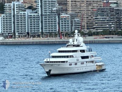
TITANIA
Yacht
Current Trip
| Trip Time | 2 days |
|---|---|
| Trip Distance | 742.62 nm |
| AVG Speed | 9.9 Knots |
| MAX Speed | 14.4 Knots |
| Draught | 3.7 m |
| AVG Wind | 5.7 knots |
| MAX Wind | 19 knots |
| MIN Temp | 9.6°C / 49.28°F |
| MAX Temp | 15.9°C / 60.62°F |
| Position Received | 17 m ago |
Current Position
| Longitude | -5.36297° |
|---|---|
| Latitude | 36.14540° |
| Status | Moored |
| Speed | |
| Course | 179° |
| Area | Strait of Gibraltar |
| Station | T-AIS |
| Position Received | 17 m ago |
Info
Information
The current position of TITANIA is in Strait of Gibraltar with coordinates 36.14540° / -5.36297° as reported on 2025-12-21 09:52 by AIS to our vessel tracker app. The vessel's current speed is 0 Knots and is currently inside the port of GIBRALTAR.
The vessel TITANIA (IMO: 1008695, MMSI: 235081036) is a Yacht that was built in 2006 ( 19 years old ). It's sailing under the flag of [GB] United Kingdom.
In this page you can find informations about the vessels current position, last detected port calls, and current voyage information. If the vessels is not in coverage by AIS you will find the latest position.
The current position of TITANIA is detected by our AIS receivers and we are not responsible for the reliability of the data. The last position was recorded while the vessel was in Coverage by the Ais receivers of our vessel tracking app.
The current draught of TITANIA as reported by AIS is 3.7 meters
Weather
| Temperature | 15.1°C / 59.18°F |
|---|---|
| Wind Speed | 18 knots |
| Direction | 260° W |
| Pressure | 1010.8 hPa |
| Humidity | 75 % |
| Cloud Coverage | 100 % |
Featured Company
Most Visited Ports (Last year)
| Port | Arrivals | |
|---|---|---|
| 5 | ||
| 5 | ||
| 2 | ||
| 2 | ||
| 2 | ||
| 2 |
Events
| Time | Event | Details | Position / Dest | Info |
|---|---|---|---|---|
| 2025-12-21 10:09 | Status Changed | Under way using engine Moored |
36.14540 / -5.36297
[GI] GIBRALTAR
|
Speed: Course: 179° |
| 2025-12-20 02:55 | Status Changed | Moored Under way using engine |
36.14540 / -5.36297
[GI] GIBRALTAR
|
Speed: Course: 181° |
| 2025-12-20 02:30 | STOP Moving |
36.14553 / -5.36383
[GI] GIBRALTAR
|
Speed: 0.1 kn Course: 132° |
|
| 2025-12-20 02:22 | PORT ARRIVAL |
|
36.14260 / -5.36892
[GI] GIBRALTAR
|
Speed: 5.1 kn Course: 59.6° |
| 2025-12-20 02:02 | Change Sea Area | Gibraltarian part of the Strait of Gibraltar Gibraltarian part of the Alboran Sea |
36.10138 / -5.36742
Strait of Gibraltar
GIB
|
Speed: 12.6 kn Course: 313.1° |
| 2025-12-20 00:54 | Detected in Sea | Gibraltarian part of the Alboran Sea |
36.12737 / -5.09055
Alboran Sea
GIB
|
Speed: 12.9 kn Course: 249.8° |
| 2025-12-20 00:53 | IN Coverage |
36.12737 / -5.09055
Alboran Sea
GIB
|
Speed: 12.9 kn Course: 249.8° |
|
| 2025-12-19 08:04 | OUT of Coverage |
37.33020 / -.90350
Mediterranean Sea - Western Basin
GIB
|
Speed: 14.2 kn Course: 229.4° |
|
| 2025-12-19 04:02 | Change Sea Area | Spanish part of the Mediterranean Sea - Western Basin Spanish part of the Balearic Sea |
38.02532 / -.17850
Mediterranean Sea - Western Basin
GIB
|
Speed: 13 kn Course: 212.7° |
| 2025-12-19 03:51 | IN Coverage |
38.05598 / -.15227
Balearic Sea
GIB
|
Speed: 13 kn Course: 214° |