
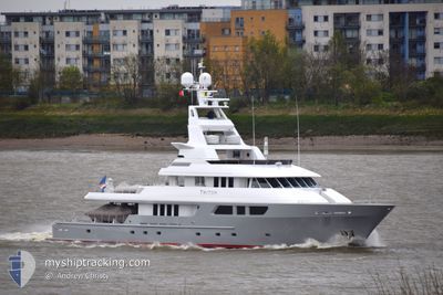
TRITON
Pleasure Craft
Current Trip
BVI
| Time Travelled | 5 h, 12 mins |
|---|---|
| Remaining Time | --- |
| Distance Travelled | 7.08 nm |
| Remaining Distance | --- |
| AVG Speed | 9.2 Knots |
| MAX Speed | 11.8 Knots |
| AVG Wind | 20.6 knots |
| MAX Wind | 21 knots |
| MIN Temp | 25.9°C / 78.62°F |
| MAX Temp | 26°C / 78.8°F |
| Draught | 3.5 m |
| Position Received | 1 m ago |
Current Position
| Longitude | -64.62125° |
|---|---|
| Latitude | 18.31904° |
| Status | At anchor |
| Speed | 0.1 Knots |
| Course | 114° |
| Area | Caribbean Sea |
| Station | T-AIS |
| Position Received | 1 m ago |
Info
Information
The current position of TRITON is in Caribbean Sea with coordinates 18.31904° / -64.62125° as reported on 2025-02-12 17:49 by AIS to our vessel tracker app. The vessel's current speed is 0.1 Knots
The vessel TRITON (IMO: 9093799, MMSI: 538070070) is a Pleasure Craft It's sailing under the flag of [MH] Marshall Is.
In this page you can find informations about the vessels current position, last detected port calls, and current voyage information. If the vessels is not in coverage by AIS you will find the latest position.
The current position of TRITON is detected by our AIS receivers and we are not responsible for the reliability of the data. The last position was recorded while the vessel was in Coverage by the Ais receivers of our vessel tracking app.
The current draught of TRITON as reported by AIS is 3.5 meters
Weather
| Temperature | 25.9°C / 78.62°F |
|---|---|
| Wind Speed | 21 knots |
| Direction | 85° E |
| Pressure | 1018.3 hPa |
| Humidity | 76.1 % |
| Cloud Coverage | 3 % |
Featured Company
Last Port Calls
| Port | Arrival | Departure | Time In Port |
|---|---|---|---|
| 2025-02-10 18:09 | 2025-02-12 08:38 | 1 d | |
| 2025-02-04 15:06 | 2025-02-08 11:16 | 3 d | |
| 2025-02-04 08:55 | |||
| 2025-01-10 21:31 | 2025-01-26 13:16 | 15 d | |
| 2025-01-06 13:45 | 2025-01-10 05:20 | 3 d | |
| 2024-12-27 08:17 | 2025-01-01 10:08 | 5 d | |
| 2024-12-26 22:51 | 2024-12-27 06:00 | 7 h | |
| 2024-12-26 05:20 | 2024-12-26 05:40 | 20 m |
Most Visited Ports (Last year)
| Port | Arrivals | |
|---|---|---|
| 3 | ||
| 3 | ||
| 2 | ||
| 2 | ||
| 2 | ||
| 1 |
Last Trips
| Origin | Departure | Destination | Arrival | Distance | |
|---|---|---|---|---|---|
| 2025-02-08 11:16 | 2025-02-10 18:09 | 28.87 nm | |||
| 2025-02-04 08:55 | 2025-02-04 15:06 | 40.26 nm | |||
| 2025-01-10 05:20 | 2025-01-10 21:31 | 162.76 nm | |||
| 2025-01-01 10:08 | 2025-01-06 13:45 | 209.99 nm | |||
| 2024-12-27 06:00 | 2024-12-27 08:17 | 11.93 nm | |||
| 2024-12-26 05:40 | 2024-12-26 22:51 | 177.85 nm | |||
| 2024-11-25 23:05 | 2024-12-26 05:20 | 1.14 nm |
Events
| Time | Event | Details | Position / Dest | Info |
|---|---|---|---|---|
| 2025-02-12 13:29 | Status Changed | At anchor Moored |
18.31879 / -64.62109
BVI
|
Speed: 0.2 kn Course: 52° |
| 2025-02-12 13:28 | Status Changed | Moored Under way using engine |
18.31866 / -64.62114
BVI
|
Speed: 0.2 kn Course: 55° |
| 2025-02-12 13:21 | STOP Moving | 0.33 nm, West of NORMAN ISLAND |
18.31873 / -64.62100
BVI
|
Speed: Course: 69° |
| 2025-02-12 13:08 | Change Sea Area | British Virgin Islands part of the Caribbean Sea Puerto Rican part of the Caribbean Sea |
18.32819 / -64.63440
Caribbean Sea
|
Speed: 9.2 kn Course: 130.9° |
| 2025-02-12 12:47 | Change Sea Area | Puerto Rican part of the Caribbean Sea British Virgin Islands part of the Caribbean Sea |
18.36734 / -64.68743
Caribbean Sea
|
Speed: 11.9 kn Course: 116.7° |
| 2025-02-12 12:38 | PORT DEPARTURE |
|
18.38286 / -64.70880
BVI
|
Speed: 5.7 kn Course: 208° |
| 2025-02-12 12:38 | START Moving |
18.38380 / -64.70839
[VG] SOPERS HOLE
|
Speed: 5.7 kn Course: 208° |
|
| 2025-02-12 12:20 | Status Changed | Under way using engine Moored |
18.38449 / -64.70804
[VG] SOPERS HOLE
|
Speed: Course: 36° |
| 2025-02-10 22:18 | Status Changed | Moored Under way using engine |
18.38431 / -64.70786
[VG] SOPERS HOLE
|
Speed: Course: 70° |
| 2025-02-10 22:09 | PORT ARRIVAL |
|
18.38460 / -64.70765
[VG] SOPERS HOLE
|
Speed: 1 kn Course: 101° |