
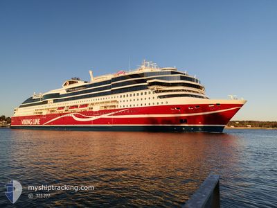
VIKING GLORY
Passenger
Current Trip
FITKU<>FIMAR/FILAN<>
| Time Travelled | 4 h, 52 mins |
|---|---|
| Remaining Time | --- |
| Distance Travelled | 73.68 nm |
| Remaining Distance | --- |
| AVG Speed | 14.9 Knots |
| MAX Speed | 20.9 Knots |
| AVG Wind | 8.7 knots |
| MAX Wind | 12 knots |
| MIN Temp | 1.3°C / 34.34°F |
| MAX Temp | 3.9°C / 39.02°F |
| Draught | 6.6 m |
| Position Received | 1 m ago |
Current Position
| Longitude | 18.25206° |
|---|---|
| Latitude | 59.35827° |
| Status | Under way using engine |
| Speed | 15.7 Knots |
| Course | 225.2° |
| Area | Baltic Sea |
| Station | T-AIS |
| Position Received | 1 m ago |
Info
Information
The current position of VIKING GLORY is in Baltic Sea with coordinates 59.35827° / 18.25206° as reported on 2025-03-22 17:19 by AIS to our vessel tracker app. The vessel's current speed is 15.7 Knots
The vessel VIKING GLORY (IMO: 9827877, MMSI: 230041000) is a Passenger It's sailing under the flag of [FI] Finland.
In this page you can find informations about the vessels current position, last detected port calls, and current voyage information. If the vessels is not in coverage by AIS you will find the latest position.
The current position of VIKING GLORY is detected by our AIS receivers and we are not responsible for the reliability of the data. The last position was recorded while the vessel was in Coverage by the Ais receivers of our vessel tracking app.
The current draught of VIKING GLORY as reported by AIS is 6.6 meters
Weather
| Temperature | 1.6°C / 34.88°F |
|---|---|
| Wind Speed | 8 knots |
| Direction | 118° ESE |
| Pressure | 1030.8 hPa |
| Humidity | 87.6 % |
| Cloud Coverage | 6 % |
Featured Company
Last Port Calls
| Port | Arrival | Departure | Time In Port |
|---|---|---|---|
| 2025-03-22 13:58 | 2025-03-22 14:28 | 30 m | |
| 2025-03-22 07:23 | 2025-03-22 08:45 | 1 h | |
| 2025-03-22 03:10 | 2025-03-22 03:22 | 12 m | |
| 2025-03-21 18:32 | 2025-03-21 20:08 | 1 h | |
| 2025-03-21 13:59 | 2025-03-21 14:29 | 29 m | |
| 2025-03-21 07:20 | 2025-03-21 08:43 | 1 h | |
| 2025-03-21 03:10 | 2025-03-21 03:22 | 12 m | |
| 2025-03-20 18:33 | 2025-03-20 20:08 | 1 h | |
| 2025-03-20 13:57 | 2025-03-20 14:27 | 29 m | |
| 2025-03-20 07:21 | 2025-03-20 08:45 | 1 h |
Most Visited Ports (Last year)
| Port | Arrivals | |
|---|---|---|
| 354 | ||
| 351 | ||
| 349 | ||
| 342 | ||
| 1 |
Last Trips
| Origin | Departure | Destination | Arrival | Distance | |
|---|---|---|---|---|---|
| 2025-03-22 08:45 | 2025-03-22 13:58 | 90.93 nm | |||
| 2025-03-22 03:22 | 2025-03-22 07:23 | 66.94 nm | |||
| 2025-03-21 20:08 | 2025-03-22 03:10 | 90.35 nm | |||
| 2025-03-21 14:29 | 2025-03-21 18:32 | 78.50 nm | |||
| 2025-03-21 08:43 | 2025-03-21 13:59 | 89.61 nm | |||
| 2025-03-21 03:22 | 2025-03-21 07:20 | 66.79 nm | |||
| 2025-03-20 20:08 | 2025-03-21 03:10 | 90.30 nm | |||
| 2025-03-20 14:27 | 2025-03-20 18:33 | 78.42 nm | |||
| 2025-03-20 08:45 | 2025-03-20 13:57 | 91.28 nm | |||
| 2025-03-20 03:20 | 2025-03-20 07:21 | 66.68 nm |
Events
| Time | Event | Details | Position / Dest | Info |
|---|---|---|---|---|
| 2025-03-22 13:38 | Change Sea Area | Swedish part of the Baltic Sea Swedish part of the Gulf of Bothnia |
59.83144 / 19.38612
Baltic Sea
FITKU<>FIMAR/FILAN<>
|
Speed: 20.4 kn Course: 215.6° |
| 2025-03-22 13:26 | Change Sea Area | Swedish part of the Gulf of Bothnia Finnish part of the Gulf of Bothnia |
59.87699 / 19.48670
Gulf of Bothnia
FITKU<>FIMAR/FILAN<>
|
Speed: 20.5 kn Course: 229.3° |
| 2025-03-22 12:28 | PORT DEPARTURE |
|
60.08581 / 19.92695
FITKU<>FIMAR/FILAN<>
|
Speed: 9.8 kn Course: 179° |
| 2025-03-22 12:26 | START Moving |
60.09034 / 19.92688
[FI] MARIEHAMN
|
Speed: 6 kn Course: 179° |
|
| 2025-03-22 12:06 | STOP Moving |
60.09222 / 19.92716
[FI] MARIEHAMN
|
Speed: 0.3 kn Course: 174° |
|
| 2025-03-22 11:58 | PORT ARRIVAL |
|
60.08763 / 19.92660
[FI] MARIEHAMN
|
Speed: 9.2 kn Course: 356.7° |
| 2025-03-22 06:45 | PORT DEPARTURE |
|
60.42922 / 22.19620
FITKU<>FIMAR/FILAN<>
|
Speed: 8.5 kn Course: 230° |
| 2025-03-22 06:40 | START Moving |
60.43385 / 22.21485
[FI] TURKU
|
Speed: 5.2 kn Course: 278° |
|
| 2025-03-22 05:38 | ETA Changed | 2025/03/22 17:55 2025/03/22 05:35 |
60.43374 / 22.21891
[FI] TURKU
|
Speed: Course: 288° |
| 2025-03-22 05:32 | STOP Moving |
60.43374 / 22.21889
[FI] TURKU
|
Speed: 0.2 kn Course: 287° |