
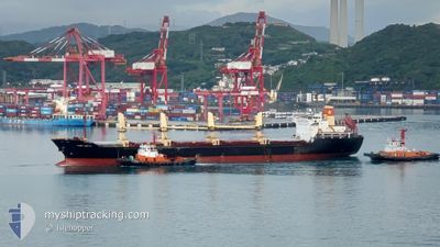
VIMC UNITY
Bulk Carrier
Current Trip
PKL<=>MALAI
| Time Travelled | 14 h, 44 mins |
|---|---|
| Remaining Time | --- |
| Distance Travelled | 168.51 nm |
| Remaining Distance | --- |
| AVG Speed | 11.7 Knots |
| MAX Speed | 14.1 Knots |
| AVG Wind | 5.9 knots |
| MAX Wind | 15.9 knots |
| MIN Temp | 24.9°C / 76.82°F |
| MAX Temp | 29°C / 84.2°F |
| Draught | 5.5 m |
| Position Received | 9 h, 45 m ago |
Current Position
| Longitude | 103.40791° |
|---|---|
| Latitude | 1.25130° |
| Status | Under way sailing |
| Speed | 14 Knots |
| Course | 297.9° |
| Area | Malacca Strait |
| Station | T-AIS |
| Position Received | 9 h, 45 m ago |
Info
Information
The current position of VIMC UNITY is in Malacca Strait with coordinates 1.25130° / 103.40791° as reported on 2025-03-03 13:15 by AIS to our vessel tracker app. The vessel's current speed is 14 Knots
The vessel VIMC UNITY (IMO: 9472062, MMSI: 574005000) is a Bulk Carrier that was built in 2007 ( 18 years old ). It's sailing under the flag of [VN] Vietnam.
In this page you can find informations about the vessels current position, last detected port calls, and current voyage information. If the vessels is not in coverage by AIS you will find the latest position.
The current position of VIMC UNITY is detected by our AIS receivers and we are not responsible for the reliability of the data. The last position was recorded while the vessel was in Coverage by the Ais receivers of our vessel tracking app.
The current draught of VIMC UNITY as reported by AIS is 5.5 meters
Weather
| Temperature | 26.5°C / 79.7°F |
|---|---|
| Wind Speed | 6 knots |
| Direction | 60° ENE |
| Pressure | 1007.2 hPa |
| Humidity | 77.6 % |
| Cloud Coverage | 43 % |
Featured Company
Last Trips
| Origin | Departure | Destination | Arrival | Distance | |
|---|---|---|---|---|---|
| 2025-02-26 17:36 | 2025-02-27 07:41 | 37.40 nm | |||
| 2025-02-22 06:29 | 2025-02-25 15:44 | 1130.79 nm | |||
| 2025-02-04 21:41 | 2025-02-20 09:12 | 2983.67 nm | |||
| 2025-01-25 05:08 | 2025-02-01 15:05 | 250.32 nm | |||
| 2024-12-22 10:07 | 2025-01-24 07:45 | 5476.79 nm |
Events
| Time | Event | Details | Position / Dest | Info |
|---|---|---|---|---|
| 2025-03-03 13:21 | Status Changed | Default Under way sailing |
1.26835 / 103.38892
PKL<=>MALAI
|
Speed: 14 kn Course: 297.9° |
| 2025-03-03 13:15 | OUT of Coverage |
1.25130 / 103.40791
Malacca Strait
PKL<=>MALAI
|
Speed: 14 kn Course: 297.9° |
|
| 2025-03-03 13:00 | Change Sea Area | Malaysian part of the Malacca Strait Malaysian part of the Singapore Strait |
1.23601 / 103.46198
Malacca Strait
PKL<=>MALAI
|
Speed: 14.1 kn Course: 283.7° |
| 2025-03-03 12:25 | Change Sea Area | Malaysian part of the Singapore Strait Indonesian part of the Singapore Strait |
1.20177 / 103.59432
Singapore Strait
PKL<=>MALAI
|
Speed: 13.8 kn Course: 285° |
| 2025-03-03 11:53 | Change Sea Area | Indonesian part of the Singapore Strait Singaporean part of the Singapore Strait |
1.15712 / 103.70206
Singapore Strait
PKL<=>MALAI
|
Speed: 12.5 kn Course: 301.8° |
| 2025-03-03 10:12 | ETA Changed | 2025/03/04 03:30 2025/03/04 08:00 |
1.25548 / 103.99349
PKL<=>MALAI
|
Speed: 11.4 kn Course: 249.7° |
| 2025-03-03 10:05 | Change Sea Area | Singaporean part of the Singapore Strait Indonesian part of the Singapore Strait |
1.26224 / 104.01489
Singapore Strait
PKL<=>MALAI
|
Speed: 11.1 kn Course: 265.2° |
| 2025-03-03 09:01 | Draught Changed | 5.5 7.3 |
1.18796 / 104.16545
PKL<=>MALAI
|
Speed: 10.2 kn Course: 334.5° |
| 2025-03-03 09:01 | Destination Changed | PKL<=>MALAI BATAM<=INDO |
1.18796 / 104.16545
PKL<=>MALAI
|
Speed: 10.2 kn Course: 334.5° |
| 2025-03-03 09:01 | ETA Changed | 2025/03/04 08:00 2025/02/26 13:30 |
1.18796 / 104.16545
PKL<=>MALAI
|
Speed: 10.2 kn Course: 334.5° |