
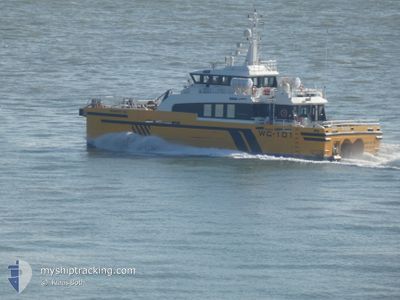
WINDCAT 101
Crew Boat
Current Trip
| Trip Time | 7 h, 58 mins |
|---|---|
| Trip Distance | 50.54 nm |
| AVG Speed | 16.8 Knots |
| MAX Speed | 16.8 Knots |
| Draught | 1.9 m |
| AVG Wind | 8.7 knots |
| MAX Wind | 11.7 knots |
| MIN Temp | 7.5°C / 45.5°F |
| MAX Temp | 9°C / 48.2°F |
| Position Received | 6 m ago |
Current Position
| Longitude | -0.07056° |
|---|---|
| Latitude | 53.58150° |
| Status | Under way using engine |
| Speed | |
| Course | 114° |
| Area | North Sea |
| Station | T-AIS |
| Position Received | 6 m ago |
Info
Information
The current position of WINDCAT 101 is in North Sea with coordinates 53.58150° / -0.07056° as reported on 2025-12-21 18:56 by AIS to our vessel tracker app. The vessel's current speed is 0 Knots and is currently inside the port of GRIMSBY.
The vessel WINDCAT 101 (IMO: 9574913, MMSI: 235086213) is a Crew Boat that was built in 2010 ( 15 years old ). It's sailing under the flag of [GB] United Kingdom.
In this page you can find informations about the vessels current position, last detected port calls, and current voyage information. If the vessels is not in coverage by AIS you will find the latest position.
The current position of WINDCAT 101 is detected by our AIS receivers and we are not responsible for the reliability of the data. The last position was recorded while the vessel was in Coverage by the Ais receivers of our vessel tracking app.
The current draught of WINDCAT 101 as reported by AIS is 1.9 meters
Weather
| Temperature | 8.5°C / 47.3°F |
|---|---|
| Wind Speed | 11 knots |
| Direction | 82° E |
| Pressure | 1009.2 hPa |
| Humidity | 96.3 % |
| Cloud Coverage | 100 % |
Featured Company
Last Port Calls
| Port | Arrival | Departure | Time In Port |
|---|---|---|---|
| 2025-12-21 15:06 | |||
| 2025-12-20 16:49 | 2025-12-21 07:08 | 14 h | |
| 2025-12-18 14:59 | 2025-12-20 07:16 | 1 d | |
| 2025-12-17 14:27 | 2025-12-18 07:11 | 16 h | |
| 2025-12-16 16:38 | 2025-12-17 07:21 | 14 h | |
| 2025-12-13 16:18 | 2025-12-16 07:23 | 2 d | |
| 2025-12-12 17:00 | 2025-12-13 07:23 | 14 h | |
| 2025-12-11 17:04 | 2025-12-12 07:34 | 14 h | |
| 2025-12-10 12:49 | 2025-12-11 07:14 | 18 h | |
| 2025-12-08 16:11 | 2025-12-10 07:08 | 1 d |
Last Trips
| Origin | Departure | Destination | Arrival | Distance | |
|---|---|---|---|---|---|
| 2025-12-21 07:08 | 2025-12-21 15:06 | 50.54 nm | |||
| 2025-12-20 07:16 | 2025-12-20 16:49 | 42.19 nm | |||
| 2025-12-18 07:11 | 2025-12-18 14:59 | 59.04 nm | |||
| 2025-12-17 07:21 | 2025-12-17 14:27 | 56.26 nm | |||
| 2025-12-16 07:23 | 2025-12-16 16:38 | 46.93 nm | |||
| 2025-12-13 07:23 | 2025-12-13 16:18 | 46.46 nm | |||
| 2025-12-12 07:34 | 2025-12-12 17:00 | 48.62 nm | |||
| 2025-12-11 07:14 | 2025-12-11 17:04 | 54.52 nm | |||
| 2025-12-10 07:08 | 2025-12-10 12:49 | 45.54 nm | |||
| 2025-12-08 06:59 | 2025-12-08 16:11 | 55.30 nm |
Events
| Time | Event | Details | Position / Dest | Info |
|---|---|---|---|---|
| 2025-12-21 15:08 | STOP Moving |
53.58273 / -.07110
[GB] GRIMSBY
|
Speed: 0.1 kn Course: 210° |
|
| 2025-12-21 15:06 | PORT ARRIVAL |
|
53.58427 / -.06943
[GB] GRIMSBY
|
Speed: 10.6 kn Course: 234.4° |
| 2025-12-21 15:05 | START Moving | 0.48 nm, North of GRIMSBY |
53.58638 / -.06531
GY - WMR WF - GY
|
Speed: 11.2 kn Course: 188.4° |
| 2025-12-21 15:02 | STOP Moving | 0.59 nm, North of GRIMSBY |
53.58835 / -.06576
GY - WMR WF - GY
|
Speed: 0.3 kn Course: 114° |
| 2025-12-21 13:47 | START Moving | 14.1 nm, East of HULL |
53.79083 / .11891
GY - WMR WF - GY
|
Speed: 20.6 kn Course: 142.2° |
| 2025-12-21 13:12 | STOP Moving | 13.89 nm, East of HULL |
53.78666 / .11447
GY - WMR WF - GY
|
Speed: 0.3 kn Course: 207° |
| 2025-12-21 12:24 | START Moving | 13.89 nm, North East of GRIMSBY |
53.77857 / .12721
GY - WMR WF - GY
|
Speed: 3.3 kn Course: 289° |
| 2025-12-21 08:45 | STOP Moving | 13.9 nm, North East of GRIMSBY |
53.77749 / .13072
GY - WMR WF - GY
|
Speed: 0.1 kn Course: 152° |
| 2025-12-21 08:36 | START Moving | 13.82 nm, East of HULL |
53.78979 / .11120
GY - WMR WF - GY
|
Speed: 13.8 kn Course: 197.9° |
| 2025-12-21 08:24 | STOP Moving | 13.94 nm, East of HULL |
53.79107 / .11437
GY - WMR WF - GY
|
Speed: Course: 354° |