
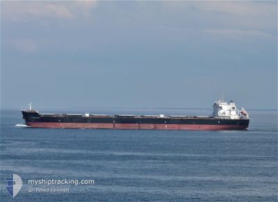
YANNIS GORGIAS
Bulk Carrier
Current Trip
| Time Travelled | --- |
|---|---|
| Remaining Time | --- |
| Distance Travelled | 5516.62 nm |
| Remaining Distance | --- |
| AVG Speed | 9.3 Knots |
| MAX Speed | 13.5 Knots |
| AVG Wind | 9.5 knots |
| MAX Wind | 31 knots |
| MIN Temp | 13.8°C / 56.84°F |
| MAX Temp | 29.4°C / 84.92°F |
| Draught | 6.3 m |
| Position Received | 9 h, 24 m ago |
Current Position
| Longitude | -48.27562° |
|---|---|
| Latitude | -25.74587° |
| Status | At anchor |
| Speed | 0.1 Knots |
| Course | 24° |
| Area | South Atlantic Ocean |
| Station | T-AIS |
| Position Received | 9 h, 24 m ago |
Info
Information
The current position of YANNIS GORGIAS is in South Atlantic Ocean with coordinates -25.74587° / -48.27562° as reported on 2025-02-04 23:05 by AIS to our vessel tracker app. The vessel's current speed is 0.1 Knots
The vessel YANNIS GORGIAS (IMO: 9423293, MMSI: 249944000) is a Bulk Carrier that was built in 2010 ( 15 years old ). It's sailing under the flag of [MT] Malta.
In this page you can find informations about the vessels current position, last detected port calls, and current voyage information. If the vessels is not in coverage by AIS you will find the latest position.
The current position of YANNIS GORGIAS is detected by our AIS receivers and we are not responsible for the reliability of the data. The last position was recorded while the vessel was in Coverage by the Ais receivers of our vessel tracking app.
The current draught of YANNIS GORGIAS as reported by AIS is 6.3 meters
Weather
| Temperature | 26.3°C / 79.34°F |
|---|---|
| Wind Speed | 10 knots |
| Direction | 355° N |
| Pressure | 1009.7 hPa |
| Humidity | 79.5 % |
| Cloud Coverage | 100 % |
Featured Company
Last Port Calls
Most Visited Ports (Last year)
| Port | Arrivals | |
|---|---|---|
| 1 | ||
| 1 | ||
| 1 | ||
| 1 | ||
| 1 | ||
| 1 |
Last Trips
| Origin | Departure | Destination | Arrival | Distance |
|---|
Events
| Time | Event | Details | Position / Dest | Info |
|---|---|---|---|---|
| 2025-02-04 23:08 | Status Changed | Default At anchor |
-25.74595 / -48.27560
MUPLU->BRPNG
|
Speed: 0.1 kn Course: 24° |
| 2025-02-04 23:05 | Status Changed | At anchor Default |
-25.74587 / -48.27562
MUPLU->BRPNG
|
Speed: 0.1 kn Course: 20° |
| 2025-02-04 23:05 | OUT of Coverage |
-25.74587 / -48.27562
South Atlantic Ocean
|
Speed: 0.1 kn Course: 295° |
|
| 2025-02-04 22:44 | Status Changed | Default At anchor |
-25.74590 / -48.27571
MUPLU->BRPNG
|
Speed: Course: 26° |
| 2025-02-04 22:35 | Status Changed | At anchor Default |
-25.74592 / -48.27553
MUPLU->BRPNG
|
Speed: 0.1 kn Course: 28° |
| 2025-02-04 22:34 | Draught Changed | 6.3 7.3 |
-25.74585 / -48.27564
MUPLU->BRPNG
|
Speed: 0.1 kn Course: 28° |
| 2025-02-04 22:29 | IN Coverage |
-25.74592 / -48.27553
South Atlantic Ocean
|
Speed: Course: 136° |
|
| 2025-02-04 21:35 | Status Changed | Default At anchor |
-25.74575 / -48.27588
MUPLU->BRPNG
|
Speed: Course: 29° |
| 2025-02-04 21:32 | OUT of Coverage |
-25.74583 / -48.27587
South Atlantic Ocean
|
Speed: Course: 282° |
|
| 2025-02-04 21:26 | Status Changed | At anchor Default |
-25.74583 / -48.27580
MUPLU->BRPNG
|
Speed: Course: 32° |