

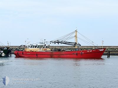
YE-19 JOHANNA-K
Fishing Vessel

Current Trip
| Trip Time | 11 h, 15 mins |
|---|---|
| Trip Distance | 28.28 nm |
| AVG Speed | 6.8 Knots |
| MAX Speed | 11.1 Knots |
| Draught | 1 m |
| AVG Wind | 12.6 knots |
| MAX Wind | 15 knots |
| MIN Temp | 9.6°C / 49.28°F |
| MAX Temp | 14.7°C / 58.46°F |
| Position Received | 12 m ago |
Current Position
| Longitude | 4.05576° |
|---|---|
| Latitude | 51.49965° |
| Status | Moored |
| Speed | |
| Course | 86° |
| Area | North Sea |
| Station | T-AIS |
| Position Received | 12 m ago |
Information
The current position of YE-19 JOHANNA-K is in North Sea with coordinates 51.49965° / 4.05576° as reported on 2025-06-11 01:55 by AIS to our vessel tracker app. The vessel's current speed is 0 Knots and is currently inside the port of YERSEKE.
The vessel YE-19 JOHANNA-K (IMO: 9129988, MMSI: 244368000) is a Fishing Vessel that was built in 1995 ( 30 years old ). It's sailing under the flag of [NL] Netherlands.
In this page you can find informations about the vessels current position, last detected port calls, and current voyage information. If the vessels is not in coverage by AIS you will find the latest position.
The current position of YE-19 JOHANNA-K is detected by our AIS receivers and we are not responsible for the reliability of the data. The last position was recorded while the vessel was in Coverage by the Ais receivers of our vessel tracking app.
The current draught of YE-19 JOHANNA-K as reported by AIS is 1 meters
Weather
| Temperature | 11°C / 51.8°F |
|---|---|
| Wind Speed | 4 knots |
| Direction | 29° NNE |
| Pressure | 1021.7 hPa |
| Humidity | 83.8 % |
| Cloud Coverage | 10 % |


Featured Company
Last Port Calls
| Port | Arrival | Departure | Time In Port |
|---|---|---|---|
| 2025-06-03 08:29 | |||
| 2025-06-02 20:59 | 2025-06-02 21:14 | 15 m | |
| 2025-05-28 13:00 | 2025-06-02 07:42 | 4 d | |
| 2025-05-22 18:30 | 2025-05-26 06:08 | 3 d | |
| 2025-05-22 12:28 | 2025-05-22 14:02 | 1 h | |
| 2025-05-21 18:46 | 2025-05-22 05:18 | 10 h | |
| 2025-05-21 17:48 | 2025-05-21 18:05 | 16 m | |
| 2025-05-15 13:14 | 2025-05-19 06:25 | 3 d | |
| 2025-05-14 18:01 | 2025-05-15 06:59 | 12 h | |
| 2025-05-14 15:27 | 2025-05-14 16:03 | 36 m |
Most Visited Ports (Last year)
| Port | Arrivals | |
|---|---|---|
| 66 | ||
| 23 | ||
| 20 | ||
| 8 | ||
| 7 | ||
| 6 |
Last Trips
| Origin | Departure | Destination | Arrival | Distance | |
|---|---|---|---|---|---|
| 2025-06-02 21:14 | 2025-06-03 08:29 | 28.28 nm | |||
| 2025-06-02 07:42 | 2025-06-02 20:59 | 121.97 nm | |||
| 2025-05-26 06:08 | 2025-05-28 13:00 | 178.57 nm | |||
| 2025-05-22 14:02 | 2025-05-22 18:30 | 28.56 nm | |||
| 2025-05-22 05:18 | 2025-05-22 12:28 | 29.60 nm | |||
| 2025-05-21 18:05 | 2025-05-21 18:46 | 1.83 nm | |||
| 2025-05-19 06:25 | 2025-05-21 17:48 | 129.45 nm | |||
| 2025-05-15 06:59 | 2025-05-15 13:14 | 29.11 nm | |||
| 2025-05-14 16:03 | 2025-05-14 18:01 | 8.82 nm | |||
| 2025-05-12 05:41 | 2025-05-14 15:27 | 157.04 nm |
Events
| Time | Event | Details | Position / Dest | Info |
|---|---|---|---|---|
| 2025-06-10 20:07 | IN Coverage |
51.49964 / 4.05574
North Sea
[NL] YERSEKE
|
Speed: Course: 296° |
|
| 2025-06-10 18:58 | OUT of Coverage |
51.49965 / 4.05575
North Sea
[NL] YERSEKE
|
Speed: Course: 296° |
|
| 2025-06-09 14:16 | IN Coverage |
51.49965 / 4.05577
North Sea
[NL] YERSEKE
|
Speed: Course: 343.7° |
|
| 2025-06-09 11:40 | OUT of Coverage |
51.49966 / 4.05575
North Sea
[NL] YERSEKE
|
Speed: Course: 251.2° |
|
| 2025-06-08 20:52 | IN Coverage |
51.49959 / 4.05579
North Sea
[NL] YERSEKE
|
Speed: Course: 79.1° |
|
| 2025-06-08 18:19 | OUT of Coverage |
51.49965 / 4.05574
North Sea
[NL] YERSEKE
|
Speed: Course: 211.6° |
|
| 2025-06-08 15:52 | IN Coverage |
51.49967 / 4.05574
North Sea
[NL] YERSEKE
|
Speed: Course: 21.1° |
|
| 2025-06-08 14:46 | OUT of Coverage |
51.49965 / 4.05574
North Sea
[NL] YERSEKE
|
Speed: Course: 21.1° |
|
| 2025-06-08 14:46 | IN Coverage |
51.49965 / 4.05574
North Sea
[NL] YERSEKE
|
Speed: Course: 21.1° |
|
| 2025-06-08 11:22 | OUT of Coverage |
51.49966 / 4.05575
North Sea
[NL] YERSEKE
|
Speed: Course: 258.7° |