
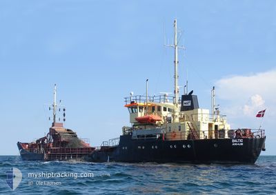
BALTIC
Suction Hopper Dredger
Current Trip
| Time Travelled | 1 day |
|---|---|
| Remaining Time | -1 mins |
| Distance Travelled | 110.57 nm |
| Remaining Distance | 4.99 nm |
| AVG Speed | 6.1 Knots |
| MAX Speed | 8.9 Knots |
| AVG Wind | 15.5 knots |
| MAX Wind | 19 knots |
| MIN Temp | -1°C / 30.2°F |
| MAX Temp | 2.1°C / 35.78°F |
| Dybgang | 4.5 m |
| Position Modtaget | 1 m siden |
Current Position
| Longitude | 12.35466° |
|---|---|
| Latitude | 55.54161° |
| Status | Under way using engine |
| Fart | 1.6 Knots |
| Kurs | 335° |
| Område | Kattegat |
| Station | T-AIS |
| Position Modtaget | 1 m siden |
Info
Information
The current position of BALTIC is in Kattegat with coordinates 55.54161° / 12.35466° as reported on 2025-02-14 05:30 by AIS to our vessel tracker app. The vessel's current speed is 1.6 Knots and is heading at the port of AVEDORE. The estimated time of arrival as calculated by MyShipTracking vessel tracking app is 2025-02-14 06:30 LT
The vessel BALTIC (IMO: 8400048, MMSI: 219000195) is a Suction Hopper Dredger that was built in 1983 ( 42 år gamle ). It's sailing under the flag of [DK] Denmark.
In this page you can find informations about the vessels current position, last detected port calls, and current voyage information. If the vessels is not in coverage by AIS you will find the latest position.
The current position of BALTIC is detected by our AIS receivers and we are not responsible for the reliability of the data. The last position was recorded while the vessel was in Coverage by the Ais receivers of our vessel tracking app.
The current draught of BALTIC as reported by AIS is 4.5 meters
Weather
| Temperature | -2°C / 28.4°F |
|---|---|
| Wind Speed | 8 knots |
| Direction | 35° NE |
| Pressure | 1025.9 hPa |
| Humidity | 75.5 % |
| Cloud Coverage | 48 % |
Featured Company
Last Port Calls
| Port | Arrival | Departure | Time In Port |
|---|---|---|---|
| 2025-02-10 17:19 | 2025-02-12 13:49 | 1 d | |
| 2025-02-09 13:11 | 2025-02-10 06:50 | 17 h | |
| 2025-02-08 11:57 | 2025-02-09 09:59 | 22 h | |
| 2025-02-07 16:46 | 2025-02-08 07:48 | 15 h | |
| 2025-02-06 23:46 | 2025-02-07 10:10 | 10 h | |
| 2025-02-06 13:56 | 2025-02-06 18:21 | 4 h | |
| 2025-02-05 16:52 | 2025-02-06 10:44 | 17 h | |
| 2025-02-05 09:23 | 2025-02-05 13:58 | 4 h | |
| 2025-02-04 15:33 | 2025-02-05 06:18 | 14 h | |
| 2025-02-03 11:44 | 2025-02-03 12:02 | 17 m |
Most Visited Ports (Last year)
| Port | Arrivals | |
|---|---|---|
| 130 | ||
| 70 | ||
| 18 | ||
| 15 | ||
| 4 | ||
| 1 |
Last Trips
| Origin | Departure | Destination | Arrival | Distance | |
|---|---|---|---|---|---|
| 2025-02-10 06:50 | 2025-02-10 17:19 | 35.75 nm | |||
| 2025-02-09 09:59 | 2025-02-09 13:11 | 7.45 nm | |||
| 2025-02-08 07:48 | 2025-02-08 11:57 | 9.64 nm | |||
| 2025-02-07 10:10 | 2025-02-07 16:46 | 13.53 nm | |||
| 2025-02-06 18:21 | 2025-02-06 23:46 | 10.44 nm | |||
| 2025-02-06 10:44 | 2025-02-06 13:56 | 5.87 nm | |||
| 2025-02-05 13:58 | 2025-02-05 16:52 | 5.52 nm | |||
| 2025-02-05 06:18 | 2025-02-05 09:23 | 6.91 nm | |||
| 2025-02-03 12:02 | 2025-02-04 15:33 | 48.62 nm | |||
| 2025-02-03 09:39 | 2025-02-03 11:44 | 14.45 nm |
Events
| Tid | Hændelsen | Detaljer | Position / Dest | Info |
|---|---|---|---|---|
| 2025-02-14 05:03 | STOP Sejllads | 5.72 nm, South West of AVEDORE |
55.54141 / 12.35496
AVEDOERE
|
Fart: 0.3 kn Kurs: 77° |
| 2025-02-14 04:09 | START Sejllads | 0.91 nm, South of AVEDORE |
55.58476 / 12.49868
AVEDOERE
|
Fart: 3.1 kn Kurs: 191° |
| 2025-02-14 03:27 | STOP Sejllads | 0.64 nm, North East of AVEDORE |
55.60352 / 12.50562
AVEDOERE
|
Fart: 0.3 kn Kurs: 12° |
| 2025-02-14 02:18 | ETA er ændret | 2025/02/14 03:00 2025/02/13 19:00 |
55.56850 / 12.49217
AVEDOERE
|
Fart: 6 kn Kurs: 11.3° |
| 2025-02-14 01:42 | START Sejllads | 4.24 nm, South West of AVEDORE |
55.53992 / 12.42024
AVEDOERE
|
Fart: 3.1 kn Kurs: 77° |
| 2025-02-13 23:30 | STOP Sejllads | 3.67 nm, South of AVEDORE |
55.54079 / 12.45509
AVEDOERE
|
Fart: 0.3 kn Kurs: 99° |
| 2025-02-13 22:31 | START Sejllads | 5.63 nm, South West of AVEDORE |
55.54162 / 12.35777
AVEDOERE
|
Fart: 3.3 kn Kurs: 84° |
| 2025-02-13 21:26 | STOP Sejllads | 5.71 nm, South West of AVEDORE |
55.54191 / 12.35443
AVEDOERE
|
Fart: 0.2 kn Kurs: 5° |
| 2025-02-13 20:37 | START Sejllads | 0.85 nm, South East of AVEDORE |
55.58598 / 12.49881
AVEDOERE
|
Fart: 3.2 kn Kurs: 189° |
| 2025-02-13 18:52 | STOP Sejllads | 0.73 nm, South East of AVEDORE |
55.58835 / 12.49969
AVEDOERE
|
Fart: 0.3 kn Kurs: 13° |