

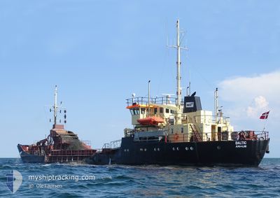
BALTIC
Suction Hopper Dredger

Current Trip
| Trip Time | 3 h, 0 mins |
|---|---|
| Trip Distance | 6.83 nm |
| AVG Speed | 3.6 Knots |
| MAX Speed | 7.3 Knots |
| Draught | 4.5 m |
| AVG Wind | 16.1 knots |
| MAX Wind | 16.9 knots |
| MIN Temp | 9.4°C / 48.92°F |
| MAX Temp | 10°C / 50°F |
| Position Received | 1 m ago |
Current Position
| Longitude | 12.20262° |
|---|---|
| Latitude | 55.46193° |
| Status | Under way using engine |
| Speed | |
| Course | 359° |
| Area | Kattegat |
| Station | T-AIS |
| Position Received | 1 m ago |
Information
The current position of BALTIC is in Kattegat with coordinates 55.46193° / 12.20262° as reported on 2025-05-23 20:56 by AIS to our vessel tracker app. The vessel's current speed is 0 Knots and is currently inside the port of KOEGE.
The vessel BALTIC (IMO: 8400048, MMSI: 219000195) is a Suction Hopper Dredger that was built in 1983 ( 42 years old ). It's sailing under the flag of [DK] Denmark.
In this page you can find informations about the vessels current position, last detected port calls, and current voyage information. If the vessels is not in coverage by AIS you will find the latest position.
The current position of BALTIC is detected by our AIS receivers and we are not responsible for the reliability of the data. The last position was recorded while the vessel was in Coverage by the Ais receivers of our vessel tracking app.
The current draught of BALTIC as reported by AIS is 4.5 meters
Weather
| Temperature | 8.1°C / 46.58°F |
|---|---|
| Wind Speed | 10 knots |
| Direction | 263° W |
| Pressure | 1010 hPa |
| Humidity | 78.1 % |
| Cloud Coverage | 100 % |


Featured Company
Last Port Calls
| Port | Arrival | Departure | Time In Port |
|---|---|---|---|
| 2025-05-23 12:34 | |||
| 2025-05-21 15:29 | 2025-05-23 09:34 | 1 d | |
| 2025-05-20 20:57 | 2025-05-21 11:57 | 15 h | |
| 2025-05-19 18:39 | 2025-05-20 18:07 | 23 h | |
| 2025-05-18 14:09 | 2025-05-19 15:25 | 1 d | |
| 2025-05-17 19:12 | 2025-05-18 09:53 | 14 h | |
| 2025-05-16 17:13 | 2025-05-17 10:14 | 17 h | |
| 2025-05-15 20:13 | 2025-05-16 09:48 | 13 h | |
| 2025-05-15 11:43 | 2025-05-15 17:41 | 5 h | |
| 2025-05-14 19:45 | 2025-05-15 09:17 | 13 h |
Most Visited Ports (Last year)
| Port | Arrivals | |
|---|---|---|
| 207 | ||
| 122 | ||
| 18 | ||
| 17 | ||
| 3 | ||
| 1 |
Last Trips
| Origin | Departure | Destination | Arrival | Distance | |
|---|---|---|---|---|---|
| 2025-05-23 09:34 | 2025-05-23 12:34 | 6.83 nm | |||
| 2025-05-21 11:57 | 2025-05-21 15:29 | 8.05 nm | |||
| 2025-05-20 18:07 | 2025-05-20 20:57 | 6.29 nm | |||
| 2025-05-19 15:25 | 2025-05-19 18:39 | 8.02 nm | |||
| 2025-05-18 09:53 | 2025-05-18 14:09 | 7.85 nm | |||
| 2025-05-17 10:14 | 2025-05-17 19:12 | 15.46 nm | |||
| 2025-05-16 09:48 | 2025-05-16 17:13 | 12.78 nm | |||
| 2025-05-15 17:41 | 2025-05-15 20:13 | 6.52 nm | |||
| 2025-05-15 09:17 | 2025-05-15 11:43 | 6.50 nm | |||
| 2025-05-14 17:07 | 2025-05-14 19:45 | 7.25 nm |
Events
| Time | Event | Details | Position / Dest | Info |
|---|---|---|---|---|
| 2025-05-23 10:43 | STOP Moving |
55.46190 / 12.20261
[DK] KOEGE
|
Speed: 0.3 kn Course: 2° |
|
| 2025-05-23 10:34 | PORT ARRIVAL |
|
55.45760 / 12.21003
[DK] KOEGE
|
Speed: 6 kn Course: 263.9° |
| 2025-05-23 10:21 | START Moving | 1.37 nm, South East of KOEGE |
55.44507 / 12.23820
KOEGE
|
Speed: 3.3 kn Course: 330° |
| 2025-05-23 08:25 | STOP Moving | 1.73 nm, South East of KOEGE |
55.43941 / 12.24454
KOEGE
|
Speed: 0.3 kn Course: 303° |
| 2025-05-23 07:34 | PORT DEPARTURE |
|
55.45730 / 12.21319
KOEGE
|
Speed: 7.1 kn Course: 130° |
| 2025-05-23 07:32 | ETA Changed | 2025/05/23 12:00 2025/05/20 21:00 |
55.45766 / 12.20740
[DK] KOEGE
|
Speed: 6.7 kn Course: 92° |
| 2025-05-23 07:30 | START Moving |
55.45974 / 12.20421
[DK] KOEGE
|
Speed: 6.1 kn Course: 185° |
|
| 2025-05-21 13:38 | STOP Moving |
55.46159 / 12.20303
[DK] KOEGE
|
Speed: 0.3 kn Course: 357° |
|
| 2025-05-21 13:29 | PORT ARRIVAL |
|
55.45765 / 12.20991
[DK] KOEGE
|
Speed: 6.2 kn Course: 266.3° |
| 2025-05-21 13:14 | START Moving | 1.56 nm, South East of KOEGE |
55.44167 / 12.24099
KOEGE
|
Speed: 3.1 kn Course: 309° |