
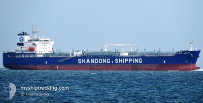
CL EMILY BRONTE
Tanker
Current Trip
| Time Travelled | 1 day |
|---|---|
| Remaining Time | 18 days |
| Distance Travelled | 275.61 nm |
| Remaining Distance | 6106.23 nm |
| AVG Speed | 11.8 Knots |
| MAX Speed | 14.4 Knots |
| AVG Wind | 7 knots |
| MAX Wind | 9.9 knots |
| MIN Temp | 24.1°C / 75.38°F |
| MAX Temp | 29.2°C / 84.56°F |
| Dybgang | 11.4 m |
| Position Modtaget | 21 h, 20 m siden |
Current Position
| Longitude | 103.56070° |
|---|---|
| Latitude | 1.19172° |
| Status | Under way using engine |
| Fart | 14.1 Knots |
| Kurs | 277° |
| Område | Singapore Strait |
| Station | T-AIS |
| Position Modtaget | 21 h, 20 m siden |
Info
Information
The current position of CL EMILY BRONTE is in Singapore Strait with coordinates 1.19172° / 103.56070° as reported on 2025-02-11 20:59 by AIS to our vessel tracker app. The vessel's current speed is 14.1 Knots and is heading at the port of WALVIS BAY. The estimated time of arrival as calculated by MyShipTracking vessel tracking app is 2025-03-03 19:37 LT
The vessel CL EMILY BRONTE (IMO: 9943322, MMSI: 636022160) is a Tanker It's sailing under the flag of [LR] Liberia.
In this page you can find informations about the vessels current position, last detected port calls, and current voyage information. If the vessels is not in coverage by AIS you will find the latest position.
The current position of CL EMILY BRONTE is detected by our AIS receivers and we are not responsible for the reliability of the data. The last position was recorded while the vessel was in Coverage by the Ais receivers of our vessel tracking app.
The current draught of CL EMILY BRONTE as reported by AIS is 11.4 meters
Weather
| Temperature | 28.3°C / 82.94°F |
|---|---|
| Wind Speed | 3 knots |
| Direction | 261° W |
| Pressure | 1010.8 hPa |
| Humidity | 70.6 % |
| Cloud Coverage | 9 % |
Featured Company
Last Port Calls
| Port | Arrival | Departure | Time In Port |
|---|---|---|---|
| 2025-02-10 09:32 | 2025-02-12 00:28 | 1 d | |
| 2025-01-12 16:24 | 2025-01-25 07:42 | 12 d |
Most Visited Ports (Last year)
| Port | Arrivals | |
|---|---|---|
| 3 | ||
| 2 | ||
| 2 | ||
| 2 | ||
| 2 | ||
| 1 |
Last Trips
| Origin | Departure | Destination | Arrival | Distance | |
|---|---|---|---|---|---|
| 2025-01-25 07:42 | 2025-02-10 09:32 | 2823.76 nm | |||
| 2024-11-23 02:22 | 2025-01-12 16:24 | 11569.16 nm |
Events
| Tid | Hændelsen | Detaljer | Position / Dest | Info |
|---|---|---|---|---|
| 2025-02-11 21:05 | Status er ændret | Default Under way using engine |
1.19642 / 103.53814
NA WVB
|
Fart: 14.1 kn Kurs: 277° |
| 2025-02-11 20:59 | Udenfor Dækning |
1.19172 / 103.56070
Singapore Strait
NA WVB
|
Fart: 14.1 kn Kurs: 277° |
|
| 2025-02-11 20:55 | Ændre havområde | Malaysian part of the Singapore Strait Indonesian part of the Singapore Strait |
1.18985 / 103.57836
Singapore Strait
NA WVB
|
Fart: 14.3 kn Kurs: 275.7° |
| 2025-02-11 20:55 | Status er ændret | Under way using engine Default |
1.18976 / 103.57919
NA WVB
|
Fart: 14.5 kn Kurs: 274° |
| 2025-02-11 20:49 | Status er ændret | Default Under way using engine |
1.18792 / 103.60038
NA WVB
|
Fart: 14.5 kn Kurs: 275.5° |
| 2025-02-11 20:10 | Ændre havområde | Indonesian part of the Singapore Strait Singaporean part of the Singapore Strait |
1.13421 / 103.73510
Singapore Strait
NA WVB
|
Fart: 13.3 kn Kurs: 270.7° |
| 2025-02-11 18:31 | Ændre havområde | Singaporean part of the Singapore Strait Malaysian part of the Singapore Strait |
1.27314 / 104.05195
Singapore Strait
NA WVB
|
Fart: 13.3 kn Kurs: 260.1° |
| 2025-02-11 17:33 | Ændre havområde | Malaysian part of the Singapore Strait Singaporean part of the Singapore Strait |
1.35600 / 104.05092
Singapore Strait
NA WVB
|
Fart: 7.5 kn Kurs: 129.8° |
| 2025-02-11 16:43 | Ændre havområde | Singaporean part of the Singapore Strait Malaysian part of the Singapore Strait |
1.41148 / 103.93019
Singapore Strait
NA WVB
|
Fart: 9.5 kn Kurs: 130.8° |
| 2025-02-11 16:28 | Afsejlet fra sidste havn |
|
1.42888 / 103.90601
NA WVB
|
Fart: 3.9 kn Kurs: 116° |