
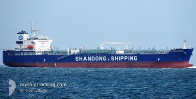
CL EMILY BRONTE
Tanker
Current Trip
| Time Travelled | 14 days |
|---|---|
| Remaining Time | 11 h, 36 mins |
| Distance Travelled | 2757.20 морская миля |
| Remaining Distance | 132.35 морская миля |
| AVG Speed | 12 Узлы |
| MAX Speed | 15.1 Узлы |
| AVG Wind | 12.5 knots |
| MAX Wind | 26 knots |
| MIN Temp | 22.1°C / 71.78°F |
| MAX Temp | 28.8°C / 83.84°F |
| Осадка | 9 м |
| Позиция Получена | Сейчас |
Current Position
| Долгота | 103.60306° |
|---|---|
| Широта | 1.08018° |
| Статус | Under way using engine |
| Скорость | 11.4 Узлы |
| Курс | 108.4° |
| Район | Singapore Strait |
| Станция | T-AIS |
| Позиция Получена | Сейчас |
Info
Information
The current position of CL EMILY BRONTE is in Singapore Strait with coordinates 1.08018° / 103.60306° as reported on 2025-02-08 04:00 by AIS to our vessel tracker app. The vessel's current speed is 11.4 Узлы and is heading at the port of DUMAI. The estimated time of arrival as calculated by MyShipTracking vessel tracking app is 2025-02-08 15:37 LT
The vessel CL EMILY BRONTE (IMO: 9943322, MMSI: 636022160) is a Tanker It's sailing under the flag of [LR] Liberia.
In this page you can find informations about the vessels current position, last detected port calls, and current voyage information. If the vessels is not in coverage by AIS you will find the latest position.
The current position of CL EMILY BRONTE is detected by our AIS receivers and we are not responsible for the reliability of the data. The last position was recorded while the vessel was in Coverage by the Ais receivers of our vessel tracking app.
The current draught of CL EMILY BRONTE as reported by AIS is 9 meters
Weather
| Temperature | 26.1°C / 78.98°F |
|---|---|
| Wind Speed | 11 knots |
| Direction | 15° NNE |
| Pressure | 1012.1 hPa |
| Humidity | 80.9 % |
| Cloud Coverage | 95 % |
Featured Company
Most Visited Ports (Last year)
| Port | Arrivals | |
|---|---|---|
| 3 | ||
| 2 | ||
| 2 | ||
| 2 | ||
| 1 | ||
| 1 |
Last Trips
| Origin | Departure | Destination | Arrival | Distance | |
|---|---|---|---|---|---|
| 2024-11-23 02:22 | 2025-01-12 16:24 | 11569.16 морская миля |
Events
| Время | Событие | Детали | Позиция / Направление | Информация |
|---|---|---|---|---|
| 2025-02-08 02:58 | Изменение морского района | Indonesian part of the Singapore Strait Indonesian part of the Malacca Strait |
1.18424 / 103.43448
Singapore Strait
|
Скорость: 11.4 kn Курс: 113.9° |
| 2025-02-08 02:49 | Изменение морского района | Indonesian part of the Malacca Strait Malaysian part of the Malacca Strait |
1.19515 / 103.40987
Malacca Strait
|
Скорость: 11.2 kn Курс: 113.3° |
| 2025-02-08 02:49 | Статус изменился | Under way using engine Default |
1.19615 / 103.40752
ID DUM
|
Скорость: 11.2 kn Курс: 119° |
| 2025-02-08 02:41 | В покрытии |
1.19515 / 103.40987
Malacca Strait
|
Скорость: 11.2 kn Курс: 113.3° |
|
| 2025-02-07 12:22 | Начало движения | 6.53 nm, North West of DUMAI |
1.75881 / 101.37365
ID DUM
|
Скорость: 5.6 kn Курс: 124° |
| 2025-02-02 15:45 | Окончание движения | 6.56 nm, North West of DUMAI |
1.75545 / 101.37051
ID DUM
|
Скорость: 0.3 kn Курс: 318° |
| 2025-02-02 14:53 | Начало движения | 2.65 nm, North West of DUMAI |
1.72285 / 101.42900
ID DUM
|
Скорость: 5.6 kn Курс: 286° |
| 2025-02-02 07:25 | Окончание движения | 2.69 nm, North West of DUMAI |
1.72446 / 101.43015
ID DUM
|
Скорость: 0.3 kn Курс: 103° |
| 2025-02-01 14:57 | Статус изменился | Default Under way using engine |
1.26141 / 103.39246
ID DUM
|
Скорость: 11.2 kn Курс: 304.9° |
| 2025-02-01 14:52 | Вне покрытия |
1.25199 / 103.40602
Malacca Strait
ID DUM
|
Скорость: 11.2 kn Курс: 304.9° |