
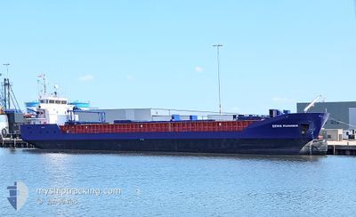
EEMS RUNNER
General Cargo
Current Trip
| Trip Time | 4 days |
|---|---|
| Trip Distance | 923.70 nm |
| AVG Speed | 7.9 Knots |
| MAX Speed | 13.8 Knots |
| Dybgang | 6.1 m |
| AVG Wind | 15 knots |
| MAX Wind | 34 knots |
| MIN Temp | 3.8°C / 38.84°F |
| MAX Temp | 12.3°C / 54.14°F |
| Position Modtaget | 1 d siden |
Current Position
| Longitude | -8.78063° |
|---|---|
| Latitude | 42.59749° |
| Status | Under way using engine |
| Fart | 1.9 Knots |
| Kurs | 203° |
| Område | North Atlantic Ocean |
| Station | T-AIS |
| Position Modtaget | 1 d siden |
Info
Information
The current position of EEMS RUNNER is in North Atlantic Ocean with coordinates 42.59749° / -8.78063° as reported on 2025-02-04 05:56 by AIS to our vessel tracker app. The vessel's current speed is 1.9 Knots and is currently inside the port of VILLAGARCIA.
The vessel EEMS RUNNER (IMO: 9259056, MMSI: 244002000) is a General Cargo that was built in 2003 ( 22 år gamle ). It's sailing under the flag of [NL] Netherlands.
In this page you can find informations about the vessels current position, last detected port calls, and current voyage information. If the vessels is not in coverage by AIS you will find the latest position.
The current position of EEMS RUNNER is detected by our AIS receivers and we are not responsible for the reliability of the data. The last position was recorded while the vessel was in Coverage by the Ais receivers of our vessel tracking app.
The current draught of EEMS RUNNER as reported by AIS is 6.1 meters
Weather
| Temperature | 5.9°C / 42.62°F |
|---|---|
| Wind Speed | 4 knots |
| Direction | 57° ENE |
| Pressure | 1033.9 hPa |
| Humidity | 90.4 % |
| Cloud Coverage | 45 % |
Featured Company
Last Port Calls
| Port | Arrival | Departure | Time In Port |
|---|---|---|---|
| 2025-02-04 06:45 | |||
| 2025-01-31 00:09 | 2025-01-31 00:18 | 8 m | |
| 2025-01-30 06:24 | |||
| 2025-01-26 19:19 | 2025-01-28 15:57 | 1 d | |
| 2025-01-22 12:11 | 2025-01-26 00:23 | 3 d | |
| 2025-01-19 14:34 | 2025-01-21 15:32 | 2 d | |
| 2025-01-18 11:28 | 2025-01-19 14:19 | 1 d | |
| 2025-01-15 08:35 | 2025-01-17 20:25 | 2 d | |
| 2025-01-12 10:30 | 2025-01-14 16:01 | 2 d | |
| 2025-01-10 08:25 | 2025-01-11 17:32 | 1 d |
Most Visited Ports (Last year)
| Port | Arrivals | |
|---|---|---|
| 9 | ||
| 8 | ||
| 5 | ||
| 5 | ||
| 4 | ||
| 4 |
Last Trips
| Origin | Departure | Destination | Arrival | Distance | |
|---|---|---|---|---|---|
| 2025-01-31 00:18 | 2025-02-04 06:45 | 923.70 nm | |||
| 2025-01-28 15:57 | 2025-01-31 00:09 | 408.99 nm | |||
| 2025-01-28 15:57 | 2025-01-30 06:24 | 408.83 nm | |||
| 2025-01-26 00:23 | 2025-01-26 19:19 | 165.01 nm | |||
| 2025-01-21 15:32 | 2025-01-22 12:11 | 160.31 nm | |||
| 2025-01-17 20:25 | 2025-01-19 14:34 | 163.26 nm | |||
| 2025-01-17 20:25 | 2025-01-18 11:28 | 158.25 nm | |||
| 2025-01-14 16:01 | 2025-01-15 08:35 | 157.87 nm | |||
| 2025-01-11 17:32 | 2025-01-12 10:30 | 156.89 nm | |||
| 2025-01-09 15:06 | 2025-01-10 08:25 | 133.86 nm |
Events
| Tid | Hændelsen | Detaljer | Position / Dest | Info |
|---|---|---|---|---|
| 2025-02-04 06:14 | Status er ændret | Default Under way using engine |
42.59570 / -8.78081
[ES] VILLAGARCIA
|
Fart: 1.9 kn Kurs: 203° |
| 2025-02-04 06:14 | STOP Sejllads |
42.59570 / -8.78081
[ES] VILLAGARCIA
|
Fart: Kurs: 105° |
|
| 2025-02-04 05:56 | Status er ændret | Under way using engine Default |
42.59749 / -8.78063
[ES] VILLAGARCIA
|
Fart: 5.4 kn Kurs: 89° |
| 2025-02-04 05:56 | Udenfor Dækning |
42.59749 / -8.78063
North Atlantic Ocean
[ES] VILLAGARCIA
|
Fart: 1.9 kn Kurs: 254.8° |
|
| 2025-02-04 05:45 | Skibe i havn |
|
42.60118 / -8.78608
[ES] VILLAGARCIA
|
Fart: 8.3 kn Kurs: 72° |
| 2025-02-04 05:40 | Status er ændret | Default Under way using engine |
42.59877 / -8.79869
VILAGARCIA
|
Fart: 8 kn Kurs: 72° |
| 2025-02-04 05:20 | Status er ændret | Under way using engine Default |
42.58800 / -8.85314
VILAGARCIA
|
Fart: 8.5 kn Kurs: 77° |
| 2025-02-04 05:19 | Status er ændret | Default Under way using engine |
42.58765 / -8.85525
VILAGARCIA
|
Fart: 8.6 kn Kurs: 76.3° |
| 2025-02-04 03:57 | ETA er ændret | 2025/02/04 06:30 2025/02/03 23:00 |
42.44699 / -9.01271
VILAGARCIA
|
Fart: 8.6 kn Kurs: 100.7° |
| 2025-02-04 03:35 | Ændre havområde | Spanish part of the North Atlantic Ocean French part of the Celtic Sea |
42.46774 / -9.07548
North Atlantic Ocean
VILAGARCIA
|
Fart: 8 kn Kurs: 104.8° |