

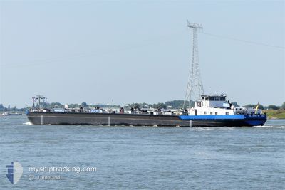
EILTANK 19
Tanker D

Current Trip
Current Position
| Longitude | 7.65838° |
|---|---|
| Latitude | 47.54516° |
| Status | Under way using engine |
| Fart | |
| Kurs | --- |
| Område | North Sea |
| Station | T-AIS |
| Position Modtaget | 5 m siden |
Information
The current position of EILTANK 19 is in North Sea with coordinates 47.54516° / 7.65838° as reported on 2025-04-01 19:54 by AIS to our vessel tracker app. The vessel's current speed is 0 Knots and is currently inside the port of AUHAFEN.
The vessel EILTANK 19 (MMSI: 211486580) is a Tanker D It's sailing under the flag of [DE] Germany.
In this page you can find informations about the vessels current position, last detected port calls, and current voyage information. If the vessels is not in coverage by AIS you will find the latest position.
The current position of EILTANK 19 is detected by our AIS receivers and we are not responsible for the reliability of the data. The last position was recorded while the vessel was in Coverage by the Ais receivers of our vessel tracking app.
The current draught of EILTANK 19 as reported by AIS is 2.3 meters
Weather
| Temperature | 6.2°C / 43.16°F |
|---|---|
| Wind Speed | 15 knots |
| Direction | 83° E |
| Pressure | 1015.4 hPa |
| Humidity | 71.1 % |
| Cloud Coverage | 99 % |


Featured Company
Last Port Calls
| Port | Arrival | Departure | Time In Port |
|---|---|---|---|
| 2025-04-01 19:16 | |||
| 2025-03-31 04:07 | 2025-03-31 04:22 | 15 m | |
| 2025-03-25 13:39 | 2025-03-28 09:46 | 2 d | |
| 2025-03-23 13:10 | 2025-03-24 04:56 | 15 h | |
| 2025-03-22 12:58 | 2025-03-22 13:17 | 18 m | |
| 2025-03-21 15:40 | 2025-03-22 12:22 | 20 h | |
| 2025-03-21 14:26 | 2025-03-21 14:56 | 30 m | |
| 2025-03-20 10:24 | |||
| 2025-03-17 14:48 | 2025-03-17 15:09 | 20 m | |
| 2025-03-16 13:12 | 2025-03-17 14:15 | 1 d |
Last Trips
| Origin | Departure | Destination | Arrival | Distance | |
|---|---|---|---|---|---|
| 2025-03-31 06:22 | 2025-04-01 21:16 | 133.77 nm | |||
| 2025-03-28 10:46 | 2025-03-31 06:07 | 177.76 nm | |||
| 2025-03-24 05:56 | 2025-03-25 14:39 | 206.37 nm | |||
| 2025-03-22 14:17 | 2025-03-23 14:10 | 99.65 nm | |||
| 2025-03-22 13:22 | 2025-03-22 13:58 | 2.61 nm | |||
| 2025-03-21 15:56 | 2025-03-21 16:40 | 1.81 nm | |||
| 2025-03-20 11:24 | 2025-03-21 15:26 | 98.89 nm | |||
| 2025-03-17 15:15 | 2025-03-17 15:48 | 2.00 nm | |||
| 2025-03-15 04:17 | 2025-03-16 14:12 | 104.27 nm | |||
| 2025-03-12 17:31 | 2025-03-14 11:07 | 100.74 nm |
Events
| Tid | Hændelsen | Detaljer | Position / Dest | Info |
|---|---|---|---|---|
| 2025-04-01 19:20 | STOP Sejllads |
47.54519 / 7.65831
[CH] AUHAFEN
|
Fart: 0.3 kn Kurs: 511° |
|
| 2025-04-01 19:16 | Skibe i havn |
|
47.54619 / 7.65368
[CH] AUHAFEN
|
Fart: 4.7 kn Kurs: 117.2° |
| 2025-04-01 19:03 | START Sejllads | 0.41 nm, North West of BIRSFELDEN |
47.55897 / 7.63206
NACH HAUSE
|
Fart: 3.3 kn Kurs: 86.4° |
| 2025-04-01 18:51 | Status er ændret | Under way using engine Default |
47.55867 / 7.62862
NACH HAUSE
|
Fart: Kurs: -1° |
| 2025-04-01 18:31 | Status er ændret | Default Under way using engine |
47.55867 / 7.62862
NACH HAUSE
|
Fart: Kurs: 511° |
| 2025-04-01 18:29 | STOP Sejllads | 0.54 nm, West of BIRSFELDEN |
47.55867 / 7.62862
NACH HAUSE
|
Fart: Kurs: 511° |
| 2025-04-01 17:09 | START Sejllads | 4.04 nm, North West of HUNINGUE |
47.65120 / 7.52729
NACH HAUSE
|
Fart: 4.9 kn Kurs: 141.6° |
| 2025-04-01 16:38 | STOP Sejllads | 4.17 nm, North West of HUNINGUE |
47.65282 / 7.52532
NACH HAUSE
|
Fart: Kurs: 511° |
| 2025-04-01 16:33 | START Sejllads | 4.32 nm, North West of HUNINGUE |
47.65488 / 7.52314
NACH HAUSE
|
Fart: 3.2 kn Kurs: 143.4° |
| 2025-04-01 15:57 | STOP Sejllads | 4.45 nm, North West of HUNINGUE |
47.65653 / 7.52109
NACH HAUSE
|
Fart: Kurs: 511° |