

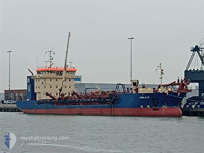
EMBLA R
Dredging or underwater ops

Current Trip
| Time Travelled | 6 h, 19 mins |
|---|---|
| Remaining Time | --- |
| Distance Travelled | 51.60 nm |
| Remaining Distance | --- |
| AVG Speed | 9.9 Knots |
| MAX Speed | 11.6 Knots |
| AVG Wind | 7.1 knots |
| MAX Wind | 8.3 knots |
| MIN Temp | 4°C / 39.2°F |
| MAX Temp | 5.9°C / 42.62°F |
| Dybgang | 5.1 m |
| Position Modtaget | 1 m siden |
Current Position
| Longitude | 12.74931° |
|---|---|
| Latitude | 55.15534° |
| Status | Under way using engine |
| Fart | 9.6 Knots |
| Kurs | 323.7° |
| Område | Baltic Sea |
| Station | T-AIS |
| Position Modtaget | 1 m siden |
Information
The current position of EMBLA R is in Baltic Sea with coordinates 55.15534° / 12.74931° as reported on 2025-04-10 11:28 by AIS to our vessel tracker app. The vessel's current speed is 9.6 Knots
The vessel EMBLA R (IMO: 9896048, MMSI: 219027309) is a Dredging or underwater ops It's sailing under the flag of [DK] Denmark.
In this page you can find informations about the vessels current position, last detected port calls, and current voyage information. If the vessels is not in coverage by AIS you will find the latest position.
The current position of EMBLA R is detected by our AIS receivers and we are not responsible for the reliability of the data. The last position was recorded while the vessel was in Coverage by the Ais receivers of our vessel tracking app.
The current draught of EMBLA R as reported by AIS is 5.1 meters
Weather
| Temperature | 5.8°C / 42.44°F |
|---|---|
| Wind Speed | 5 knots |
| Direction | 243° WSW |
| Pressure | 1023.2 hPa |
| Humidity | 55.6 % |
| Cloud Coverage | 35 % |


Featured Company
Last Port Calls
| Port | Arrival | Departure | Time In Port |
|---|---|---|---|
| 2025-04-10 05:37 | 2025-04-10 07:10 | 1 h | |
| 2025-04-08 06:09 | 2025-04-08 07:52 | 1 h | |
| 2025-04-07 06:11 | 2025-04-07 07:38 | 1 h | |
| 2025-04-06 06:38 | 2025-04-06 08:13 | 1 h | |
| 2025-04-05 18:42 | 2025-04-05 19:59 | 1 h | |
| 2025-04-05 06:41 | 2025-04-05 08:13 | 1 h | |
| 2025-04-04 18:34 | 2025-04-04 19:49 | 1 h | |
| 2025-04-04 06:33 | 2025-04-04 07:59 | 1 h | |
| 2025-04-03 06:32 | 2025-04-03 08:04 | 1 h | |
| 2025-04-02 18:36 | 2025-04-02 19:47 | 1 h |
Most Visited Ports (Last year)
| Port | Arrivals | |
|---|---|---|
| 126 | ||
| 2 | ||
| 1 | ||
| 1 | ||
| 1 |
Last Trips
| Origin | Departure | Destination | Arrival | Distance | |
|---|---|---|---|---|---|
| 2025-04-08 07:52 | 2025-04-10 05:37 | 362.88 nm | |||
| 2025-04-07 07:38 | 2025-04-08 06:09 | 183.19 nm | |||
| 2025-04-06 08:13 | 2025-04-07 06:11 | 183.57 nm | |||
| 2025-04-05 19:59 | 2025-04-06 06:38 | 92.50 nm | |||
| 2025-04-05 08:13 | 2025-04-05 18:42 | 91.68 nm | |||
| 2025-04-04 19:49 | 2025-04-05 06:41 | 93.02 nm | |||
| 2025-04-04 07:59 | 2025-04-04 18:34 | 92.69 nm | |||
| 2025-04-03 08:04 | 2025-04-04 06:33 | 183.04 nm | |||
| 2025-04-02 19:47 | 2025-04-03 06:32 | 93.76 nm | |||
| 2025-04-02 08:00 | 2025-04-02 18:36 | 91.69 nm |
Events
| Tid | Hændelsen | Detaljer | Position / Dest | Info |
|---|---|---|---|---|
| 2025-04-10 10:49 | ETA er ændret | 2025/04/10 15:00 2025/04/10 10:15 |
55.07339 / 12.85703
DKCPH=KRIEGERS FLAK
|
Fart: 9 kn Kurs: 322.9° |
| 2025-04-10 10:43 | Dybgangen er ændret | 5.1 3.1 |
55.06048 / 12.87408
DKCPH=KRIEGERS FLAK
|
Fart: 9.1 kn Kurs: 322.7° |
| 2025-04-10 10:35 | START Sejllads | 21.09 nm, South West of TRELLEBORG |
55.04716 / 12.88838
DKCPH=KRIEGERS FLAK
|
Fart: 3.1 kn Kurs: 8° |
| 2025-04-10 09:18 | STOP Sejllads | 20.4 nm, South West of TRELLEBORG |
55.05597 / 12.90226
DKCPH=KRIEGERS FLAK
|
Fart: 0.3 kn Kurs: 228° |
| 2025-04-10 07:34 | Ændre havområde | Danish part of the Baltic Sea Swedish part of the Baltic Sea |
55.30331 / 12.64037
Baltic Sea
DKCPH=KRIEGERS FLAK
|
Fart: 11.3 kn Kurs: 181.1° |
| 2025-04-10 07:27 | Ændre havområde | Swedish part of the Baltic Sea Danish part of the Kattegat |
55.32535 / 12.64088
Baltic Sea
DKCPH=KRIEGERS FLAK
|
Fart: 11.3 kn Kurs: 181.4° |
| 2025-04-10 07:25 | Ændre havområde | Danish part of the Kattegat Swedish part of the Kattegat |
55.33156 / 12.64124
Kattegat
DKCPH=KRIEGERS FLAK
|
Fart: 11.3 kn Kurs: 182.6° |
| 2025-04-10 06:43 | Ændre havområde | Swedish part of the Kattegat Danish part of the Kattegat |
55.46155 / 12.66704
Kattegat
DKCPH=KRIEGERS FLAK
|
Fart: 11.1 kn Kurs: 190.8° |
| 2025-04-10 05:10 | Afsejlet fra sidste havn |
|
55.71107 / 12.62912
DKCPH=KRIEGERS FLAK
|
Fart: 10 kn Kurs: 76° |
| 2025-04-10 05:09 | START Sejllads |
55.71054 / 12.62448
[DK] COPENHAGEN
|
Fart: 8.4 kn Kurs: 78° |