
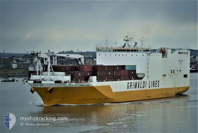
GRANDE GUINEA
Ro-Ro Cargo
Current Trip
| Time Travelled | 3 days |
|---|---|
| Remaining Time | --- |
| Distance Travelled | 958.36 nm |
| Remaining Distance | --- |
| AVG Speed | 15.6 Knots |
| MAX Speed | 21.7 Knots |
| AVG Wind | 11.5 knots |
| MAX Wind | 23 knots |
| MIN Temp | 8°C / 46.4°F |
| MAX Temp | 14.9°C / 58.82°F |
| Dybgang | 9.3 m |
| Position Modtaget | 19 h, 8 m siden |
Current Position
| Longitude | 32.30904° |
|---|---|
| Latitude | 31.43121° |
| Status | Under way using engine |
| Fart | 5.9 Knots |
| Kurs | 133.8° |
| Område | Mediterranean Sea - Eastern Basin |
| Station | T-AIS |
| Position Modtaget | 19 h, 8 m siden |
Info
Information
The current position of GRANDE GUINEA is in Mediterranean Sea - Eastern Basin with coordinates 31.43121° / 32.30904° as reported on 2025-02-13 08:57 by AIS to our vessel tracker app. The vessel's current speed is 5.9 Knots
The vessel GRANDE GUINEA (IMO: 9437919, MMSI: 247293300) is a Ro-Ro Cargo that was built in 2010 ( 15 år gamle ). It's sailing under the flag of [IT] Italy.
In this page you can find informations about the vessels current position, last detected port calls, and current voyage information. If the vessels is not in coverage by AIS you will find the latest position.
The current position of GRANDE GUINEA is detected by our AIS receivers and we are not responsible for the reliability of the data. The last position was recorded while the vessel was in Coverage by the Ais receivers of our vessel tracking app.
The current draught of GRANDE GUINEA as reported by AIS is 9.3 meters
Weather
| Temperature | 14.4°C / 57.92°F |
|---|---|
| Wind Speed | 6 knots |
| Direction | 358° N |
| Pressure | 1022.9 hPa |
| Humidity | 53.5 % |
| Cloud Coverage | 79 % |
Featured Company
Last Port Calls
| Port | Arrival | Departure | Time In Port |
|---|---|---|---|
| 2025-02-10 09:05 | 2025-02-10 18:29 | 9 h | |
| 2025-02-06 21:02 | 2025-02-07 01:23 | 4 h | |
| 2025-01-31 20:26 | 2025-02-03 00:13 | 2 d | |
| 2025-01-30 07:19 | 2025-01-30 23:26 | 16 h | |
| 2025-01-26 07:43 | 2025-01-28 18:54 | 2 d | |
| 2025-01-15 06:22 | 2025-01-17 00:18 | 1 d | |
| 2025-01-09 09:17 | 2025-01-10 06:45 | 21 h | |
| 2025-01-06 11:42 | 2025-01-07 17:12 | 1 d | |
| 2025-01-03 10:55 | 2025-01-04 09:55 | 22 h | |
| 2024-12-28 06:26 | 2024-12-28 23:47 | 17 h |
Most Visited Ports (Last year)
| Port | Arrivals | |
|---|---|---|
| 12 | ||
| 8 | ||
| 7 | ||
| 6 | ||
| 6 | ||
| 6 |
Last Trips
| Origin | Departure | Destination | Arrival | Distance | |
|---|---|---|---|---|---|
| 2025-02-07 01:23 | 2025-02-10 10:05 | 1357.36 nm | |||
| 2025-02-03 01:13 | 2025-02-06 21:02 | 1173.88 nm | |||
| 2025-01-31 00:26 | 2025-01-31 21:26 | 329.27 nm | |||
| 2025-01-28 18:54 | 2025-01-30 08:19 | 478.52 nm | |||
| 2025-01-16 19:18 | 2025-01-26 07:43 | 4025.02 nm | |||
| 2025-01-10 00:45 | 2025-01-15 01:22 | 1943.33 nm | |||
| 2025-01-07 11:12 | 2025-01-09 03:17 | 321.62 nm | |||
| 2025-01-04 03:55 | 2025-01-06 05:42 | 627.07 nm | |||
| 2024-12-28 18:47 | 2025-01-03 04:55 | 1858.91 nm | |||
| 2024-12-28 01:06 | 2024-12-28 01:26 | 0.65 nm |
Events
| Tid | Hændelsen | Detaljer | Position / Dest | Info |
|---|---|---|---|---|
| 2025-02-13 09:42 | STOP Sejllads | 9.48 nm, North of PORT SAID |
31.40914 / 32.32827
ITGIT > EGPSD
|
Fart: Kurs: 306° |
| 2025-02-13 09:01 | Status er ændret | Default Under way using engine |
31.42570 / 32.31520
ITGIT > EGPSD
|
Fart: 5.9 kn Kurs: 133.8° |
| 2025-02-13 08:57 | Udenfor Dækning |
31.43121 / 32.30904
Mediterranean Sea - Eastern Basin
ITGIT > EGPSD
|
Fart: 5.9 kn Kurs: 133.8° |
|
| 2025-02-13 08:43 | Ændre havområde | Egyptian part of the Mediterranean Sea - Eastern Basin Greek part of the Mediterranean Sea - Eastern Basin |
31.45451 / 32.28431
Mediterranean Sea - Eastern Basin
ITGIT > EGPSD
|
Fart: 11.1 kn Kurs: 140.8° |
| 2025-02-13 08:42 | Status er ændret | Under way using engine Default |
31.45689 / 32.28200
ITGIT > EGPSD
|
Fart: 14.3 kn Kurs: 140° |
| 2025-02-13 08:30 | Indenfor Dækning |
31.45451 / 32.28431
Mediterranean Sea - Eastern Basin
ITGIT > EGPSD
|
Fart: 11.1 kn Kurs: 140.8° |
|
| 2025-02-12 08:02 | Status er ændret | Default Under way using engine |
34.05426 / 25.70808
ITGIT > EGPSD
|
Fart: 16 kn Kurs: 108.2° |
| 2025-02-12 07:50 | Udenfor Dækning |
34.07334 / 25.64357
Mediterranean Sea - Eastern Basin
ITGIT > EGPSD
|
Fart: 16 kn Kurs: 108.2° |
|
| 2025-02-12 07:29 | Indenfor Dækning |
34.10100 / 25.54519
Mediterranean Sea - Eastern Basin
ITGIT > EGPSD
|
Fart: 16.4 kn Kurs: 109.1° |
|
| 2025-02-12 06:15 | Udenfor Dækning |
34.22062 / 25.17089
Mediterranean Sea - Eastern Basin
ITGIT > EGPSD
|
Fart: 15.4 kn Kurs: 111.3° |