

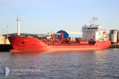
KEY BAY
Oil/Chemical Tanker

Current Trip
| Time Travelled | 2 days |
|---|---|
| Remaining Time | --- |
| Distance Travelled | 29.70 nm |
| Remaining Distance | --- |
| AVG Speed | 8.2 Knots |
| MAX Speed | 13.2 Knots |
| AVG Wind | 12.5 knots |
| MAX Wind | 22 knots |
| MIN Temp | 10.8°C / 51.44°F |
| MAX Temp | 14.6°C / 58.28°F |
| Dybgang | 4.7 m |
| Position Modtaget | 3 m siden |
Current Position
| Longitude | 10.63725° |
|---|---|
| Latitude | 56.73385° |
| Status | At anchor |
| Fart | 0.1 Knots |
| Kurs | 273° |
| Område | Kattegat |
| Station | T-AIS |
| Position Modtaget | 3 m siden |
Information
The current position of KEY BAY is in Kattegat with coordinates 56.73385° / 10.63725° as reported on 2025-05-31 13:55 by AIS to our vessel tracker app. The vessel's current speed is 0.1 Knots and is heading at the port of TERNEUZEN. The estimated time of arrival as calculated by MyShipTracking vessel tracking app is 2025-05-29 12:00 LT
The vessel KEY BAY (IMO: 9291561, MMSI: 236446000) is a Oil/Chemical Tanker that was built in 2004 ( 21 år gamle ). It's sailing under the flag of [GI] Gibraltar.
In this page you can find informations about the vessels current position, last detected port calls, and current voyage information. If the vessels is not in coverage by AIS you will find the latest position.
The current position of KEY BAY is detected by our AIS receivers and we are not responsible for the reliability of the data. The last position was recorded while the vessel was in Coverage by the Ais receivers of our vessel tracking app.
The current draught of KEY BAY as reported by AIS is 4.7 meters
Weather
| Temperature | 14.5°C / 58.1°F |
|---|---|
| Wind Speed | 9 knots |
| Direction | 287° WNW |
| Pressure | 1016.2 hPa |
| Humidity | 63.7 % |
| Cloud Coverage | --- |


Featured Company
Last Port Calls
| Port | Arrival | Departure | Time In Port |
|---|---|---|---|
| 2025-05-28 16:51 | 2025-05-29 08:44 | 15 h | |
| 2025-05-26 08:47 | 2025-05-27 18:11 | 1 d | |
| 2025-05-23 19:35 | 2025-05-24 19:49 | 1 d | |
| 2025-05-20 11:26 | 2025-05-21 07:15 | 19 h | |
| 2025-05-15 13:23 | 2025-05-16 13:49 | 1 d | |
| 2025-04-28 03:21 | 2025-05-14 15:00 | 16 d | |
| 2025-04-25 17:29 | 2025-04-28 03:20 | 2 d | |
| 2025-04-18 00:52 | 2025-04-18 13:19 | 12 h | |
| 2025-04-17 07:58 | 2025-04-17 14:16 | 6 h | |
| 2025-04-14 00:09 | 2025-04-14 07:58 | 7 h |
Most Visited Ports (Last year)
| Port | Arrivals | |
|---|---|---|
| 5 | ||
| 5 | ||
| 4 | ||
| 3 | ||
| 3 | ||
| 3 |
Last Trips
| Origin | Departure | Destination | Arrival | Distance | |
|---|---|---|---|---|---|
| 2025-05-27 18:11 | 2025-05-28 16:51 | 200.51 nm | |||
| 2025-05-24 19:49 | 2025-05-26 08:47 | 237.21 nm | |||
| 2025-05-21 07:15 | 2025-05-23 19:35 | 728.88 nm | |||
| 2025-05-16 13:49 | 2025-05-20 11:26 | 1059.14 nm | |||
| 2025-05-14 15:00 | 2025-05-15 13:23 | 171.63 nm | |||
| 2025-04-28 03:20 | 2025-04-28 03:21 | 2.36 nm | |||
| 2025-04-18 13:19 | 2025-04-25 17:29 | 1588.84 nm | |||
| 2025-04-17 14:16 | 2025-04-18 00:52 | 124.47 nm | |||
| 2025-04-14 07:58 | 2025-04-17 07:58 | 677.01 nm | |||
| 2025-04-10 10:29 | 2025-04-14 00:09 | 722.22 nm |
Events
| Tid | Hændelsen | Detaljer | Position / Dest | Info |
|---|---|---|---|---|
| 2025-05-29 10:28 | Status er ændret | At anchor Under way using engine |
56.73391 / 10.63565
FOR ORDER
|
Fart: 0.4 kn Kurs: 261° |
| 2025-05-29 10:25 | STOP Sejllads | 18.83 nm, South East of HALS |
56.73400 / 10.63621
FOR ORDER
|
Fart: 0.3 kn Kurs: 264° |
| 2025-05-29 06:44 | Afsejlet fra sidste havn |
|
56.46324 / 10.06943
FOR ORDER
|
Fart: 5.9 kn Kurs: 78° |
| 2025-05-29 06:40 | START Sejllads |
56.46203 / 10.05583
[DK] RANDERS
|
Fart: 5.1 kn Kurs: 79° |
|
| 2025-05-29 06:28 | Dybgangen er ændret | 4.7 5.7 |
56.46105 / 10.05317
[DK] RANDERS
|
Fart: 0.8 kn Kurs: 227° |
| 2025-05-29 06:28 | Destination er ændret | FOR ORDER DKRAN |
56.46105 / 10.05317
[DK] RANDERS
|
Fart: 0.8 kn Kurs: 227° |
| 2025-05-29 06:28 | ETA er ændret | 2025/05/29 10:00 2025/05/28 12:00 |
56.46105 / 10.05317
[DK] RANDERS
|
Fart: 0.8 kn Kurs: 227° |
| 2025-05-29 06:25 | STOP Sejllads |
56.46090 / 10.05321
[DK] RANDERS
|
Fart: 0.3 kn Kurs: 236° |
|
| 2025-05-29 06:24 | Indenfor Dækning |
56.46086 / 10.05330
Kattegat
[DK] RANDERS
|
Fart: 0.4 kn Kurs: 300° |
|
| 2025-05-28 15:24 | Udenfor Dækning |
56.46066 / 10.05274
Kattegat
[DK] RANDERS
|
Fart: Kurs: 339° |