
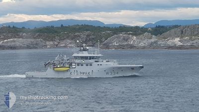
KV TOR
Patrol Vessel
Current Trip
COASTGUARD PATROL
| Time Travelled | 4 h, 52 mins |
|---|---|
| Remaining Time | --- |
| Distance Travelled | 59.75 nm |
| Remaining Distance | --- |
| AVG Speed | 12.6 Knots |
| MAX Speed | 14.2 Knots |
| AVG Wind | 6.8 knots |
| MAX Wind | 8 knots |
| MIN Temp | -4.4°C / 24.08°F |
| MAX Temp | -1.4°C / 29.48°F |
| Dybgang | 4 m |
| Position Modtaget | 1 m siden |
Current Position
| Longitude | 5.20170° |
|---|---|
| Latitude | 60.31827° |
| Status | Under way using engine |
| Fart | 9.5 Knots |
| Kurs | 11.4° |
| Område | North Sea |
| Station | T-AIS |
| Position Modtaget | 1 m siden |
Info
Information
The current position of KV TOR is in North Sea with coordinates 60.31827° / 5.20170° as reported on 2026-01-10 18:13 by AIS to our vessel tracker app. The vessel's current speed is 9.5 Knots
The vessel KV TOR (IMO: 9353369, MMSI: 257083200) is a Patrol Vessel that was built in 2007 ( 19 år gamle ). It's sailing under the flag of [NO] Norway.
In this page you can find informations about the vessels current position, last detected port calls, and current voyage information. If the vessels is not in coverage by AIS you will find the latest position.
The current position of KV TOR is detected by our AIS receivers and we are not responsible for the reliability of the data. The last position was recorded while the vessel was in Coverage by the Ais receivers of our vessel tracking app.
The current draught of KV TOR as reported by AIS is 4 meters
Weather
| Temperature | -3.2°C / 26.24°F |
|---|---|
| Wind Speed | 8 knots |
| Direction | 135° SE |
| Pressure | 1023.4 hPa |
| Humidity | 57.6 % |
| Cloud Coverage | 100 % |
Featured Company
Last Port Calls
| Port | Arrival | Departure | Time In Port |
|---|---|---|---|
| 2026-01-10 14:18 | 2026-01-10 14:23 | 5 m | |
| 2026-01-08 20:09 | 2026-01-09 12:52 | 16 h | |
| 2026-01-07 21:22 | 2026-01-08 17:20 | 19 h | |
| 2025-12-31 20:33 | 2026-01-01 11:55 | 15 h | |
| 2025-12-31 15:13 | 2025-12-31 18:17 | 3 h | |
| 2025-12-30 19:41 | 2025-12-31 08:42 | 13 h | |
| 2025-12-30 15:17 | 2025-12-30 17:25 | 2 h | |
| 2025-12-28 19:12 | 2025-12-29 11:20 | 16 h | |
| 2025-12-27 17:19 | 2025-12-28 11:17 | 17 h | |
| 2025-12-27 13:36 | 2025-12-27 16:29 | 2 h |
Last Trips
| Origin | Departure | Destination | Arrival | Distance | |
|---|---|---|---|---|---|
| 2026-01-09 12:52 | 2026-01-10 14:18 | 46.22 nm | |||
| 2026-01-08 17:20 | 2026-01-08 20:09 | 30.61 nm | |||
| 2026-01-01 11:55 | 2026-01-07 21:22 | 177.55 nm | |||
| 2025-12-31 18:17 | 2025-12-31 20:33 | 1.40 nm | |||
| 2025-12-31 08:42 | 2025-12-31 15:13 | 73.97 nm | |||
| 2025-12-30 17:25 | 2025-12-30 19:41 | 26.05 nm | |||
| 2025-12-29 11:20 | 2025-12-30 15:17 | 81.25 nm | |||
| 2025-12-28 11:17 | 2025-12-28 19:12 | 47.45 nm | |||
| 2025-12-27 16:29 | 2025-12-27 17:19 | 5.55 nm | |||
| 2025-12-26 12:40 | 2025-12-27 13:36 | 152.30 nm |
Events
| Tid | Hændelsen | Detaljer | Position / Dest | Info |
|---|---|---|---|---|
| 2026-01-10 13:23 | Afsejlet fra sidste havn |
|
59.40019 / 5.27291
COASTGUARD PATROL
|
Fart: 6.9 kn Kurs: 248° |
| 2026-01-10 13:21 | START Sejllads |
59.40301 / 5.27687
[NO] HAUGESUND
|
Fart: 5 kn Kurs: 170° |
|
| 2026-01-10 13:18 | STOP Sejllads |
59.40511 / 5.27516
[NO] HAUGESUND
|
Fart: 0.2 kn Kurs: 137° |
|
| 2026-01-10 13:18 | Skibe i havn |
|
59.40511 / 5.27514
[NO] HAUGESUND
|
Fart: 0.8 kn Kurs: 121° |
| 2026-01-10 11:54 | START Sejllads | 2.14 nm, North East of AUSTRE BOKN |
59.23602 / 5.52730
COASTGUARD PATROL
|
Fart: 10.6 kn Kurs: 298.4° |
| 2026-01-10 11:40 | Status er ændret | Under way using engine At anchor |
59.23615 / 5.53094
COASTGUARD PATROL
|
Fart: 0.1 kn Kurs: 108° |
| 2026-01-10 04:22 | Status er ændret | At anchor Default |
59.23473 / 5.53142
COASTGUARD PATROL
|
Fart: Kurs: -1° |
| 2026-01-10 04:18 | Status er ændret | Default At anchor |
59.23500 / 5.53167
COASTGUARD PATROL
|
Fart: 0.1 kn Kurs: 47° |
| 2026-01-09 22:34 | Status er ændret | At anchor Default |
59.23509 / 5.53044
COASTGUARD PATROL
|
Fart: Kurs: 48° |
| 2026-01-09 22:28 | Status er ændret | Default At anchor |
59.23513 / 5.53042
COASTGUARD PATROL
|
Fart: Kurs: 48° |