
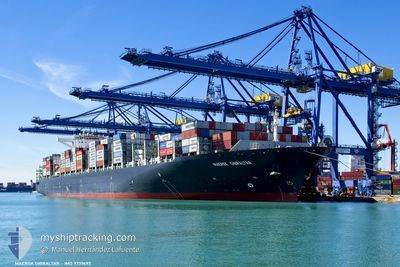
MAERSK GIBRALTAR
Cargo A
Current Trip
| Trip Time | 2 days |
|---|---|
| Trip Distance | 236.66 nm |
| AVG Speed | 7.5 Knots |
| MAX Speed | 7.5 Knots |
| Dybgang | 9.8 m |
| AVG Wind | 19.1 knots |
| MAX Wind | 25 knots |
| MIN Temp | 3°C / 37.4°F |
| MAX Temp | 7.7°C / 45.86°F |
| Position Modtaget | Nu |
Current Position
| Longitude | 1.29668° |
|---|---|
| Latitude | 51.95966° |
| Status | Moored |
| Fart | |
| Kurs | 306° |
| Område | North Sea |
| Station | T-AIS |
| Position Modtaget | Nu |
Info
Information
The current position of MAERSK GIBRALTAR is in North Sea with coordinates 51.95966° / 1.29668° as reported on 2025-02-12 03:11 by AIS to our vessel tracker app. The vessel's current speed is 0 Knots and is currently inside the port of FELIXSTOWE.
The vessel MAERSK GIBRALTAR (IMO: 9739692, MMSI: 477636200) is a Cargo A It's sailing under the flag of [HK] Hong Kong.
In this page you can find informations about the vessels current position, last detected port calls, and current voyage information. If the vessels is not in coverage by AIS you will find the latest position.
The current position of MAERSK GIBRALTAR is detected by our AIS receivers and we are not responsible for the reliability of the data. The last position was recorded while the vessel was in Coverage by the Ais receivers of our vessel tracking app.
The current draught of MAERSK GIBRALTAR as reported by AIS is 9.8 meters
Weather
| Temperature | 3.8°C / 38.84°F |
|---|---|
| Wind Speed | 7 knots |
| Direction | 326° NW |
| Pressure | 1017.5 hPa |
| Humidity | 81.7 % |
| Cloud Coverage | 100 % |
Featured Company
Last Port Calls
| Port | Arrival | Departure | Time In Port |
|---|---|---|---|
| 2025-02-10 16:34 | |||
| 2025-02-07 04:27 | 2025-02-07 23:02 | 18 h | |
| 2025-01-30 05:27 | 2025-01-30 18:55 | 13 h | |
| 2025-01-02 19:41 | 2025-01-03 18:53 | 23 h | |
| 2024-12-31 06:05 | 2025-01-01 06:48 | 1 d | |
| 2024-12-26 09:58 | 2024-12-27 17:47 | 1 d | |
| 2024-12-22 03:16 | 2024-12-23 05:44 | 1 d |
Most Visited Ports (Last year)
| Port | Arrivals | |
|---|---|---|
| 6 | ||
| 5 | ||
| 5 | ||
| 5 | ||
| 5 | ||
| 4 |
Last Trips
| Origin | Departure | Destination | Arrival | Distance | |
|---|---|---|---|---|---|
| 2025-02-08 00:02 | 2025-02-10 16:34 | 236.66 nm | |||
| 2025-01-30 19:55 | 2025-02-07 05:27 | 1541.25 nm | |||
| 2025-01-04 00:23 | 2025-01-30 06:27 | 9881.84 nm | |||
| 2025-01-01 12:18 | 2025-01-03 01:11 | 430.76 nm | |||
| 2024-12-27 21:47 | 2024-12-31 11:35 | 1067.29 nm | |||
| 2024-12-23 09:44 | 2024-12-26 13:58 | 935.96 nm | |||
| 2024-11-26 00:47 | 2024-12-22 07:16 | 9165.55 nm |
Events
| Tid | Hændelsen | Detaljer | Position / Dest | Info |
|---|---|---|---|---|
| 2025-02-10 17:51 | Status er ændret | Moored Under way using engine |
51.95969 / 1.29660
[GB] FELIXSTOWE
|
Fart: Kurs: 306° |
| 2025-02-10 16:39 | STOP Sejllads |
51.95916 / 1.29651
[GB] FELIXSTOWE
|
Fart: 0.3 kn Kurs: 311° |
|
| 2025-02-10 16:34 | Skibe i havn |
|
51.95786 / 1.29759
[GB] FELIXSTOWE
|
Fart: 2.3 kn Kurs: 319° |
| 2025-02-10 03:34 | START Sejllads |
52.00528 / 2.19319
GBFXT
|
Fart: 3.2 kn Kurs: 337° |
|
| 2025-02-10 01:04 | STOP Sejllads |
52.00839 / 2.27724
GBFXT
|
Fart: 0.3 kn Kurs: 322° |
|
| 2025-02-09 20:42 | ETA er ændret | 2025/02/10 08:00 2025/02/09 17:30 |
52.00527 / 2.39163
GBFXT
|
Fart: 9.4 kn Kurs: 34.2° |
| 2025-02-09 16:47 | START Sejllads | 15.27 nm, East of FELIXSTOWE |
51.91730 / 1.70518
GBFXT
|
Fart: 3.1 kn Kurs: 60° |
| 2025-02-09 16:45 | Status er ændret | Under way using engine At anchor |
51.91578 / 1.70498
GBFXT
|
Fart: 0.6 kn Kurs: 12° |
| 2025-02-09 15:40 | ETA er ændret | 2025/02/09 17:30 2025/02/11 07:00 |
51.91628 / 1.70485
GBFXT
|
Fart: Kurs: 39° |
| 2025-02-08 21:10 | Status er ændret | At anchor Default |
51.91847 / 1.70483
GBFXT
|
Fart: Kurs: 97° |