
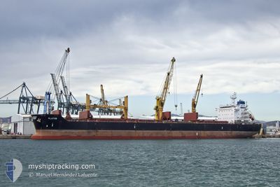
PLATON
Bulk Carrier
Current Trip
MALTA
| Time Travelled | 8 days |
|---|---|
| Remaining Time | --- |
| Distance Travelled | 2003.93 nm |
| Remaining Distance | --- |
| AVG Speed | 11 Knots |
| MAX Speed | 13.2 Knots |
| AVG Wind | 15.3 knots |
| MAX Wind | 30.7 knots |
| MIN Temp | 5.7°C / 42.26°F |
| MAX Temp | 18.8°C / 65.84°F |
| Dybgang | 12.8 m |
| Position Modtaget | 1 d siden |
Current Position
| Longitude | -5.78308° |
|---|---|
| Latitude | 35.93637° |
| Status | Under way using engine |
| Fart | 8 Knots |
| Kurs | 249° |
| Område | Strait of Gibraltar |
| Station | T-AIS |
| Position Modtaget | 1 d siden |
Info
Information
The current position of PLATON is in Strait of Gibraltar with coordinates 35.93637° / -5.78308° as reported on 2026-01-06 07:15 by AIS to our vessel tracker app. The vessel's current speed is 8 Knots
The vessel PLATON (IMO: 9452555, MMSI: 538004270) is a Bulk Carrier that was built in 2011 ( 15 år gamle ). It's sailing under the flag of [MH] Marshall Is.
In this page you can find informations about the vessels current position, last detected port calls, and current voyage information. If the vessels is not in coverage by AIS you will find the latest position.
The current position of PLATON is detected by our AIS receivers and we are not responsible for the reliability of the data. The last position was recorded while the vessel was in Coverage by the Ais receivers of our vessel tracking app.
The current draught of PLATON as reported by AIS is 12.8 meters
Weather
| Temperature | 16°C / 60.8°F |
|---|---|
| Wind Speed | 19 knots |
| Direction | 35° NE |
| Pressure | 1029.5 hPa |
| Humidity | 57.9 % |
| Cloud Coverage | 100 % |
Featured Company
Last Port Calls
| Port | Arrival | Departure | Time In Port |
|---|---|---|---|
| 2025-12-22 13:17 | 2025-12-30 15:52 | 8 d | |
| 2025-12-18 07:30 | 2025-12-18 16:34 | 9 h | |
| 2025-11-26 12:58 | 2025-11-28 04:02 | 1 d | |
| 2025-11-26 12:26 | 2025-11-26 12:38 | 12 m | |
| 2025-11-06 00:47 |
Most Visited Ports (Last year)
| Port | Arrivals | |
|---|---|---|
| 3 | ||
| 2 | ||
| 2 | ||
| 2 | ||
| 2 | ||
| 1 |
Last Trips
| Origin | Departure | Destination | Arrival | Distance | |
|---|---|---|---|---|---|
| 2025-12-18 16:34 | 2025-12-22 13:17 | 36.12 nm | |||
| 2025-11-28 04:02 | 2025-12-18 07:30 | 5146.48 nm | |||
| 2025-11-26 12:38 | 2025-11-26 12:58 | 0.63 nm | |||
| 2025-11-06 00:47 | 2025-11-26 12:26 | 5264.84 nm |
Events
| Tid | Hændelsen | Detaljer | Position / Dest | Info |
|---|---|---|---|---|
| 2026-01-06 07:21 | Status er ændret | Default Under way using engine |
35.93196 / -5.79785
MALTA
|
Fart: 8 kn Kurs: 249° |
| 2026-01-06 07:15 | Udenfor Dækning |
35.93637 / -5.78308
Strait of Gibraltar
|
Fart: 8 kn Kurs: 249° |
|
| 2026-01-06 07:10 | Ændre havområde | Moroccan part of the Strait of Gibraltar Spanish part of the Strait of Gibraltar |
35.94052 / -5.76907
Strait of Gibraltar
|
Fart: 7.6 kn Kurs: 252° |
| 2026-01-06 07:02 | Status er ændret | Under way using engine Default |
35.94615 / -5.74937
MALTA
|
Fart: 8.6 kn Kurs: 250° |
| 2026-01-06 06:54 | Status er ændret | Default Under way using engine |
35.95438 / -5.72353
MALTA
|
Fart: 8.7 kn Kurs: 267° |
| 2026-01-06 06:47 | Ændre havområde | Spanish part of the Strait of Gibraltar Maltese part of the Mediterranean Sea - Eastern Basin |
35.95710 / -5.70838
Strait of Gibraltar
|
Fart: 8.7 kn Kurs: 267° |
| 2026-01-06 06:47 | Status er ændret | Under way using engine Default |
35.95710 / -5.70838
MALTA
|
Fart: 8.7 kn Kurs: 267° |
| 2026-01-06 06:29 | Indenfor Dækning |
35.95710 / -5.70838
Strait of Gibraltar
|
Fart: 8.7 kn Kurs: 267° |
|
| 2025-12-30 13:52 | Afsejlet fra sidste havn |
|
31.16145 / 29.82970
MALTA
|
Fart: 10.6 kn Kurs: 216° |
| 2025-12-30 13:32 | START Sejllads |
31.19180 / 29.87198
[EG] ALEXANDRIA
|
Fart: 6.7 kn Kurs: 246° |