
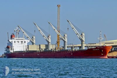
SEA BRAVE
Bulk Carrier
Current Trip
| Time Travelled | 1 day |
|---|---|
| Remaining Time | --- |
| Distance Travelled | 253.61 nm |
| Remaining Distance | --- |
| AVG Speed | 10.6 Knots |
| MAX Speed | 14.7 Knots |
| AVG Wind | 21.6 knots |
| MAX Wind | 32 knots |
| MIN Temp | 13.5°C / 56.3°F |
| MAX Temp | 17°C / 62.6°F |
| Dybgang | 7.9 m |
| Position Modtaget | 8 m siden |
Current Position
| Longitude | -4.37328° |
|---|---|
| Latitude | 36.07103° |
| Status | Under way using engine |
| Fart | 11 Knots |
| Kurs | 80.3° |
| Område | Alboran Sea |
| Station | T-AIS |
| Position Modtaget | 8 m siden |
Info
Information
The current position of SEA BRAVE is in Alboran Sea with coordinates 36.07103° / -4.37328° as reported on 2025-03-12 15:52 by AIS to our vessel tracker app. The vessel's current speed is 11 Knots and is heading at the port of BIZERTE. The estimated time of arrival as calculated by MyShipTracking vessel tracking app is 2025-03-14 05:00 LT
The vessel SEA BRAVE (IMO: 9279551, MMSI: 538003930) is a Bulk Carrier that was built in 2004 ( 21 år gamle ). It's sailing under the flag of [MH] Marshall Is.
In this page you can find informations about the vessels current position, last detected port calls, and current voyage information. If the vessels is not in coverage by AIS you will find the latest position.
The current position of SEA BRAVE is detected by our AIS receivers and we are not responsible for the reliability of the data. The last position was recorded while the vessel was in Coverage by the Ais receivers of our vessel tracking app.
The current draught of SEA BRAVE as reported by AIS is 7.9 meters
Weather
| Temperature | 15.4°C / 59.72°F |
|---|---|
| Wind Speed | 19 knots |
| Direction | 287° WNW |
| Pressure | 1007.4 hPa |
| Humidity | 79.1 % |
| Cloud Coverage | 100 % |
Featured Company
Last Port Calls
| Port | Arrival | Departure | Time In Port |
|---|---|---|---|
| 2025-02-23 12:31 | 2025-03-11 06:41 | 15 d | |
| 2025-02-02 23:04 | 2025-02-07 03:38 | 4 d | |
| 2025-01-28 01:33 | 2025-01-28 09:05 | 7 h | |
| 2025-01-17 07:13 |
Most Visited Ports (Last year)
| Port | Arrivals | |
|---|---|---|
| 2 | ||
| 2 | ||
| 1 | ||
| 1 | ||
| 1 | ||
| 1 |
Last Trips
| Origin | Departure | Destination | Arrival | Distance | |
|---|---|---|---|---|---|
| 2025-02-07 04:38 | 2025-02-23 12:31 | 261.01 nm | |||
| 2025-01-28 09:05 | 2025-02-03 00:04 | 559.51 nm | |||
| 2025-01-17 08:13 | 2025-01-28 01:33 | 2716.95 nm |
Events
| Tid | Hændelsen | Detaljer | Position / Dest | Info |
|---|---|---|---|---|
| 2025-03-12 15:52 | Status er ændret | Under way using engine Default |
36.07103 / -4.37328
BIZERTE
|
Fart: 11.2 kn Kurs: 79° |
| 2025-03-12 15:44 | Status er ændret | Default Under way using engine |
36.06673 / -4.40348
BIZERTE
|
Fart: 11.2 kn Kurs: 81.6° |
| 2025-03-12 15:34 | Status er ændret | Under way using engine Default |
36.06132 / -4.44343
BIZERTE
|
Fart: 11.1 kn Kurs: 80° |
| 2025-03-12 15:29 | Status er ændret | Default Under way using engine |
36.05840 / -4.46084
BIZERTE
|
Fart: 11.1 kn Kurs: 82.4° |
| 2025-03-12 15:25 | Status er ændret | Under way using engine Default |
36.05688 / -4.47677
BIZERTE
|
Fart: 11.1 kn Kurs: 81° |
| 2025-03-12 15:24 | Status er ændret | Default Under way using engine |
36.05647 / -4.48056
BIZERTE
|
Fart: 11.2 kn Kurs: 75.9° |
| 2025-03-12 15:11 | Status er ændret | Under way using engine Default |
36.04943 / -4.52710
BIZERTE
|
Fart: 11.3 kn Kurs: 79° |
| 2025-03-12 15:08 | Status er ændret | Default Under way using engine |
36.04653 / -4.54076
BIZERTE
|
Fart: 11.3 kn Kurs: 79.8° |
| 2025-03-12 15:07 | Status er ændret | Under way using engine Default |
36.04624 / -4.54267
BIZERTE
|
Fart: 11.3 kn Kurs: 75° |
| 2025-03-12 15:04 | Status er ændret | Default Under way using engine |
36.04380 / -4.55660
BIZERTE
|
Fart: 11.2 kn Kurs: 84.3° |