
SINLAU BULKER
Cargo
Current Trip
| Time Travelled | 13 days |
|---|---|
| Remaining Time | --- |
| Distance Travelled | 4027.35 nm |
| Remaining Distance | --- |
| AVG Speed | 12.6 Knots |
| MAX Speed | 14.7 Knots |
| AVG Wind | 9.7 knots |
| MAX Wind | 16.5 knots |
| MIN Temp | 5.9°C / 42.62°F |
| MAX Temp | 29.6°C / 85.28°F |
| Dybgang | 6.4 m |
| Position Modtaget | 2 m siden |
Current Position
| Longitude | 151.53347° |
|---|---|
| Latitude | -23.72861° |
| Status | Under way using engine |
| Fart | 7.9 Knots |
| Kurs | 176.3° |
| Område | Coral Sea |
| Station | T-AIS |
| Position Modtaget | 2 m siden |
Info
Information
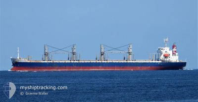
The current position of SINLAU BULKER is in Coral Sea with coordinates -23.72861° / 151.53347° as reported on 2026-01-03 19:08 by AIS to our vessel tracker app. The vessel's current speed is 7.9 Knots
The vessel SINLAU BULKER (IMO: 9749960, MMSI: 355398000) is a Cargo It's sailing under the flag of [PA] Panama.
In this page you can find informations about the vessels current position, last detected port calls, and current voyage information. If the vessels is not in coverage by AIS you will find the latest position.
The current position of SINLAU BULKER is detected by our AIS receivers and we are not responsible for the reliability of the data. The last position was recorded while the vessel was in Coverage by the Ais receivers of our vessel tracking app.
The current draught of SINLAU BULKER as reported by AIS is 6.4 meters
Weather
| Temperature | 25.7°C / 78.26°F |
|---|---|
| Wind Speed | 11 knots |
| Direction | 83° E |
| Pressure | 1012.2 hPa |
| Humidity | 64.7 % |
| Cloud Coverage | 100 % |
Featured Company
Most Visited Ports (Last year)
| Port | Arrivals | |
|---|---|---|
| 2 | ||
| 2 | ||
| 2 | ||
| 2 | ||
| 1 | ||
| 1 |
Last Trips
| Origin | Departure | Destination | Arrival | Distance | |
|---|---|---|---|---|---|
| 2025-12-18 19:38 | 2025-12-20 17:01 | 512.91 nm | |||
| 2025-11-21 11:32 | 2025-12-14 11:25 | 5699.24 nm | |||
| 2025-11-17 21:11 | 2025-11-18 16:15 | 98.29 nm | |||
| 2025-11-11 17:40 | 2025-11-16 02:02 | 231.17 nm | |||
| 2025-10-01 17:27 | 2025-11-08 10:28 | 7293.62 nm |
Events
| Tid | Hændelsen | Detaljer | Position / Dest | Info |
|---|---|---|---|---|
| 2026-01-03 18:42 | Dybgangen er ændret | 6.4 10.5 |
-23.67012 / 151.53006
AU GLT
|
Fart: 8 kn Kurs: 177.6° |
| 2026-01-03 18:42 | Destination er ændret | AU GLT CN LSN |
-23.67012 / 151.53006
AU GLT
|
Fart: 8 kn Kurs: 177.6° |
| 2026-01-03 18:42 | ETA er ændret | 2026/01/03 20:30 2025/12/10 21:00 |
-23.67012 / 151.53006
AU GLT
|
Fart: 8 kn Kurs: 177.6° |
| 2026-01-03 18:18 | Status er ændret | Under way using engine Default |
-23.61620 / 151.52697
CN LSN
|
Fart: 8.1 kn Kurs: 178° |
| 2026-01-03 18:11 | Status er ændret | Default Under way using engine |
-23.60147 / 151.52623
CN LSN
|
Fart: 8.1 kn Kurs: 177.5° |
| 2026-01-03 18:03 | Status er ændret | Under way using engine Default |
-23.58153 / 151.52532
CN LSN
|
Fart: 8.1 kn Kurs: 177° |
| 2026-01-03 17:56 | Status er ændret | Default Under way using engine |
-23.56603 / 151.52449
CN LSN
|
Fart: 8.2 kn Kurs: 175.9° |
| 2026-01-03 17:46 | Ændre havområde | Australian part of the Coral Sea New Zealand part of the South Pacific Ocean |
-23.54407 / 151.52322
Coral Sea
|
Fart: 8.2 kn Kurs: 175.8° |
| 2026-01-03 17:44 | Status er ændret | Under way using engine Default |
-23.54027 / 151.52295
CN LSN
|
Fart: 8.2 kn Kurs: 176° |
| 2026-01-03 17:44 | Indenfor Dækning |
-23.54407 / 151.52322
Coral Sea
|
Fart: 8.2 kn Kurs: 175.8° |