
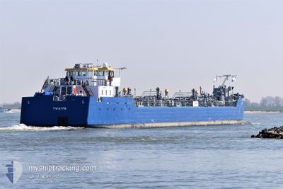
TWAITE
Tanker
Current Trip
| Time Travelled | 2 days |
|---|---|
| Remaining Time | 2 h, 38 mins |
| Distance Travelled | 93.55 nm |
| Remaining Distance | 33.40 nm |
| AVG Speed | 7.5 Knots |
| MAX Speed | 11.5 Knots |
| AVG Wind | 9.8 knots |
| MAX Wind | 17 knots |
| MIN Temp | -2.8°C / 26.96°F |
| MAX Temp | 2.3°C / 36.14°F |
| Dybgang | 2.7 m |
| Position Modtaget | 10 m siden |
Current Position
| Longitude | 4.42162° |
|---|---|
| Latitude | 51.69815° |
| Status | Under way using engine |
| Fart | |
| Kurs | --- |
| Område | North Sea |
| Station | T-AIS |
| Position Modtaget | 10 m siden |
Info
Information
The current position of TWAITE is in North Sea with coordinates 51.69815° / 4.42162° as reported on 2026-01-06 23:53 by AIS to our vessel tracker app. The vessel's current speed is 0 Knots and is heading at the port of ROTTERDAM. The estimated time of arrival as calculated by MyShipTracking vessel tracking app is 2026-01-07 03:41 LT
The vessel TWAITE (MMSI: 253242489) is a Tanker It's sailing under the flag of [LU] Luxembourg.
In this page you can find informations about the vessels current position, last detected port calls, and current voyage information. If the vessels is not in coverage by AIS you will find the latest position.
The current position of TWAITE is detected by our AIS receivers and we are not responsible for the reliability of the data. The last position was recorded while the vessel was in Coverage by the Ais receivers of our vessel tracking app.
The current draught of TWAITE as reported by AIS is 2.7 meters
Weather
| Temperature | -0.6°C / 30.92°F |
|---|---|
| Wind Speed | 13 knots |
| Direction | 193° SSW |
| Pressure | 1011.7 hPa |
| Humidity | 92.9 % |
| Cloud Coverage | 97 % |
Featured Company
Last Port Calls
| Port | Arrival | Departure | Time In Port |
|---|---|---|---|
| 2026-01-03 09:31 | 2026-01-04 11:44 | 1 d | |
| 2025-12-27 20:40 | 2025-12-27 20:56 | 16 m | |
| 2025-12-24 11:13 | 2025-12-27 20:08 | 3 d | |
| 2025-12-19 14:38 | 2025-12-20 05:30 | 14 h | |
| 2025-12-18 15:34 | 2025-12-19 08:12 | 16 h | |
| 2025-12-18 00:45 | 2025-12-18 00:49 | 3 m | |
| 2025-12-15 20:22 | 2025-12-17 13:14 | 1 d | |
| 2025-12-13 19:50 | 2025-12-13 19:54 | 4 m | |
| 2025-12-13 09:09 | 2025-12-13 09:37 | 28 m | |
| 2025-12-12 13:33 | 2025-12-13 07:23 | 17 h |
Last Trips
| Origin | Departure | Destination | Arrival | Distance | |
|---|---|---|---|---|---|
| 2025-12-27 20:56 | 2026-01-03 09:31 | 54.55 nm | |||
| 2025-12-27 20:08 | 2025-12-27 20:40 | 1.73 nm | |||
| 2025-12-20 05:30 | 2025-12-24 11:13 | 54.97 nm | |||
| 2025-12-19 08:12 | 2025-12-19 14:38 | 48.08 nm | |||
| 2025-12-18 00:49 | 2025-12-18 15:34 | 27.20 nm | |||
| 2025-12-17 13:14 | 2025-12-18 00:45 | 69.53 nm | |||
| 2025-12-13 19:54 | 2025-12-15 20:22 | 75.61 nm | |||
| 2025-12-13 09:37 | 2025-12-13 19:50 | 72.95 nm | |||
| 2025-12-13 07:23 | 2025-12-13 09:09 | 18.32 nm | |||
| 2025-12-12 12:12 | 2025-12-12 13:33 | 17.37 nm |
Events
| Tid | Hændelsen | Detaljer | Position / Dest | Info |
|---|---|---|---|---|
| 2026-01-06 23:58 | Status er ændret | Default Under way using engine |
51.69815 / 4.42162
ROTTERDAM 3E PETROH
|
Fart: Kurs: 511° |
| 2026-01-06 23:35 | STOP Sejllads | 0.73 nm, West of WILLEMSTAD |
51.69811 / 4.42156
ROTTERDAM 3E PETROH
|
Fart: 0.3 kn Kurs: 511° |
| 2026-01-06 23:28 | Status er ændret | Under way using engine Default |
51.69300 / 4.41226
ROTTERDAM 3E PETROH
|
Fart: 0.6 kn Kurs: -1° |
| 2026-01-06 23:28 | START Sejllads | 1.03 nm, West of WILLEMSTAD |
51.69300 / 4.41226
ROTTERDAM 3E PETROH
|
Fart: 5.3 kn Kurs: 49.4° |
| 2026-01-06 23:20 | Status er ændret | Default Under way using engine |
51.69091 / 4.40854
ROTTERDAM 3E PETROH
|
Fart: Kurs: 511° |
| 2026-01-06 23:14 | STOP Sejllads | 1.19 nm, West of WILLEMSTAD |
51.69089 / 4.40851
ROTTERDAM 3E PETROH
|
Fart: Kurs: 511° |
| 2026-01-06 21:06 | START Sejllads | 3.25 nm, South West of BERGEN OP ZOOM |
51.44904 / 4.22979
ROTTERDAM 3E PETROH
|
Fart: 4.8 kn Kurs: 354° |
| 2026-01-06 20:51 | STOP Sejllads | 3.35 nm, South West of BERGEN OP ZOOM |
51.44707 / 4.23021
ROTTERDAM 3E PETROH
|
Fart: 0.2 kn Kurs: 511° |
| 2026-01-06 20:26 | Status er ændret | Under way using engine Default |
51.40994 / 4.23814
ROTTERDAM 3E PETROH
|
Fart: 8.6 kn Kurs: 353° |
| 2026-01-06 20:13 | Status er ændret | Default Under way using engine |
51.38007 / 4.25623
ROTTERDAM 3E PETROH
|
Fart: 8.4 kn Kurs: 277.3° |