
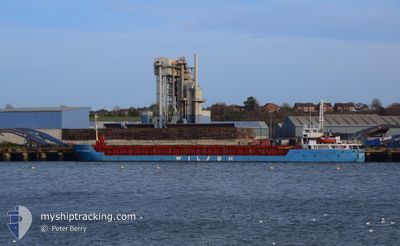
WILSON DORDRECHT
General Cargo
Current Trip
| Time Travelled | 3 days |
|---|---|
| Remaining Time | --- |
| Distance Travelled | 594.22 nm |
| Remaining Distance | --- |
| AVG Speed | 8.4 Knots |
| MAX Speed | 10 Knots |
| AVG Wind | 16.4 knots |
| MAX Wind | 25.1 knots |
| MIN Temp | 3.6°C / 38.48°F |
| MAX Temp | 6.6°C / 43.88°F |
| Dybgang | 4.7 m |
| Position Modtaget | 5 h, 12 m siden |
Current Position
| Longitude | -4.25570° |
|---|---|
| Latitude | 58.70082° |
| Status | Under way using engine |
| Fart | 8.1 Knots |
| Kurs | 265.9° |
| Område | North Atlantic Ocean |
| Station | T-AIS |
| Position Modtaget | 5 h, 12 m siden |
Info
Information
The current position of WILSON DORDRECHT is in North Atlantic Ocean with coordinates 58.70082° / -4.25570° as reported on 2025-02-11 09:35 by AIS to our vessel tracker app. The vessel's current speed is 8.1 Knots and is heading at the port of KYLEAKIN. The estimated time of arrival as calculated by MyShipTracking vessel tracking app is 2025-02-12 02:00 LT
The vessel WILSON DORDRECHT (IMO: 9145140, MMSI: 314474000) is a General Cargo that was built in 1996 ( 29 år gamle ). It's sailing under the flag of [BB] Barbados.
In this page you can find informations about the vessels current position, last detected port calls, and current voyage information. If the vessels is not in coverage by AIS you will find the latest position.
The current position of WILSON DORDRECHT is detected by our AIS receivers and we are not responsible for the reliability of the data. The last position was recorded while the vessel was in Coverage by the Ais receivers of our vessel tracking app.
The current draught of WILSON DORDRECHT as reported by AIS is 4.7 meters
Weather
| Temperature | 6.4°C / 43.52°F |
|---|---|
| Wind Speed | 17 knots |
| Direction | 106° ESE |
| Pressure | 1028.7 hPa |
| Humidity | 76.2 % |
| Cloud Coverage | 100 % |
Featured Company
Last Port Calls
| Port | Arrival | Departure | Time In Port |
|---|---|---|---|
| 2025-02-08 11:48 | 2025-02-08 14:48 | 3 h | |
| 2025-02-06 13:55 | 2025-02-06 18:18 | 4 h | |
| 2025-02-06 08:29 | 2025-02-06 12:43 | 4 h | |
| 2025-02-06 03:08 | 2025-02-06 07:20 | 4 h | |
| 2025-02-03 20:06 | 2025-02-05 16:21 | 1 d | |
| 2025-02-02 17:30 | 2025-02-02 21:27 | 3 h | |
| 2025-01-27 17:11 | 2025-01-28 16:42 | 23 h | |
| 2025-01-23 00:51 | 2025-01-23 01:44 | 53 m | |
| 2025-01-23 00:09 | 2025-01-23 00:28 | 18 m | |
| 2025-01-20 06:19 | 2025-01-22 23:23 | 2 d |
Last Trips
| Origin | Departure | Destination | Arrival | Distance | |
|---|---|---|---|---|---|
| 2025-02-06 18:18 | 2025-02-08 11:48 | 271.45 nm | |||
| 2025-02-06 12:43 | 2025-02-06 13:55 | 4.41 nm | |||
| 2025-02-06 07:20 | 2025-02-06 08:29 | 4.71 nm | |||
| 2025-02-05 16:21 | 2025-02-06 03:08 | 111.29 nm | |||
| 2025-02-02 21:27 | 2025-02-03 20:06 | 111.16 nm | |||
| 2025-01-28 16:42 | 2025-02-02 17:30 | 611.66 nm | |||
| 2025-01-23 01:44 | 2025-01-27 17:11 | 937.84 nm | |||
| 2025-01-23 00:28 | 2025-01-23 00:51 | 1.97 nm | |||
| 2025-01-22 23:23 | 2025-01-23 00:09 | 4.62 nm | |||
| 2025-01-20 05:32 | 2025-01-20 06:19 | 5.37 nm |
Events
| Tid | Hændelsen | Detaljer | Position / Dest | Info |
|---|---|---|---|---|
| 2025-02-11 10:05 | Status er ændret | Default Under way using engine |
58.69597 / -4.38792
GB KYN
|
Fart: 8.1 kn Kurs: 265.9° |
| 2025-02-11 09:35 | Udenfor Dækning |
58.70082 / -4.25570
North Atlantic Ocean
GB KYN
|
Fart: 8.1 kn Kurs: 265.9° |
|
| 2025-02-11 06:14 | Ændre havområde | United Kingdom part of the North Atlantic Ocean United Kingdom part of the North Sea |
58.71018 / -3.42143
North Atlantic Ocean
GB KYN
|
Fart: 8 kn Kurs: 271.1° |
| 2025-02-11 02:00 | Fundet i havområde | United Kingdom part of the North Sea |
58.50338 / -2.40932
North Sea
GB KYN
|
Fart: 8.9 kn Kurs: 315.7° |
| 2025-02-11 02:00 | Status er ændret | Under way using engine Default |
58.50338 / -2.40932
GB KYN
|
Fart: 8.9 kn Kurs: 315° |
| 2025-02-11 01:59 | Indenfor Dækning |
58.50338 / -2.40932
North Sea
GB KYN
|
Fart: 8.9 kn Kurs: 315.7° |
|
| 2025-02-09 13:27 | Status er ændret | Default Under way using engine |
55.46405 / 4.40484
GB KYN
|
Fart: 7.7 kn Kurs: 302.8° |
| 2025-02-09 13:22 | Udenfor Dækning |
55.45816 / 4.42156
North Sea
GB KYN
|
Fart: 7.7 kn Kurs: 302.8° |
|
| 2025-02-09 10:13 | Indenfor Dækning |
55.20711 / 5.04794
North Sea
GB KYN
|
Fart: 8.5 kn Kurs: 304.3° |
|
| 2025-02-08 19:16 | Udenfor Dækning |
53.87553 / 7.87017
North Sea
GB KYN
|
Fart: 8 kn Kurs: 285° |