
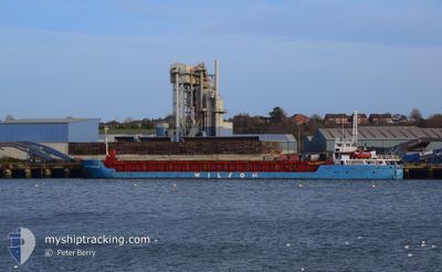
WILSON DORDRECHT
General Cargo
Current Trip
| Time Travelled | 3 days |
|---|---|
| Remaining Time | --- |
| Distance Travelled | 601.94 nm |
| Remaining Distance | --- |
| AVG Speed | 8.4 Noeuds |
| MAX Speed | 10 Noeuds |
| AVG Wind | 16.4 knots |
| MAX Wind | 25.1 knots |
| MIN Temp | 3.6°C / 38.48°F |
| MAX Temp | 6.6°C / 43.88°F |
| Tirant d eau | 4.7 m |
| Position reçue | 6 h, 6 m depuis |
Current Position
| Longitude | -4.25570° |
|---|---|
| Latitude | 58.70082° |
| Etat | Under way using engine |
| Vitesse | 8.1 Noeuds |
| Parcours | 265.9° |
| Zone | North Atlantic Ocean |
| Station | T-AIS |
| Position reçue | 6 h, 6 m depuis |
Info
Information
The current position of WILSON DORDRECHT is in North Atlantic Ocean with coordinates 58.70082° / -4.25570° as reported on 2025-02-11 09:35 by AIS to our vessel tracker app. The vessel's current speed is 8.1 Noeuds and is heading at the port of KYLEAKIN. The estimated time of arrival as calculated by MyShipTracking vessel tracking app is 2025-02-12 02:00 LT
The vessel WILSON DORDRECHT (IMO: 9145140, MMSI: 314474000) is a General Cargo that was built in 1996 ( 29 Age ). It's sailing under the flag of [BB] Barbados.
In this page you can find informations about the vessels current position, last detected port calls, and current voyage information. If the vessels is not in coverage by AIS you will find the latest position.
The current position of WILSON DORDRECHT is detected by our AIS receivers and we are not responsible for the reliability of the data. The last position was recorded while the vessel was in Coverage by the Ais receivers of our vessel tracking app.
The current draught of WILSON DORDRECHT as reported by AIS is 4.7 meters
Weather
| Temperature | 6.3°C / 43.34°F |
|---|---|
| Wind Speed | 17 knots |
| Direction | 109° ESE |
| Pressure | 1027.7 hPa |
| Humidity | 74.9 % |
| Cloud Coverage | 94 % |
Featured Company
Last Port Calls
| Port | Arrival | Departure | Time In Port |
|---|---|---|---|
| 2025-02-08 11:48 | 2025-02-08 14:48 | 3 h | |
| 2025-02-06 13:55 | 2025-02-06 18:18 | 4 h | |
| 2025-02-06 08:29 | 2025-02-06 12:43 | 4 h | |
| 2025-02-06 03:08 | 2025-02-06 07:20 | 4 h | |
| 2025-02-03 20:06 | 2025-02-05 16:21 | 1 d | |
| 2025-02-02 17:30 | 2025-02-02 21:27 | 3 h | |
| 2025-01-27 17:11 | 2025-01-28 16:42 | 23 h | |
| 2025-01-23 00:51 | 2025-01-23 01:44 | 53 m | |
| 2025-01-23 00:09 | 2025-01-23 00:28 | 18 m | |
| 2025-01-20 06:19 | 2025-01-22 23:23 | 2 d |
Last Trips
| Origin | Departure | Destination | Arrival | Distance | |
|---|---|---|---|---|---|
| 2025-02-06 18:18 | 2025-02-08 11:48 | 271.45 nm | |||
| 2025-02-06 12:43 | 2025-02-06 13:55 | 4.41 nm | |||
| 2025-02-06 07:20 | 2025-02-06 08:29 | 4.71 nm | |||
| 2025-02-05 16:21 | 2025-02-06 03:08 | 111.29 nm | |||
| 2025-02-02 21:27 | 2025-02-03 20:06 | 111.16 nm | |||
| 2025-01-28 16:42 | 2025-02-02 17:30 | 611.66 nm | |||
| 2025-01-23 01:44 | 2025-01-27 17:11 | 937.84 nm | |||
| 2025-01-23 00:28 | 2025-01-23 00:51 | 1.97 nm | |||
| 2025-01-22 23:23 | 2025-01-23 00:09 | 4.62 nm | |||
| 2025-01-20 05:32 | 2025-01-20 06:19 | 5.37 nm |
Events
| Heure | Evenement | Détails | Position/ Destination | Info |
|---|---|---|---|---|
| 2025-02-11 10:05 | Etat Changé | Default Under way using engine |
58.69597 / -4.38792
GB KYN
|
Vitesse: 8.1 kn Parcours: 265.9° |
| 2025-02-11 09:35 | Hors de la zone couverte |
58.70082 / -4.25570
North Atlantic Ocean
GB KYN
|
Vitesse: 8.1 kn Parcours: 265.9° |
|
| 2025-02-11 06:14 | Changement de zone | United Kingdom part of the North Atlantic Ocean United Kingdom part of the North Sea |
58.71018 / -3.42143
North Atlantic Ocean
GB KYN
|
Vitesse: 8 kn Parcours: 271.1° |
| 2025-02-11 02:00 | Detecté en mer | United Kingdom part of the North Sea |
58.50338 / -2.40932
North Sea
GB KYN
|
Vitesse: 8.9 kn Parcours: 315.7° |
| 2025-02-11 02:00 | Etat Changé | Under way using engine Default |
58.50338 / -2.40932
GB KYN
|
Vitesse: 8.9 kn Parcours: 315° |
| 2025-02-11 01:59 | Dans la zone couverte |
58.50338 / -2.40932
North Sea
GB KYN
|
Vitesse: 8.9 kn Parcours: 315.7° |
|
| 2025-02-09 13:27 | Etat Changé | Default Under way using engine |
55.46405 / 4.40484
GB KYN
|
Vitesse: 7.7 kn Parcours: 302.8° |
| 2025-02-09 13:22 | Hors de la zone couverte |
55.45816 / 4.42156
North Sea
GB KYN
|
Vitesse: 7.7 kn Parcours: 302.8° |
|
| 2025-02-09 10:13 | Dans la zone couverte |
55.20711 / 5.04794
North Sea
GB KYN
|
Vitesse: 8.5 kn Parcours: 304.3° |
|
| 2025-02-08 19:16 | Hors de la zone couverte |
53.87553 / 7.87017
North Sea
GB KYN
|
Vitesse: 8 kn Parcours: 285° |