
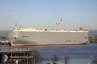
AEGEAN HIGHWAY
Vehicles Carrier
Current Trip
| Trip Time | 2 days |
|---|---|
| Trip Distance | 845.53 nm |
| AVG Speed | 10.4 Noeuds |
| MAX Speed | 10.4 Noeuds |
| Tirant d eau | 8.9 m |
| AVG Wind | 15.3 knots |
| MAX Wind | 22 knots |
| MIN Temp | 0.3°C / 32.54°F |
| MAX Temp | 10.7°C / 51.26°F |
| Position reçue | 4 m depuis |
Current Position
| Longitude | -74.13485° |
|---|---|
| Latitude | 40.69088° |
| Etat | Moored |
| Vitesse | |
| Parcours | 325° |
| Zone | North Atlantic Ocean |
| Station | T-AIS |
| Position reçue | 4 m depuis |
Info
Information
The current position of AEGEAN HIGHWAY is in North Atlantic Ocean with coordinates 40.69088° / -74.13485° as reported on 2025-02-24 02:13 by AIS to our vessel tracker app. The vessel's current speed is 0 Noeuds and is currently inside the port of NEW YORK.
The vessel AEGEAN HIGHWAY (IMO: 9464388, MMSI: 432666000) is a Vehicles Carrier that was built in 2008 ( 17 Age ). It's sailing under the flag of [JP] Japan.
In this page you can find informations about the vessels current position, last detected port calls, and current voyage information. If the vessels is not in coverage by AIS you will find the latest position.
The current position of AEGEAN HIGHWAY is detected by our AIS receivers and we are not responsible for the reliability of the data. The last position was recorded while the vessel was in Coverage by the Ais receivers of our vessel tracking app.
The current draught of AEGEAN HIGHWAY as reported by AIS is 8.9 meters
Weather
| Temperature | 2.4°C / 36.32°F |
|---|---|
| Wind Speed | 2 knots |
| Direction | 314° NW |
| Pressure | 1020.3 hPa |
| Humidity | 68.5 % |
| Cloud Coverage | 100 % |
Featured Company
Last Port Calls
| Port | Arrival | Departure | Time In Port |
|---|---|---|---|
| 2025-02-23 09:00 | |||
| 2025-02-20 11:03 | 2025-02-21 01:47 | 14 h | |
| 2025-01-23 06:33 | 2025-01-25 07:55 | 2 d | |
| 2025-01-20 21:29 | 2025-01-21 10:40 | 13 h | |
| 2024-12-31 12:45 | 2025-01-01 01:48 | 13 h | |
| 2024-12-29 06:23 | 2024-12-30 06:44 | 1 d | |
| 2024-12-12 21:17 | 2024-12-15 07:24 | 2 d |
Most Visited Ports (Last year)
| Port | Arrivals | |
|---|---|---|
| 7 | ||
| 4 | ||
| 4 | ||
| 3 | ||
| 3 | ||
| 2 |
Last Trips
| Origin | Departure | Destination | Arrival | Distance | |
|---|---|---|---|---|---|
| 2025-02-20 20:47 | 2025-02-23 04:00 | 845.53 nm | |||
| 2025-01-25 16:55 | 2025-02-20 06:03 | 9679.19 nm | |||
| 2025-01-21 19:40 | 2025-01-23 15:33 | 45.54 nm | |||
| 2024-12-31 17:48 | 2025-01-21 06:29 | 6528.80 nm | |||
| 2024-12-29 22:44 | 2024-12-31 04:45 | 429.38 nm | |||
| 2024-12-15 16:24 | 2024-12-28 22:23 | 5562.91 nm | |||
| 2024-11-28 23:14 | 2024-12-13 06:17 | 4740.72 nm |
Events
| Heure | Evenement | Détails | Position/ Destination | Info |
|---|---|---|---|---|
| 2025-02-23 11:35 | Etat Changé | Moored Under way using engine |
40.69088 / -74.13485
[US] NEW YORK
|
Vitesse: Parcours: 325° |
| 2025-02-23 11:18 | Arret |
40.69033 / -74.13483
[US] NEW YORK
|
Vitesse: 0.3 kn Parcours: 332° |
|
| 2025-02-23 09:00 | Port d'arrivée |
|
40.57930 / -74.03288
[US] NEW YORK
|
Vitesse: 9.6 kn Parcours: 349° |
| 2025-02-23 05:52 | Changement d'ETA | 2025/02/23 07:30 2025/02/23 04:00 |
40.19382 / -73.71297
US EWR
|
Vitesse: 9.6 kn Parcours: 327° |
| 2025-02-23 03:43 | Dans la zone couverte |
40.06018 / -73.62518
North Atlantic Ocean
US EWR
|
Vitesse: 8.4 kn Parcours: 334° |
|
| 2025-02-23 02:34 | Hors de la zone couverte |
40.14010 / -73.65242
North Atlantic Ocean
US EWR
|
Vitesse: 9.1 kn Parcours: 111° |
|
| 2025-02-23 02:20 | Dans la zone couverte |
40.14010 / -73.65242
North Atlantic Ocean
US EWR
|
Vitesse: 9.1 kn Parcours: 111° |
|
| 2025-02-23 01:13 | Hors de la zone couverte |
40.03643 / -73.72173
North Atlantic Ocean
US EWR
|
Vitesse: 14.5 kn Parcours: 354° |
|
| 2025-02-23 00:40 | Tirant d'eau modifié | 8.9 9.8 |
39.88828 / -73.70615
US EWR
|
Vitesse: 16.1 kn Parcours: 356° |
| 2025-02-23 00:40 | Changement de destination | US EWR LAST UPDATE TIME |
39.88828 / -73.70615
US EWR
|
Vitesse: 16.1 kn Parcours: 356° |