
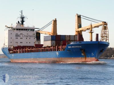
BBC MICHIGAN
General Cargo
Current Trip
| Time Travelled | 7 days |
|---|---|
| Remaining Time | 14 h, 8 mins |
| Distance Travelled | 2172.77 nm |
| Remaining Distance | 520.53 nm |
| AVG Speed | 13.7 Noeuds |
| MAX Speed | 16.4 Noeuds |
| AVG Wind | 15.3 knots |
| MAX Wind | 32 knots |
| MIN Temp | 4.1°C / 39.38°F |
| MAX Temp | 14.7°C / 58.46°F |
| Tirant d eau | 6.7 m |
| Position reçue | 11 h, 46 m depuis |
Current Position
| Longitude | 2.48568° |
|---|---|
| Latitude | 40.07320° |
| Etat | Under way using engine |
| Vitesse | 14.3 Noeuds |
| Parcours | 55.1° |
| Zone | Balearic Sea |
| Station | T-AIS |
| Position reçue | 11 h, 46 m depuis |
Info
Information
The current position of BBC MICHIGAN is in Balearic Sea with coordinates 40.07320° / 2.48568° as reported on 2025-02-05 08:20 by AIS to our vessel tracker app. The vessel's current speed is 14.3 Noeuds and is heading at the port of GENOVA. The estimated time of arrival as calculated by MyShipTracking vessel tracking app is 2025-02-06 10:14 LT
The vessel BBC MICHIGAN (IMO: 9501241, MMSI: 305460000) is a General Cargo that was built in 2010 ( 15 Age ). It's sailing under the flag of [AG] Antigua Barbuda.
In this page you can find informations about the vessels current position, last detected port calls, and current voyage information. If the vessels is not in coverage by AIS you will find the latest position.
The current position of BBC MICHIGAN is detected by our AIS receivers and we are not responsible for the reliability of the data. The last position was recorded while the vessel was in Coverage by the Ais receivers of our vessel tracking app.
The current draught of BBC MICHIGAN as reported by AIS is 6.7 meters
Weather
| Temperature | 11.7°C / 53.06°F |
|---|---|
| Wind Speed | 11 knots |
| Direction | 6° N |
| Pressure | 1031.1 hPa |
| Humidity | 80.5 % |
| Cloud Coverage | 19 % |
Featured Company
Last Port Calls
| Port | Arrival | Departure | Time In Port |
|---|---|---|---|
| 2025-01-28 13:58 | 2025-01-29 18:46 | 1 d | |
| 2025-01-27 07:37 | 2025-01-27 09:40 | 2 h | |
| 2025-01-23 09:20 | 2025-01-24 13:07 | 1 d | |
| 2025-01-17 14:17 | 2025-01-17 21:21 | 7 h | |
| 2025-01-04 13:45 | 2025-01-04 21:12 | 7 h | |
| 2024-12-28 17:47 | 2024-12-28 20:08 | 2 h | |
| 2024-12-23 15:58 | 2024-12-23 17:28 | 1 h | |
| 2024-12-20 20:44 | 2024-12-22 00:35 | 1 d | |
| 2024-12-19 18:25 | 2024-12-19 19:27 | 1 h | |
| 2024-12-16 22:58 | 2024-12-16 23:23 | 25 m |
Last Trips
| Origin | Departure | Destination | Arrival | Distance | |
|---|---|---|---|---|---|
| 2025-01-27 10:40 | 2025-01-28 14:58 | 39.23 nm | |||
| 2025-01-24 15:07 | 2025-01-27 08:37 | 815.61 nm | |||
| 2025-01-17 22:21 | 2025-01-23 11:20 | 1693.41 nm | |||
| 2025-01-04 16:12 | 2025-01-17 15:17 | 4116.69 nm | |||
| 2024-12-28 15:08 | 2025-01-04 08:45 | 1915.94 nm | |||
| 2024-12-23 12:28 | 2024-12-28 12:47 | 808.30 nm | |||
| 2024-12-21 18:35 | 2024-12-23 10:58 | 361.61 nm | |||
| 2024-12-19 14:27 | 2024-12-20 14:44 | 341.60 nm | |||
| 2024-12-16 18:23 | 2024-12-19 13:25 | 523.89 nm | |||
| 2024-12-14 23:39 | 2024-12-16 17:58 | 295.07 nm |
Events
| Heure | Evenement | Détails | Position/ Destination | Info |
|---|---|---|---|---|
| 2025-02-05 08:24 | Etat Changé | Default Under way using engine |
40.08243 / 2.50289
IT GOA
|
Vitesse: 14.3 kn Parcours: 55.1° |
| 2025-02-05 08:20 | Hors de la zone couverte |
40.07320 / 2.48568
Balearic Sea
IT GOA
|
Vitesse: 14.3 kn Parcours: 55.1° |
|
| 2025-02-05 08:10 | Detecté en mer | Spanish part of the Balearic Sea |
40.05033 / 2.44380
Balearic Sea
IT GOA
|
Vitesse: 14.1 kn Parcours: 53.8° |
| 2025-02-05 08:10 | Dans la zone couverte |
40.05033 / 2.44380
Balearic Sea
IT GOA
|
Vitesse: 14.1 kn Parcours: 53.8° |
|
| 2025-02-04 17:14 | Etat Changé | Default Under way using engine |
37.35421 / -.79449
IT GOA
|
Vitesse: 14.6 kn Parcours: 51.6° |
| 2025-02-04 16:59 | Detecté en mer | Spanish part of the Mediterranean Sea - Western Basin |
37.31294 / -.85736
Mediterranean Sea - Western Basin
IT GOA
|
Vitesse: 14.6 kn Parcours: 51.6° |
| 2025-02-04 16:59 | Hors de la zone couverte |
37.31294 / -.85736
Mediterranean Sea - Western Basin
IT GOA
|
Vitesse: 14.6 kn Parcours: 51.6° |
|
| 2025-02-04 16:58 | Etat Changé | Under way using engine Default |
37.31214 / -.85862
IT GOA
|
Vitesse: 14.5 kn Parcours: 51° |
| 2025-02-04 16:58 | Dans la zone couverte |
37.31294 / -.85736
Mediterranean Sea - Western Basin
IT GOA
|
Vitesse: 14.6 kn Parcours: 51.6° |
|
| 2025-02-04 04:41 | Hors de la zone couverte |
36.17753 / -3.83137
Alboran Sea
IT GOA
|
Vitesse: 13.3 kn Parcours: 77.9° |