

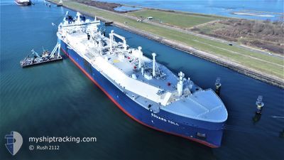
EDUARD TOLL
Tanker

Current Trip
FOR ORDERS
| Time Travelled | 14 days |
|---|---|
| Remaining Time | --- |
| Distance Travelled | 4952.16 nm |
| Remaining Distance | --- |
| AVG Speed | 17.2 Noeuds |
| MAX Speed | 21.6 Noeuds |
| AVG Wind | 12.1 knots |
| MAX Wind | 32 knots |
| MIN Temp | -14.2°C / 6.44°F |
| MAX Temp | 12.3°C / 54.14°F |
| Tirant d eau | 12 m |
| Position reçue | 10 h, 13 m depuis |
Current Position
| Longitude | 3.64510° |
|---|---|
| Latitude | 56.20436° |
| Etat | Under way using engine |
| Vitesse | 15.3 Noeuds |
| Parcours | 187.4° |
| Zone | North Sea |
| Station | T-AIS |
| Position reçue | 10 h, 13 m depuis |
Information
The current position of EDUARD TOLL is in North Sea with coordinates 56.20436° / 3.64510° as reported on 2025-04-06 13:24 by AIS to our vessel tracker app. The vessel's current speed is 15.3 Noeuds
The vessel EDUARD TOLL (IMO: 9750696, MMSI: 311000548) is a Tanker It's sailing under the flag of [BS] Bahamas.
In this page you can find informations about the vessels current position, last detected port calls, and current voyage information. If the vessels is not in coverage by AIS you will find the latest position.
The current position of EDUARD TOLL is detected by our AIS receivers and we are not responsible for the reliability of the data. The last position was recorded while the vessel was in Coverage by the Ais receivers of our vessel tracking app.
The current draught of EDUARD TOLL as reported by AIS is 12 meters
Weather
| Temperature | 6.6°C / 43.88°F |
|---|---|
| Wind Speed | 6 knots |
| Direction | 135° SE |
| Pressure | 1029.9 hPa |
| Humidity | 63.3 % |
| Cloud Coverage | 20 % |


Featured Company
Events
| Heure | Evenement | Détails | Position/ Destination | Info |
|---|---|---|---|---|
| 2025-04-06 13:24 | Etat Changé | Default Under way using engine |
56.20345 / 3.64487
FOR ORDERS
|
Vitesse: 15.3 kn Parcours: 187.4° |
| 2025-04-06 13:24 | Hors de la zone couverte |
56.20436 / 3.64510
North Sea
FOR ORDERS
|
Vitesse: 15.3 kn Parcours: 187.4° |
|
| 2025-04-06 13:17 | Etat Changé | Under way using engine Default |
56.23286 / 3.65146
FOR ORDERS
|
Vitesse: 15.3 kn Parcours: 186° |
| 2025-04-06 12:34 | Etat Changé | Default Under way using engine |
56.41523 / 3.68459
FOR ORDERS
|
Vitesse: 15.2 kn Parcours: 181° |
| 2025-04-06 12:25 | Dans la zone couverte |
56.45110 / 3.68584
North Sea
FOR ORDERS
|
Vitesse: 15.2 kn Parcours: 181° |
|
| 2025-04-06 12:25 | Etat Changé | Under way using engine Default |
56.45365 / 3.68592
FOR ORDERS
|
Vitesse: 15.3 kn Parcours: 181° |
| 2025-04-06 05:45 | Hors de la zone couverte |
58.20132 / 3.88349
North Sea
FOR ORDERS
|
Vitesse: 17.2 kn Parcours: 193.7° |
|
| 2025-04-06 04:11 | Etat Changé | Under way using engine Default |
58.63942 / 3.97265
FOR ORDERS
|
Vitesse: 16.8 kn Parcours: 183° |
| 2025-04-06 03:46 | Etat Changé | Default Under way using engine |
58.75780 / 3.98453
FOR ORDERS
|
Vitesse: 16.7 kn Parcours: 182.8° |
| 2025-04-06 03:40 | Etat Changé | Under way using engine Default |
58.78426 / 3.98703
FOR ORDERS
|
Vitesse: 16.6 kn Parcours: 183° |