

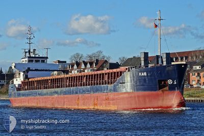
KAIE
General Cargo

Current Trip
RULED
| Time Travelled | 7 h, 46 mins |
|---|---|
| Remaining Time | --- |
| Distance Travelled | 51.46 nm |
| Remaining Distance | --- |
| AVG Speed | 9 Noeuds |
| MAX Speed | 10.4 Noeuds |
| AVG Wind | 10.6 knots |
| MAX Wind | 12.6 knots |
| MIN Temp | 8.1°C / 46.58°F |
| MAX Temp | 17.3°C / 63.14°F |
| Tirant d eau | 8.3 m |
| Position reçue | 14 m depuis |
Current Position
| Longitude | 28.47403° |
|---|---|
| Latitude | 60.02411° |
| Etat | At anchor |
| Vitesse | 0.7 Noeuds |
| Parcours | 287° |
| Zone | Gulf of Finland |
| Station | T-AIS |
| Position reçue | 14 m depuis |
Information
The current position of KAIE is in Gulf of Finland with coordinates 60.02411° / 28.47403° as reported on 2025-05-23 15:01 by AIS to our vessel tracker app. The vessel's current speed is 0.7 Noeuds
The vessel KAIE (IMO: 9504102, MMSI: 305036000) is a General Cargo that was built in 2010 ( 15 Age ). It's sailing under the flag of [AG] Antigua Barbuda.
In this page you can find informations about the vessels current position, last detected port calls, and current voyage information. If the vessels is not in coverage by AIS you will find the latest position.
The current position of KAIE is detected by our AIS receivers and we are not responsible for the reliability of the data. The last position was recorded while the vessel was in Coverage by the Ais receivers of our vessel tracking app.
The current draught of KAIE as reported by AIS is 8.3 meters
Weather
| Temperature | 8.2°C / 46.76°F |
|---|---|
| Wind Speed | 8 knots |
| Direction | 256° WSW |
| Pressure | 1012.8 hPa |
| Humidity | 88.4 % |
| Cloud Coverage | 100 % |


Featured Company
Last Port Calls
| Port | Arrival | Departure | Time In Port |
|---|---|---|---|
| 2025-05-23 10:30 | |||
| 2025-05-09 23:56 | 2025-05-11 14:37 | 1 d | |
| 2025-05-03 20:40 | 2025-05-04 21:50 | 1 d | |
| 2025-04-21 17:04 | 2025-04-22 07:28 | 14 h | |
| 2025-04-20 12:06 | |||
| 2025-04-07 22:32 | |||
| 2025-03-29 18:39 | 2025-04-01 20:31 | 3 d | |
| 2025-03-15 11:49 |
Most Visited Ports (Last year)
| Port | Arrivals | |
|---|---|---|
| 9 | ||
| 4 | ||
| 2 | ||
| 2 | ||
| 2 | ||
| 1 |
Last Trips
| Origin | Departure | Destination | Arrival | Distance | |
|---|---|---|---|---|---|
| 2025-05-04 21:50 | 2025-05-09 23:56 | 388.67 nm | |||
| 2025-04-22 07:28 | 2025-05-03 20:40 | 1445.24 nm | |||
| 2025-04-20 12:06 | 2025-04-21 17:04 | 344.76 nm | |||
| 2025-03-15 11:49 | 2025-03-29 18:39 | 1971.07 nm |
Events
| Heure | Evenement | Détails | Position/ Destination | Info |
|---|---|---|---|---|
| 2025-05-23 15:09 | Etat Changé | Default At anchor |
60.02410 / 28.47403
RULED
|
Vitesse: 0.7 kn Parcours: 287° |
| 2025-05-23 14:53 | Etat Changé | At anchor Default |
60.02420 / 28.47407
RULED
|
Vitesse: 1.5 kn Parcours: 283° |
| 2025-05-23 14:43 | Etat Changé | Default At anchor |
60.02424 / 28.47407
RULED
|
Vitesse: 0.1 kn Parcours: 278° |
| 2025-05-23 14:32 | Dans la zone couverte |
60.02414 / 28.47408
Gulf of Finland
|
Vitesse: 0.1 kn Parcours: 237.9° |
|
| 2025-05-23 07:30 | PORT DE DEPART |
|
59.89156 / 30.14865
RULED
|
Vitesse: 6.8 kn Parcours: 293° |
| 2025-05-23 07:14 | Démarrage |
59.88782 / 30.20607
[RU] ST PETERSBURG
|
Vitesse: 6.6 kn Parcours: 272° |
|
| 2025-05-19 16:00 | Etat Changé | Default Under way using engine |
60.02178 / 29.23138
RULED
|
Vitesse: 9.6 kn Parcours: 92.7° |
| 2025-05-19 15:54 | Etat Changé | Under way using engine Default |
60.02259 / 29.19627
RULED
|
Vitesse: 9 kn Parcours: 88° |
| 2025-05-19 15:54 | Hors de la zone couverte |
60.02259 / 29.19627
Gulf of Finland
RULED
|
Vitesse: 9.6 kn Parcours: 92.7° |
|
| 2025-05-19 15:45 | Dans la zone couverte |
60.02259 / 29.19627
Gulf of Finland
RULED
|
Vitesse: 9.6 kn Parcours: 92.7° |