
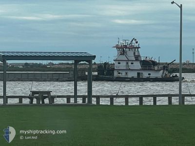
LADY OF PERPETUAL HE
Tug
Current Trip
US^0A6F>0U3H
| Time Travelled | 3 days |
|---|---|
| Remaining Time | --- |
| Distance Travelled | 16.23 nm |
| Remaining Distance | --- |
| AVG Speed | 6.6 Noeuds |
| MAX Speed | 7.6 Noeuds |
| AVG Wind | 13.3 knots |
| MAX Wind | 16.7 knots |
| MIN Temp | 18.3°C / 64.94°F |
| MAX Temp | 23.8°C / 74.84°F |
| Tirant d eau | 3.1 m |
| Position reçue | 1 m depuis |
Current Position
| Longitude | -97.16744° |
|---|---|
| Latitude | 27.85962° |
| Etat | Pushing Ahead - Towing |
| Vitesse | |
| Parcours | 34° |
| Zone | Gulf of Mexico |
| Station | T-AIS |
| Position reçue | 1 m depuis |
Info
Information
The current position of LADY OF PERPETUAL HE is in Gulf of Mexico with coordinates 27.85962° / -97.16744° as reported on 2025-03-25 02:38 by AIS to our vessel tracker app. The vessel's current speed is 0 Noeuds
The vessel LADY OF PERPETUAL HE (MMSI: 367328790) is a Tug It's sailing under the flag of [US] USA.
In this page you can find informations about the vessels current position, last detected port calls, and current voyage information. If the vessels is not in coverage by AIS you will find the latest position.
The current position of LADY OF PERPETUAL HE is detected by our AIS receivers and we are not responsible for the reliability of the data. The last position was recorded while the vessel was in Coverage by the Ais receivers of our vessel tracking app.
The current draught of LADY OF PERPETUAL HE as reported by AIS is 3.1 meters
Weather
| Temperature | 21.4°C / 70.52°F |
|---|---|
| Wind Speed | 10 knots |
| Direction | 128° SE |
| Pressure | 1015.5 hPa |
| Humidity | 87.7 % |
| Cloud Coverage | 3 % |
Featured Company
Last Port Calls
| Port | Arrival | Departure | Time In Port |
|---|---|---|---|
| 2025-03-20 21:03 | 2025-03-21 09:44 | 12 h | |
| 2025-03-13 09:55 | 2025-03-13 10:14 | 19 m | |
| 2025-03-11 02:29 | 2025-03-11 04:09 | 1 h | |
| 2025-03-07 22:24 | |||
| 2025-03-02 13:06 | 2025-03-06 19:38 | 4 d | |
| 2025-02-28 17:36 | 2025-02-28 21:40 | 4 h | |
| 2025-02-27 13:06 | 2025-02-27 15:38 | 2 h | |
| 2025-02-21 04:08 | 2025-02-21 05:35 | 1 h | |
| 2025-02-09 10:42 | |||
| 2025-01-29 21:45 | 2025-02-01 09:34 | 2 d |
Most Visited Ports (Last year)
| Port | Arrivals | |
|---|---|---|
| 24 | ||
| 11 | ||
| 8 | ||
| 8 | ||
| 7 | ||
| 1 |
Last Trips
| Origin | Departure | Destination | Arrival | Distance | |
|---|---|---|---|---|---|
| 2025-03-13 10:14 | 2025-03-20 21:03 | 135.96 nm | |||
| 2025-03-11 04:09 | 2025-03-13 09:55 | 94.16 nm | |||
| 2025-03-06 19:38 | 2025-03-07 22:24 | 69.55 nm | |||
| 2025-02-28 21:40 | 2025-03-02 13:06 | 116.82 nm | |||
| 2025-02-27 15:38 | 2025-02-28 17:36 | 99.55 nm | |||
| 2025-02-21 05:35 | 2025-02-27 13:06 | 198.23 nm | |||
| 2025-02-01 09:34 | 2025-02-09 10:42 | 381.88 nm | |||
| 2025-01-15 23:17 | 2025-01-29 21:45 | 285.74 nm | |||
| 2025-01-01 14:48 | 2025-01-05 08:40 | 310.40 nm | |||
| 2024-12-31 14:18 | 2025-01-01 05:49 | 88.54 nm |
Events
| Heure | Evenement | Détails | Position/ Destination | Info |
|---|---|---|---|---|
| 2025-03-22 01:20 | Arret | 2.58 nm, South West of ARANSAS PASS |
27.85724 / -97.16801
US^0A6F>0U3H
|
Vitesse: 0.1 kn Parcours: 11° |
| 2025-03-21 22:52 | Démarrage | 2.85 nm, West of CORPUS CHRISTI |
27.82364 / -97.43618
US^0A6F>0U3H
|
Vitesse: 6.7 kn Parcours: 113.1° |
| 2025-03-21 14:44 | Dans la zone couverte |
27.82496 / -97.43853
Gulf of Mexico
|
Vitesse: Parcours: 286° |
|
| 2025-03-21 14:44 | PORT DE DEPART |
|
27.82495 / -97.43852
US^0A6F>0U3H
|
Vitesse: Parcours: 286° |
| 2025-03-21 03:04 | Hors de la zone couverte |
27.89832 / -97.13718
Gulf of Mexico
[US] ARANSAS PASS
|
Vitesse: Parcours: 238.6° |
|
| 2025-03-21 02:03 | Arret |
27.89831 / -97.13717
[US] ARANSAS PASS
|
Vitesse: Parcours: 288° |
|
| 2025-03-21 02:03 | Port d'arrivée |
|
27.89831 / -97.13717
[US] ARANSAS PASS
|
Vitesse: 7 kn Parcours: 24° |
| 2025-03-21 01:30 | Démarrage | 2.23 nm, South West of ARANSAS PASS |
27.86247 / -97.16504
US^0A6F>0U3H
|
Vitesse: 6.3 kn Parcours: 30.7° |
| 2025-03-18 20:06 | Arret | 2.37 nm, South West of ARANSAS PASS |
27.86057 / -97.16642
US^0A6F>0U3H
|
Vitesse: 0.2 kn Parcours: 24° |
| 2025-03-18 20:04 | Dans la zone couverte |
27.86021 / -97.16632
Gulf of Mexico
|
Vitesse: 4.1 kn Parcours: 225° |