
MAX SCHULTE
Cargo
Current Trip
| Trip Time | 5 days |
|---|---|
| Trip Distance | 1955.59 nm |
| AVG Speed | 13.8 Noeuds |
| MAX Speed | 18.4 Noeuds |
| Tirant d eau | 8 m |
| AVG Wind | 12.2 knots |
| MAX Wind | 24 knots |
| MIN Temp | 0.6°C / 33.08°F |
| MAX Temp | 27.1°C / 80.78°F |
| Position reçue | 1 m depuis |
Current Position
| Longitude | -79.88527° |
|---|---|
| Latitude | 9.37226° |
| Etat | Under way using engine |
| Vitesse | |
| Parcours | 55° |
| Zone | Caribbean Sea |
| Station | T-AIS |
| Position reçue | 1 m depuis |
Info
Information
The current position of MAX SCHULTE is in Caribbean Sea with coordinates 9.37226° / -79.88527° as reported on 2025-02-08 11:00 by AIS to our vessel tracker app. The vessel's current speed is 0 Noeuds and is currently inside the port of COLON.
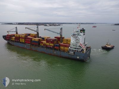
The vessel MAX SCHULTE (IMO: 9676711, MMSI: 565380000) is a Cargo It's sailing under the flag of [SG] Singapore.
In this page you can find informations about the vessels current position, last detected port calls, and current voyage information. If the vessels is not in coverage by AIS you will find the latest position.
The current position of MAX SCHULTE is detected by our AIS receivers and we are not responsible for the reliability of the data. The last position was recorded while the vessel was in Coverage by the Ais receivers of our vessel tracking app.
The current draught of MAX SCHULTE as reported by AIS is 8 meters
Weather
| Temperature | 24.3°C / 75.74°F |
|---|---|
| Wind Speed | 7 knots |
| Direction | 28° NNE |
| Pressure | 1010.5 hPa |
| Humidity | 86.8 % |
| Cloud Coverage | 15 % |
Featured Company
Last Port Calls
| Port | Arrival | Departure | Time In Port |
|---|---|---|---|
| 2025-02-08 10:44 | |||
| 2025-02-02 12:07 | 2025-02-03 00:30 | 12 h | |
| 2025-01-25 16:09 | 2025-01-27 17:04 | 2 d | |
| 2025-01-22 06:19 | 2025-01-23 04:27 | 22 h | |
| 2025-01-16 02:13 | 2025-01-17 04:51 | 1 d | |
| 2025-01-12 23:06 | 2025-01-14 04:31 | 1 d | |
| 2025-01-07 05:51 | 2025-01-08 02:39 | 20 h | |
| 2025-01-02 21:07 | 2025-01-03 10:07 | 13 h | |
| 2024-12-23 23:59 | 2024-12-25 16:19 | 1 d | |
| 2024-12-16 23:10 | 2024-12-18 01:06 | 1 d |
Last Trips
| Origin | Departure | Destination | Arrival | Distance | |
|---|---|---|---|---|---|
| 2025-02-02 19:30 | 2025-02-08 05:44 | 1955.59 nm | |||
| 2025-01-27 12:04 | 2025-02-02 07:07 | 1968.77 nm | |||
| 2025-01-22 23:27 | 2025-01-25 11:09 | 33.30 nm | |||
| 2025-01-16 23:51 | 2025-01-22 01:19 | 298.00 nm | |||
| 2025-01-13 23:31 | 2025-01-15 21:13 | 305.26 nm | |||
| 2025-01-07 21:39 | 2025-01-12 18:06 | 1242.15 nm | |||
| 2025-01-03 05:07 | 2025-01-07 00:51 | 910.27 nm | |||
| 2024-12-25 11:19 | 2025-01-02 16:07 | 2091.15 nm | |||
| 2024-12-17 19:06 | 2024-12-23 18:59 | 1624.37 nm | |||
| 2024-12-12 11:51 | 2024-12-16 17:10 | 1105.81 nm |
Events
| Heure | Evenement | Détails | Position/ Destination | Info |
|---|---|---|---|---|
| 2025-02-08 10:55 | Arret |
9.37214 / -79.88509
[PA] COLON
|
Vitesse: 0.3 kn Parcours: 53° |
|
| 2025-02-08 10:44 | Port d'arrivée |
|
9.36907 / -79.88909
[PA] COLON
|
Vitesse: 2.2 kn Parcours: 75° |
| 2025-02-08 07:32 | Etat Changé | Under way using engine Default |
9.62138 / -79.85504
PAONX
|
Vitesse: 13.9 kn Parcours: 200° |
| 2025-02-08 07:14 | Etat Changé | Default Under way using engine |
9.68440 / -79.82993
PAONX
|
Vitesse: 14.1 kn Parcours: 201.5° |
| 2025-02-08 07:01 | Etat Changé | Under way using engine Default |
9.73202 / -79.81058
PAONX
|
Vitesse: 13.9 kn Parcours: 200° |
| 2025-02-08 06:58 | Etat Changé | Default Under way using engine |
9.74206 / -79.80644
PAONX
|
Vitesse: 14.2 kn Parcours: 207.5° |
| 2025-02-08 06:44 | Detecté en mer | Panamanian part of the Caribbean Sea |
9.79296 / -79.78061
Caribbean Sea
PAONX
|
Vitesse: 14.2 kn Parcours: 205.6° |
| 2025-02-08 06:44 | Etat Changé | Under way using engine Default |
9.79296 / -79.78061
PAONX
|
Vitesse: 14 kn Parcours: 210° |
| 2025-02-08 06:26 | Dans la zone couverte |
9.79296 / -79.78061
Caribbean Sea
PAONX
|
Vitesse: 14.2 kn Parcours: 205.6° |
|
| 2025-02-05 23:06 | Hors de la zone couverte |
22.35529 / -73.37755
North Atlantic Ocean
PAONX
|
Vitesse: 16.1 kn Parcours: 195.9° |