
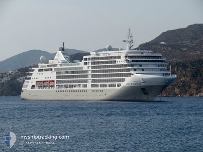
SILVER SPIRIT
Not available
Current Trip
| Time Travelled | 2 days |
|---|---|
| Remaining Time | 6 h, 58 mins |
| Distance Travelled | 1035.30 nm |
| Remaining Distance | 126.44 nm |
| AVG Speed | 16.6 Noeuds |
| MAX Speed | 17.8 Noeuds |
| AVG Wind | 11.3 knots |
| MAX Wind | 21.8 knots |
| MIN Temp | 13.3°C / 55.94°F |
| MAX Temp | 21.3°C / 70.34°F |
| Tirant d eau | 6 m |
| Position reçue | 16 h, 48 m depuis |
Current Position
| Longitude | 18.38441° |
|---|---|
| Latitude | -34.46200° |
| Etat | Under way using engine |
| Vitesse | 15.6 Noeuds |
| Parcours | 148° |
| Zone | South Atlantic Ocean |
| Station | T-AIS |
| Position reçue | 16 h, 48 m depuis |
Info
Information
The current position of SILVER SPIRIT is in South Atlantic Ocean with coordinates -34.46200° / 18.38441° as reported on 2025-02-13 09:33 by AIS to our vessel tracker app. The vessel's current speed is 15.6 Noeuds and is heading at the port of PORT ELIZABETH. The estimated time of arrival as calculated by MyShipTracking vessel tracking app is 2025-02-14 09:19 LT
The vessel SILVER SPIRIT (MMSI: 311022500) is a Not available It's sailing under the flag of [BS] Bahamas.
In this page you can find informations about the vessels current position, last detected port calls, and current voyage information. If the vessels is not in coverage by AIS you will find the latest position.
The current position of SILVER SPIRIT is detected by our AIS receivers and we are not responsible for the reliability of the data. The last position was recorded while the vessel was in Coverage by the Ais receivers of our vessel tracking app.
The current draught of SILVER SPIRIT as reported by AIS is 6 meters
Weather
| Temperature | 19.7°C / 67.46°F |
|---|---|
| Wind Speed | 11 knots |
| Direction | 259° W |
| Pressure | 1015 hPa |
| Humidity | 66.7 % |
| Cloud Coverage | 52 % |
Featured Company
Last Port Calls
| Port | Arrival | Departure | Time In Port |
|---|---|---|---|
| 2025-02-10 05:48 | 2025-02-11 12:00 | 1 d | |
| 2025-02-09 04:35 | 2025-02-09 12:24 | 7 h | |
| 2025-02-07 04:11 | 2025-02-07 18:09 | 13 h | |
| 2025-02-04 05:08 | 2025-02-04 17:18 | 12 h | |
| 2025-02-03 05:12 | 2025-02-03 18:00 | 12 h | |
| 2025-02-01 05:11 | 2025-02-01 21:03 | 15 h | |
| 2025-01-30 10:19 | 2025-01-31 18:15 | 1 d | |
| 2025-01-26 05:40 | 2025-01-27 12:28 | 1 d | |
| 2025-01-25 04:43 | 2025-01-25 12:13 | 7 h | |
| 2025-01-23 04:05 | 2025-01-23 19:32 | 15 h |
Last Trips
| Origin | Departure | Destination | Arrival | Distance | |
|---|---|---|---|---|---|
| 2025-02-09 14:24 | 2025-02-10 07:48 | 260.80 nm | |||
| 2025-02-07 20:09 | 2025-02-09 06:35 | 491.90 nm | |||
| 2025-02-04 19:18 | 2025-02-07 06:11 | 826.53 nm | |||
| 2025-02-03 20:00 | 2025-02-04 07:08 | 96.27 nm | |||
| 2025-02-01 23:03 | 2025-02-03 07:12 | 350.15 nm | |||
| 2025-01-31 20:15 | 2025-02-01 07:11 | 146.56 nm | |||
| 2025-01-27 14:28 | 2025-01-30 12:19 | 1172.90 nm | |||
| 2025-01-25 14:13 | 2025-01-26 07:40 | 260.27 nm | |||
| 2025-01-23 21:32 | 2025-01-25 06:43 | 491.58 nm | |||
| 2025-01-21 19:00 | 2025-01-23 06:05 | 439.01 nm |
Events
| Heure | Evenement | Détails | Position/ Destination | Info |
|---|---|---|---|---|
| 2025-02-13 09:38 | Etat Changé | Default Under way using engine |
-34.48030 / 18.39749
ZAPLZ
|
Vitesse: 15.6 kn Parcours: 148° |
| 2025-02-13 09:33 | Hors de la zone couverte |
-34.46200 / 18.38441
South Atlantic Ocean
|
Vitesse: 15.6 kn Parcours: 148° |
|
| 2025-02-13 08:24 | Tirant d'eau modifié | 6 6.7 |
-34.19011 / 18.21117
ZAPLZ
|
Vitesse: 16.9 kn Parcours: 156° |
| 2025-02-13 08:06 | Tirant d'eau modifié | 6.7 6 |
-34.11044 / 18.17729
ZAPLZ
|
Vitesse: 17.1 kn Parcours: 160.8° |
| 2025-02-13 08:06 | Changement d'ETA | 2025/02/14 10:00 |
-34.11044 / 18.17729
ZAPLZ
|
Vitesse: 17.1 kn Parcours: 160.8° |
| 2025-02-13 08:00 | Tirant d'eau modifié | 6 6.7 |
-34.08414 / 18.16624
ZAPLZ
|
Vitesse: 16.9 kn Parcours: 159.9° |
| 2025-02-13 07:54 | Tirant d'eau modifié | 6.7 6 |
-34.05808 / 18.15528
ZAPLZ
|
Vitesse: 16.3 kn Parcours: 159.4° |
| 2025-02-13 07:54 | Changement d'ETA | 2025/02/14 10:00 |
-34.05808 / 18.15528
ZAPLZ
|
Vitesse: 16.3 kn Parcours: 159.4° |
| 2025-02-13 07:24 | Tirant d'eau modifié | 6 6.7 |
-33.92926 / 18.10078
ZAPLZ
|
Vitesse: 16.4 kn Parcours: 162.4° |
| 2025-02-13 07:18 | Changement de destination | ZAPLZ ZA LUD |
-33.90232 / 18.08933
ZAPLZ
|
Vitesse: 16.7 kn Parcours: 161.1° |