

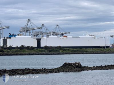
VIKING PAGLIA
Vehicles Carrier

Current Trip
| Time Travelled | 6 days |
|---|---|
| Remaining Time | --- |
| Distance Travelled | 2661.84 nm |
| Remaining Distance | --- |
| AVG Speed | 17 Noeuds |
| MAX Speed | 19.7 Noeuds |
| AVG Wind | 13.4 knots |
| MAX Wind | 37.2 knots |
| MIN Temp | 5.3°C / 41.54°F |
| MAX Temp | 25.8°C / 78.44°F |
| Tirant d eau | 8.2 m |
| Position reçue | 5 d depuis |
Current Position
| Longitude | -126.88048° |
|---|---|
| Latitude | 48.50738° |
| Etat | Under way using engine |
| Vitesse | 15.5 Noeuds |
| Parcours | 268.9° |
| Zone | North Pacific Ocean |
| Station | T-AIS |
| Position reçue | 5 d depuis |
Information
The current position of VIKING PAGLIA is in North Pacific Ocean with coordinates 48.50738° / -126.88048° as reported on 2025-06-04 14:17 by AIS to our vessel tracker app. The vessel's current speed is 15.5 Noeuds and is heading at the port of SHANGHAI. The estimated time of arrival as calculated by MyShipTracking vessel tracking app is 2025-06-16 08:01 LT
The vessel VIKING PAGLIA (IMO: 9427940, MMSI: 538010369) is a Vehicles Carrier that was built in 2010 ( 15 Age ). It's sailing under the flag of [MH] Marshall Is.
In this page you can find informations about the vessels current position, last detected port calls, and current voyage information. If the vessels is not in coverage by AIS you will find the latest position.
The current position of VIKING PAGLIA is detected by our AIS receivers and we are not responsible for the reliability of the data. The last position was recorded while the vessel was in Coverage by the Ais receivers of our vessel tracking app.
The current draught of VIKING PAGLIA as reported by AIS is 8.2 meters
Weather
| Temperature | 6°C / 42.8°F |
|---|---|
| Wind Speed | 10 knots |
| Direction | 275° W |
| Pressure | 1001.9 hPa |
| Humidity | 98 % |
| Cloud Coverage | 100 % |


Featured Company
Last Port Calls
| Port | Arrival | Departure | Time In Port |
|---|---|---|---|
| 2025-06-01 19:08 | 2025-06-03 16:14 | 1 d | |
| 2025-05-31 01:05 | 2025-05-31 23:41 | 22 h | |
| 2025-05-14 23:49 | 2025-05-16 12:22 | 1 d | |
| 2025-05-12 05:52 | 2025-05-13 12:09 | 1 d | |
| 2025-04-27 04:41 | 2025-04-27 22:55 | 18 h | |
| 2025-04-24 06:28 | 2025-04-25 07:15 | 1 d |
Most Visited Ports (Last year)
| Port | Arrivals | |
|---|---|---|
| 5 | ||
| 5 | ||
| 4 | ||
| 3 | ||
| 3 | ||
| 3 |
Last Trips
| Origin | Departure | Destination | Arrival | Distance | |
|---|---|---|---|---|---|
| 2025-05-31 23:41 | 2025-06-01 19:08 | 185.27 nm | |||
| 2025-05-16 12:22 | 2025-05-31 01:05 | 5200.66 nm | |||
| 2025-05-13 12:09 | 2025-05-14 23:49 | 67.85 nm | |||
| 2025-04-27 22:55 | 2025-05-12 05:52 | 5156.68 nm | |||
| 2025-04-25 07:15 | 2025-04-27 04:41 | 188.26 nm | |||
| 2025-03-25 20:22 | 2025-04-24 06:28 | 9365.14 nm |
Events
| Heure | Evenement | Détails | Position/ Destination | Info |
|---|---|---|---|---|
| 2025-06-04 14:22 | Etat Changé | Default Under way using engine |
48.50699 / -126.91299
US TIW > CN SHA
|
Vitesse: 15.5 kn Parcours: 268.9° |
| 2025-06-04 14:17 | Hors de la zone couverte |
48.50738 / -126.88048
North Pacific Ocean
US TIW > CN SHA
|
Vitesse: 15.5 kn Parcours: 268.9° |
|
| 2025-06-04 09:55 | Etat Changé | Under way using engine Default |
48.52376 / -125.10065
US TIW > CN SHA
|
Vitesse: 14.6 kn Parcours: 273° |
| 2025-06-04 09:44 | Etat Changé | Default Under way using engine |
48.52269 / -125.03797
US TIW > CN SHA
|
Vitesse: 14.7 kn Parcours: 270.7° |
| 2025-06-04 09:43 | Etat Changé | Under way using engine Default |
48.52266 / -125.03127
US TIW > CN SHA
|
Vitesse: 14.4 kn Parcours: 271° |
| 2025-06-04 09:33 | Etat Changé | Default Under way using engine |
48.52191 / -124.96514
US TIW > CN SHA
|
Vitesse: 14.7 kn Parcours: 271.9° |
| 2025-06-04 09:32 | Etat Changé | Under way using engine Default |
48.52183 / -124.95902
US TIW > CN SHA
|
Vitesse: 14.9 kn Parcours: 270° |
| 2025-06-04 09:13 | Etat Changé | Default Under way using engine |
48.52045 / -124.84260
US TIW > CN SHA
|
Vitesse: 14.5 kn Parcours: 270.4° |
| 2025-06-04 09:05 | Etat Changé | Under way using engine Default |
48.52016 / -124.79811
US TIW > CN SHA
|
Vitesse: 14.5 kn Parcours: 272° |
| 2025-06-04 08:56 | Detecté en mer | Canadian part of the North Pacific Ocean |
48.51272 / -124.74439
North Pacific Ocean
US TIW > CN SHA
|
Vitesse: 14.7 kn Parcours: 291.9° |