

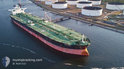
ALMI HYDRA
Crude Oil Tanker

Current Trip
| Time Travelled | 16 days |
|---|---|
| Remaining Time | --- |
| Distance Travelled | 4999.55 nm |
| Remaining Distance | --- |
| AVG Speed | 13.1 Knopen |
| MAX Speed | 15.5 Knopen |
| AVG Wind | 11.6 knots |
| MAX Wind | 20.9 knots |
| MIN Temp | 8.2°C / 46.76°F |
| MAX Temp | 27.9°C / 82.22°F |
| Diepgang | 20.5 M |
| Positie ontvangen | 6 d geleden |
Current Position
| Lengtegraad | -18.25489° |
|---|---|
| Breedtegraat | 10.65191° |
| Status | Under way using engine |
| Snelheid | 13.4 Knopen |
| Koers | 145.8° |
| Gebied | North Atlantic Ocean |
| Station | T-AIS |
| Positie ontvangen | 6 d geleden |
Information
The current position of ALMI HYDRA is in North Atlantic Ocean with coordinates 10.65191° / -18.25489° as reported on 2025-05-29 02:53 by AIS to our vessel tracker app. The vessel's current speed is 13.4 Knopen and is heading at the port of NINGBO. The estimated time of arrival as calculated by MyShipTracking vessel tracking app is 2025-07-03 03:00 LT
The vessel ALMI HYDRA (IMO: 9583720, MMSI: 636019913) is a Crude Oil Tanker that was built in 2013 ( 12 Jaar oud ). It's sailing under the flag of [LR] Liberia.
In this page you can find informations about the vessels current position, last detected port calls, and current voyage information. If the vessels is not in coverage by AIS you will find the latest position.
The current position of ALMI HYDRA is detected by our AIS receivers and we are not responsible for the reliability of the data. The last position was recorded while the vessel was in Coverage by the Ais receivers of our vessel tracking app.
The current draught of ALMI HYDRA as reported by AIS is 20.5 meters
Weather
| Temperature | 22.2°C / 71.96°F |
|---|---|
| Wind Speed | 10 knots |
| Direction | 127° SE |
| Pressure | 1016.3 hPa |
| Humidity | 63.5 % |
| Cloud Coverage | 60 % |


Featured Company
Last Port Calls
| Port | Arrival | Departure | Time In Port |
|---|---|---|---|
| 2025-05-13 11:07 | 2025-05-19 05:43 | 5 d | |
| 2025-04-23 11:03 | 2025-04-25 17:47 | 2 d |
Most Visited Ports (Last year)
| Port | Arrivals | |
|---|---|---|
| 3 | ||
| 2 | ||
| 2 | ||
| 1 | ||
| 1 |
Last Trips
| Origin | Departure | Destination | Arrival | Distance | |
|---|---|---|---|---|---|
| 2025-04-25 17:47 | 2025-05-13 11:07 | 2543.92 nm | |||
| 2025-03-29 18:05 | 2025-04-23 11:03 | 6248.97 nm |
Events
| Tijd | Evenement | Details | Positie / Bestemming | Info |
|---|---|---|---|---|
| 2025-05-29 03:00 | Status Changed | Default Under way using engine |
10.63288 / -18.24157
GB HPT>>CN NGB
|
Snelheid: 13.4 kn Koers: 145.8° |
| 2025-05-29 02:53 | Buitenbereik |
10.65191 / -18.25489
North Atlantic Ocean
|
Snelheid: 13.4 kn Koers: 145.8° |
|
| 2025-05-29 02:50 | Status Changed | Under way using engine Default |
10.66151 / -18.26175
GB HPT>>CN NGB
|
Snelheid: 13.4 kn Koers: 146° |
| 2025-05-29 02:35 | Status Changed | Default Under way using engine |
10.70777 / -18.29472
GB HPT>>CN NGB
|
Snelheid: 13.3 kn Koers: 144.6° |
| 2025-05-29 02:26 | Status Changed | Under way using engine Default |
10.73409 / -18.31358
GB HPT>>CN NGB
|
Snelheid: 13.3 kn Koers: 145° |
| 2025-05-29 02:19 | Status Changed | Default Under way using engine |
10.75780 / -18.33056
GB HPT>>CN NGB
|
Snelheid: 13.4 kn Koers: 145.2° |
| 2025-05-29 01:38 | Status Changed | Under way using engine Default |
10.88380 / -18.41849
GB HPT>>CN NGB
|
Snelheid: 13.4 kn Koers: 145° |
| 2025-05-29 01:04 | Status Changed | Default Under way using engine |
10.98459 / -18.49121
GB HPT>>CN NGB
|
Snelheid: 13.2 kn Koers: 143.3° |
| 2025-05-29 00:29 | Wijzig zee gebeid | Guinea Bissau part of the North Atlantic Ocean Senegalese part of the North Atlantic Ocean |
11.09275 / -18.56411
North Atlantic Ocean
|
Snelheid: 13.1 kn Koers: 146.5° |
| 2025-05-29 00:29 | Status Changed | Under way using engine Default |
11.09275 / -18.56411
GB HPT>>CN NGB
|
Snelheid: 12.9 kn Koers: 145° |