
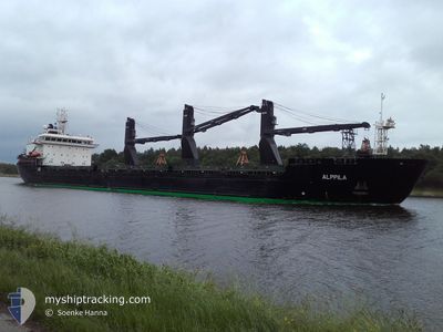
ALPPILA
Bulk Carrier
Current Trip
| Time Travelled | 1 h, 45 mins |
|---|---|
| Remaining Time | 5 h, 31 mins |
| Distance Travelled | 13.99 nm |
| Remaining Distance | 63.19 nm |
| AVG Speed | 9.6 Knopen |
| MAX Speed | 12.9 Knopen |
| AVG Wind | 6.3 knots |
| MAX Wind | 9 knots |
| MIN Temp | -13°C / 8.6°F |
| MAX Temp | -9.6°C / 14.72°F |
| Diepgang | 9.6 M |
| Positie ontvangen | 57 m geleden |
Current Position
| Lengtegraad | 22.43815° |
|---|---|
| Breedtegraat | 65.48287° |
| Status | Under way using engine |
| Snelheid | 6.4 Knopen |
| Koers | 130° |
| Gebied | Gulf of Bothnia |
| Station | T-AIS |
| Positie ontvangen | 57 m geleden |
Info
Information
The current position of ALPPILA is in Gulf of Bothnia with coordinates 65.48287° / 22.43815° as reported on 2025-02-13 09:55 by AIS to our vessel tracker app. The vessel's current speed is 6.4 Knopen and is heading at the port of VIRPIPERA. The estimated time of arrival as calculated by MyShipTracking vessel tracking app is 2025-02-13 18:24 LT
The vessel ALPPILA (IMO: 9381706, MMSI: 230613000) is a Bulk Carrier that was built in 2011 ( 14 Jaar oud ). It's sailing under the flag of [FI] Finland.
In this page you can find informations about the vessels current position, last detected port calls, and current voyage information. If the vessels is not in coverage by AIS you will find the latest position.
The current position of ALPPILA is detected by our AIS receivers and we are not responsible for the reliability of the data. The last position was recorded while the vessel was in Coverage by the Ais receivers of our vessel tracking app.
The current draught of ALPPILA as reported by AIS is 9.6 meters
Weather
| Temperature | -9.9°C / 14.18°F |
|---|---|
| Wind Speed | 9 knots |
| Direction | 343° NNW |
| Pressure | 1031.3 hPa |
| Humidity | 94.7 % |
| Cloud Coverage | 34 % |
Featured Company
Last Port Calls
| Port | Arrival | Departure | Time In Port |
|---|---|---|---|
| 2025-02-12 15:51 | 2025-02-13 10:08 | 18 h | |
| 2025-02-09 23:17 | 2025-02-12 07:34 | 2 d | |
| 2025-02-08 12:01 | 2025-02-09 15:04 | 1 d | |
| 2025-02-01 05:39 | 2025-02-02 11:24 | 1 d | |
| 2025-01-29 10:00 | 2025-01-30 01:03 | 15 h | |
| 2025-01-26 09:43 | 2025-01-29 02:36 | 2 d | |
| 2025-01-13 06:22 | 2025-01-14 09:40 | 1 d | |
| 2024-12-27 04:35 | 2024-12-31 13:45 | 4 d | |
| 2024-12-08 23:41 | |||
| 2024-12-06 06:37 | 2024-12-07 14:45 | 1 d |
Last Trips
| Origin | Departure | Destination | Arrival | Distance | |
|---|---|---|---|---|---|
| 2025-02-12 07:34 | 2025-02-12 15:51 | 80.74 nm | |||
| 2025-02-09 15:04 | 2025-02-09 23:17 | 77.03 nm | |||
| 2025-02-02 11:24 | 2025-02-08 12:01 | 532.57 nm | |||
| 2025-01-30 01:03 | 2025-02-01 05:39 | 514.97 nm | |||
| 2025-01-29 02:36 | 2025-01-29 10:00 | 72.61 nm | |||
| 2025-01-14 09:40 | 2025-01-26 09:43 | 1804.63 nm | |||
| 2024-12-31 13:45 | 2025-01-13 06:22 | 1403.13 nm | |||
| 2024-12-07 14:45 | 2024-12-08 23:41 | 350.85 nm | |||
| 2024-12-04 07:46 | 2024-12-06 06:37 | 515.19 nm | |||
| 2024-12-01 11:24 | 2024-12-03 12:38 | 516.03 nm |
Events
| Tijd | Evenement | Details | Positie / Bestemming | Info |
|---|---|---|---|---|
| 2025-02-13 10:01 | Status Changed | Default Under way using engine |
65.47312 / 22.46458
SE LLA>FI RAA
|
Snelheid: 6.4 kn Koers: 130° |
| 2025-02-13 09:53 | Start beweging | 8.56 nm, South East of LULEA |
65.48475 / 22.43264
SE LLA>FI RAA
|
Snelheid: 4.2 kn Koers: 128° |
| 2025-02-13 09:47 | Stop beweging | 8.43 nm, South East of LULEA |
65.48608 / 22.42848
SE LLA>FI RAA
|
Snelheid: 0.3 kn Koers: 126° |
| 2025-02-13 09:08 | Vertrekhaven |
|
65.54220 / 22.29363
SE LLA>FI RAA
|
Snelheid: 8.5 kn Koers: 114° |
| 2025-02-13 08:52 | Start beweging |
65.55189 / 22.20618
[SE] LULEA
|
Snelheid: 4.8 kn Koers: 99° |
|
| 2025-02-13 08:37 | Stop beweging |
65.55194 / 22.20156
[SE] LULEA
|
Snelheid: 0.3 kn Koers: 293° |
|
| 2025-02-13 08:11 | Start beweging |
65.54466 / 22.28355
[SE] LULEA
|
Snelheid: 3.1 kn Koers: 274° |
|
| 2025-02-13 08:05 | ETA Changed | 2025/02/13 16:00 2025/02/09 21:00 |
65.54449 / 22.28786
[SE] LULEA
|
Snelheid: Koers: 282° |
| 2025-02-13 08:05 | Status Changed | Under way using engine Moored |
65.54449 / 22.28785
[SE] LULEA
|
Snelheid: Koers: 282° |
| 2025-02-13 08:03 | Status Changed | Moored Default |
65.54449 / 22.28786
[SE] LULEA
|
Snelheid: Koers: 282° |